Need help with an emergency event happening right now?
How we can help with recovery
Access to Crown land, waterways and lakes
We are the central agency responsible for Crown property acquisition, management and disposal. This means that we can make Crown land available for use after an emergency and can help you get authorisation to fly drones on Crown land (including Department of Conservation land).
Our Land and Property teams in Wellington and Christchurch have technical experience under the Public Works Act. They provide centralised property acquisition, management and disposal services for other Crown agencies.
View the land we manage on the LINZ Data Service
Demolition and land remediation
Toitū Te Whenua has an established demolition team with significant operational experience gained responding to the Christchurch earthquakes. The team has proven systems and specialist contractors available to provide advice on Crown property. This includes:
- safe, effective and cost-efficient demolition of damaged or at-risk buildings
- land remediation services in high-risk, post-event environments
- support in securing damaged or at-risk buildings.
For more information, contact crownproperty@linz.govt.nz

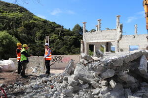
We are demolition experts with significant experience in high-risk, post-event environments, such as the Port Hills Red Zone in Christchurch. Image by Matt Bradley.
Monitoring earth movements
We are New Zealand’s experts in precise coordinate and positioning information. Horizontal and vertical coordinate and positioning information can tell you the extent and impact of earth movement caused by an event. Our positioning teams were deployed directly after the Kaikōura earthquake to provide updated geodetic control to help support recovery.
Read more about modernising height data
For more information, contact emergency@linz.govt.nz
Property rights and surveying
Events such as earthquakes can cause the land to move and change property boundaries. We can help determine the impact of earth movement on property boundaries and give guidance for surveyors to help rebuild. We can also help identify and coordinate surveyors to monitor buildings and structures during recovery.
For more information, contact surveyorgeneral@linz.govt.nz
Property valuation
A disaster could affect the value of property. The rating valuation process in Canterbury was significantly affected by the 2010 and 2011 earthquakes. More recently in 2023, the Auckland Floods and Cyclone Gabrielle had a significant impact in Auckland, Hawke’s Bay and Tairawhiti.
We do not carry out valuations, but the Office of the Valuer-General at Toitū Te Whenua sets standards for rating valuations, and audits local authorities to ensure values are consistent across New Zealand.
For more information, email valuergeneral@linz.govt.nz