The relationship between New Zealand Vertical Datum 2016 (NZVD2016) and the 13 local level datums (LVDs) has been published as a set of vertical datum relationship grids.
New Zealand Vertical Datum 2016
Vertical datum relationship grids
These relationship grids were calculated using geodetic control marks with both an ellipsoidal and a normal-orthometric height. The difference between to the values was modelled on a grid with a 2 arc minute spacing (approximately 3.6km). These grids only cover the areas where LINZ holds marks in a specific LVD. For example, the Auckland 1946 to NZVD2016 grid includes Auckland, Hamilton and Tauranga, but does not extend as far south as Rotorua.
Trig stations and geodetic marks
New Zealand Geodetic Datum 2000 ellipsoidal heights
Auckland 1946 to NZVD2016 conversion grid
The grids were computed using a ‘best fit method’, meaning that the grid is not forced to pass through the values at the observation points. Parameters allowed a point error of 1mm and a distortion error of 0.5ppm, and tend toward the mean datum relationship value (listed in the table below) in areas where there are no observation points.
Note that when using relationship grids in software such as GIS, the raster images provided in the LINZ Data Service are not a transformation surface. A surface must be created using a bi-linear interpolation method to determine the correct offset values.
Example
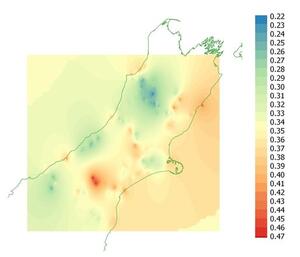
Vertical Datum Relationship Grid Lyttelton 1937 to NZVD2016

This diagram demonstrates how the difference between NZVD2016 and Lyttelton 1937 varies by 0.22 – 0.47cm across the area defined by Lyttelton datum.
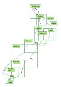
The location and extent of each LVD is shown in the image below.

Map of New Zealand showing LVD location and extents
| Region | Local vertical datum | number of control marks | Mean (m) | Standard Deviation | Min (m) | Max (m) | Range (m) | Reference Mark | Datum Relationship at Reference | Relationship Grid | Grid Version |
|---|---|---|---|---|---|---|---|---|---|---|---|
| One Tree Point | One Tree Point 1964 | 137 | 0.077 | 0.042 | -0.03 | 0.155 | 0.185 | RNZN BM (DJM9) | 0.080 | OTP64-NZVD16 | 2016.1 |
| Auckland | Auckland 1946 | 260 | 0.292 | 0.029 | 0.226 | 0.367 | 0.142 | 98-21 SO 69501 (DD1N) | 0.367 | AUK46-NZVD16 | 2016.1 |
| Moturiki | Moturiki 1953 | 519 | 0.309 | 0.071 | 0.140 | 0.540 | 0.401 | BC 84 (B309) | 0.199 | MOT53-NZVD16 | 2016.1 |
| Gisborne | Gisborne 1926 | 274 | 0.343 | 0.025 | 0.253 | 0.397 | 0.143 | GB 01 (ACVP) | 0.361 | GSB26-NZVD16 | 2016.1 |
| Napier | Napier 1962 | 207 | 0.203 | 0.034 | 0.124 | 0.299 | 0.175 | H 40 (B3XM) | 0.193 | NPR62-NZVD16 | 2016.1 |
| Taranaki | Taranaki 1970 | 125 | 0.286 | 0.026 | 0.216 | 0.356 | 0.140 | New Plymouth Fundamental (AGMH) | 0.297 | TNK70-NZVD16 | 2016.1 |
| Wellington | Wellington 1953 | 137 | 0.408 | 0.054 | 0.296 | 0.517 | 0.221 | K 80/1 (ABPB) | 0.388 | WGN53-NZVD16 | 2016.1 |
| Nelson | Nelson 1955 | 256 | 0.329 | 0.039 | 0.215 | 0.440 | 0.225 | N 1 (AC4T) | 0.330 | NSN55-NZVD16 | 2016.1 |
| Lyttelton | Lyttelton 1937 | 923 | 0.340 | 0.041 | 0.200 | 0.489 | 0.289 | UD 40 (B40V) | 0.389 | LTN37-NZVD16 | 2016.1 |
| Dunedin | Dunedin 1958 | 197 | 0.326 | 0.043 | 0.174 | 0.458 | 0.284 | WW 83 (AFEQ) | 0.377 | DUN58-NZVD16 | 2016.1 |
| Dunedin-Bluff | Dunedin-Bluff 1960 | 205 | 0.254 | 0.039 | 0.154 | 0.364 | 0.210 | Z 41 (B3R8) | 0.329 | DBL60-NZVD16 | 2016.1 |
| Bluff | Bluff 1955 | 71 | 0.273 | 0.034 | 0.213 | 0.352 | 0.138 | Bluff Fundamental (ABCC) | 0.316 | BLF55-NZVD16 | 2016.1 |
| Stewart Island | Stewart Island 1977 | 4 | 0.299 | 0.025 | 0.276 | 0.338 | 0.062 | N (Paterson SD) (A017) | 0.299 | STI77-NZVD16 | 2016.1 |