
From Landonline release 3.24
Issue - Landonline business rule C640 incorrectly warns that a connection has not been made to a cadastral survey network mark (CSNM)
Description
Landonline business rule C640 tests whether the survey connects to a CSNM as required by CSR 2021 r 17(1). It also tests that the connection has been made by adoption or measurement r 17(2).
To satisfy rule 17(1)(a), only one of the qualifying boundary marks has to be connected by one or more vectors to a CSNM within the 1000m limit.
Where there is a combination of captured CSNMs both inside and outside of the 1000m limit, sometimes Landonline will produce a pre-validation warning indicating that one or more CSNMs have not been connected to, when a valid connection has been made.
Action
Where business rule C640 has failed and you have correctly recorded a measured or adopted connection by one or more vectors to a CSNM as required by CSR 2021 r 17, you should make a note in the survey report to address the pre-validation warning.
We anticipate this will be fixed in Landonline release 3.27 scheduled for late 2022.
Issue - Survey report content cleared when running pre-validation to convert RCS 2010 CSD to CSR 2021
Description
All datasets captured prior to 25 February 2022 and not lodged need to have pre-validation run to convert the dataset into CSR 2021, this will change the survey report from RCS 2010 to CSR 2021. This action will clear all content in the survey report that was previously entered.
Action
Prior to running pre-validation, export the RCS 2010 report or copy the content into a document to retain the information previously entered if it is required to be used in the new report.
A solution to retain the survey report (as occurred prior to 25 February 2022) is under investigation.
Issue (revised 21/12/2021) - Landonline business rule C623 is not running as expected at pre-validation
Description
Landonline business rule C623 tests that at least 2 points on each non-primary parcel are connected to 2 underlying primary parcel points so they can be shown on the survey diagram (CSR 2021 r 89(g)(i)).
Because the C623 business rule is not running as expected the interim solution has been to turn it off in Landonline. A permanent solution is under investigation.
Action
The consequence of this rule being turned off is that you will need to manually check compliance. Confirm the survey diagram depicts connections to every non-primary parcel from a minimum of 2 underlying primary parcel points. For a non-primary only dataset, user added balance distances on the title diagram are acceptable as long as the vectors are also captured.

Issue - CSNM/VCM can be captured as ‘New’ marks even though they are not allowed to be under the CSR-2021.
Description
If a user creates a CSMN/VCM mark as ‘New’ there is no symbology for this and so it takes on the appearance of an Old CSNM/VCM (solid triangle). There are no rules run at pre-validation to check this.

Action
Manually check Capture tables to ensure CSNM/VCM marks are only captured with Mark State of ‘Old’ or ‘Adopted’ and have them edited if Mark State=New”

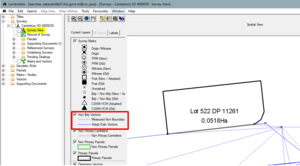
Issue - In Searches, when a new reinstatement survey is added to the ‘Tree’ and the ‘Survey View’ opened, the reinstated vectors do not display.
Description
Two new survey purposes have been introduced under the CSR-2021. ‘Simple Boundary Reinstatement’ and ‘Complex Boundary Reinstatement’. Once either of these plans are added to the ‘Tree’ in Searches, users can open the Survey View to see the captureddata. However, the new ‘Reinstatement Vector’ is not displaying in Current Layers or in the spatial display.
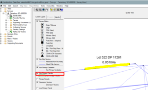
The Reinstatement Vector Layer (taken from Capture Spatial window) is the new vector added to the ‘Captured Non Bdy Vectors’ layer:

Action
You can still use the Survey View and use the labels icons to see the reinstated vector details:
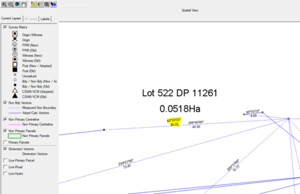
- Open Survey View
- The ‘Current Layers’ tab does not show the new ‘reinstatement vector’ line
- Turn off Primary Parcels layer
- The new Reinstatement Vector does not display spatially
- Select the All Labels icon
– all labels turn on

- Select Individual Labels icon
– only labels for those vectors you select will turn on as shown below:


To view the Reinstatement Vector:
- From Searches Tree, open the ‘Record of Survey’
- Go to the survey sheet images
- The vector that is reinstated displays as a thick line

Issue - When adding information into an already populated automated Schedule/Memorandum, the line entered is not being placed under the already populated schedule. It appears at the bottom of the Preview page.
Description
If the automated Schedule/Memorandum is already populated with schedules, and an additional entry to an existing schedule is required, initially this entry is placed at the bottom of the page rather than in the table it is supposed to be in.
The table below, shows an additional entry to the table ‘Schedule of Easements’ (which already existed) and is placed at the bottom of the page rather than inserting it into the existing ‘Schedule of Easements’ at the top of the page:

Action
To correct the position, click on the ‘Save’ button. That entry is moved into the existing table as expected:

From Landonline release 3.20
Issue - Since Landonline Release 3.20, some surveys are getting the following fatal at Prevalidation, even though the Automated Schedule/Memorandum is completed and matches capture:
"Y027 - Fatal - Some parcels have been removed. Ensure the automated Schedule/Memorandum is updated and reattached"
Description
This Y027 rule is indicating that captured parcels have been removed from spatial capture or the parcel list (or both). These parcels may have been in the original Schedule/Memorandum (possibly attached as a Supporting Document), but do not display in the current Schedule/Memorandum any more. These edits, to capture, may have occurred prior to the 3.20 release.
Looking at the Schedule/Memorandum tab, it may not be obvious as to what is wrong, in fact it may look correct and complete. The problem is that the schedule/memorandum still thinks there is a link to those parcels (now removed) that would have been originally listed in any one of the tables used.
Action
If possible, obtain a copy of the original Schedule/Memorandum and identify those deleted parcels and the tables they were in – see example below:
ORIGINAL SCHEDULE before changes made in Capture:

CURRENT SCHEDULE after changes made in Capture – looks correct but the system is still holding the old values in a table back end, therefore the changes need to be updated (the lines highlighted yellow have been changed and don’t match the previous schedule)

If it is not possible to recall or there is no copy of the original Schedule/Memorandum they were listed in, then edit ALL lines in the Schedule/Memorandum tab using the steps outline below:
Steps:
- Select the affected line (where the removed parcels were once populated.)
- Selected the ‘Edit’ button in the ‘Line’ group box
- Selected the ‘Clear’ button directly below the ‘Shown’ box
- Using the ‘Preview’ window, re-enter the ‘Shown’ and ‘Dominant Tenement’ fields (any fields that have new values now)
- Selected ‘Update Line’.
Repeat these steps for all tables where the deleted parcels were originally created in or in some cases edit and update all lines entered on this tab.
Once the lines have been updated ensure the data is saved and the document re-attached.
Re-run Prevalidation
From Landonline release 3.19
Issue - Plan Generation|Layout Sheets – missing mark labels, bearings and or distances
Description
After diagrams have been laid out on the Layout sheets, some users are finding that not all mark labels, bearings and/or distances are displaying, despite these layers being turned on in Maintain Diagram Layers screen and Maintain Individual Diagrams screen shown in the following screen shots:


Below is an example of missing mark labels (highlighted yellow) yet all the other mark labels are displaying:

Action
If you find any diagrams, that you have laid out, are missing either some mark labels, bearings and/or distances, then the only way to get those labels back is to do the following:
- Close Layout Sheets
- Open Define Diagrams
- Re-define a NEW diagram over the one(s) that is/are corrupt
- Delete the original diagram
- Close Define Diagrams (this will also save your new diagrams)
- Open Layout Sheets – layout the new diagram and check that all labels are now displaying
Note:
Resizing your diagrams in Define Diagrams will not work.
There are cases whereby no labels are displaying at all over the entire diagram or sheet. This is different to the above issue, so please check that you have added the appropriate layers in Maintain Diagram Layers before doing anything.
From Landonline release 3.16
Issue - Display All Creating Documents References in Automated Schedule of Existing Easements
Description
In the new Schedule/Memorandum tab, when creating a Schedule of Existing Easements the ‘Creating Document Reference’ field will draw down all current interests against the head title(s) (as long as these are entered in the Survey Header | Comprised in Reference fields)

Within the Schedule of Existing Easements table under ‘Creating Document Reference’ if there are more than 6 documents it will appear they are not all listed after you select the drop down option in this field

However they are all listed. See the Action points below to see how to view the entire list.
Action
In order to see all the current interests listed in the ‘Creating Document Reference’ drop down list:
- Select the drop down arrow for the field to open the list
- If the document you want is displaying then click on it
- If the document you want is not displaying simply use the mouse wheel to scoll up or down to select the required document (do not select anything until you find the document you require)
Issue - Road Names in Plan Generation – Layout Sheets
Description
There is an on-going issue with road names in Plan Generation | Layout Sheets.
Where new surveys create new road polygons, the new roads are normally captured as one new polygon and given an appellation in that survey.
In the example below this plan created two polygons for road (Lot 901 and Lot 902). You can see there are several road names inside Lot 901 and Lot 902.

Diagram 1
In the spatial window below, if we concentrate on Meadows, Charlbury and Lydiard Drives you can see that there are 3 road names in the one polygon. The polygon is closed off by the areas circled blue but not where the areas are circled red and highlighted yellow
In the DCDB days (Digital Cadastral Database) under the Department of Survey & Land Information (DOSLI), we spent time and closed off road polygons to create smaller polygons for roads to satisfy councils and other end users of our data. This is not the case for new surveys that create new road formations:

Diagram 2

Diagram 3
In this example, as the adjoining road names (Charlbury Drive and Lydiard Drive) are contained within one polygon (to define Lot 902 on the abutting plan) one of these road names will be incorrect.
In this instance the road name circled red (Charlbury Drive) is incorrect – it should be Lydiard Drive:

Diagram 4
Action
There may be other situations where by you may see an incorrect road name appear in Layout Sheets. Please ensure that you check your layout sheets before generating the images and undertake the following steps to correct those road names.
Where an incorrect road name is displayed in the Layout Sheets do one of the following options to:
Option 1
- Select the road name
- Move the road name to the correct location if its displayed incorrectly
- Add the correct road name in User Added Text in the correct location
Option 2
- Hide the road name
- Add the correct road name in User Added Text in the correct location
Issue - Find Work/Request via ‘Survey|TA Certificate’ functionality is returning an error message and throwing users out of Landonline
Description
When users find work using the following action:

The CSL_S07 TA Certification screen opens up.
If users select ‘Search’ then theCLW_S02c - Find Work / Request screen opens up and users can change the Search Criteria from TA Certification Work to Request or Request Manual Copy

However if the user selects either Request or Request Manual Copy an error message returns and user is thrown out of Landonline

For now, if you need to Find Work or a Request please use the Find Work/Request icon in Workspace on the left hand side of your Workspace screen:

Action
For now, if you have more than one TA name into the TA Certification tab then attach a manual TA Certificate to the one that won’t let you add the online TA Certificate.
From Landonline release 3.7
Issue - Landonline release 3.7 was implemented over the weekend of 17-18 March. The Plan Generation Distortion enhancement has caused the following to occur:
- Errors encountered opening Plan Generation Layout Sheets
- Geometry errors encountered opening Plan Generation, Define Diagrams or Layout Sheets
- Where no errors occur opening Layout Sheets but data laid out is now not what it previously looked like
Action
LINZ appreciates that this is causing major problems for some eSurvey users and are giving high priority to resolving these issues. In the meantime:
Where 1 or 2 occurs, please log a call to 0800 665 463 with the CSD number and error message – an Application Specialist will contact the surveyor/technician and work with them to get the plan to open up.
Where 3 occurs, review all layout sheets and where necessary amend the diagrams or edit the layout sheets.
As a result of the new Plan Generation distortion enhancement, there is a greater emphasis on ensuring that all Y rules are satisfied before opening Plan Generation. More importantly, it is essential to check the entire Prevalidation Report, in particular, the two adjustment reports at the bottom of the prevalidation report. If gross errors are reported in either of these adjustments, the risk of things going wrong in Plan Generation is high, so surveyors should ensure that these data capture errors are resolved before attempting to go into Plan Generation.
If you are unsure how to proceed please contact 0800 ONLINE (0800 665 463).
From previous releases
Issue - Error 47 messages
Description
Action
- Open Define Diagrams
- Create a dummy diagram
- Save and close Define Diagrams
- Open Layout Sheets
Note:
We are very keen to hear from anyone who is aware of a specific set of steps which cause the error 47 message next time they re-enter Layout Sheets. Once we can reliably reproduce the fault the fix is usually straightforward
Issue - LOL_Workspace.exe error in Layout Sheets
Description
An unexpected error will occur if user added text is typed beyond the page border using the ‘add text’ icon

"LOL_Workspace.exe has encountered a problem and needs to close. We are sorry for the inconvenience."
Action
When adding text using the Add Text button, do not let any text entered extend over the page border. Alternatively use the Add Text functionality in the side panel.
Issue - Topology is incorrect when XML files are imported into Landonline
Description
Some XML files are being imported into Landonline without correct topology being formed.
The coordGeom name is not present in the XML file. This is what links the parcel boundary to the vectors. Without this link, the parcel boundary will be made up of only captured boundary links. The application (Landonline) is working as it should be.
Action
3rd Party Software Issue - After an XML file is imported into Landonline, surveyors should check that the parcel topology is correct. Open up the Vector capture screen and look at the Layer column. If all vectors listed only show “0-NBdy” then topology was incorrectly formed in the 3rd party application.
Option 1:
In 3rd party software, Surveyors need to ensure that when creating parcels in their 3rd party software, that they link those parcels to the correct spatially defined parcel.
Option 2:
- Open the spatial window
- Open the Parcel list and unlink all the parcels from the parcel list screen In the spatial window select “Captured Parcel Bdy Lines” layer then select by polygon an area that encompasses all the parcels in the survey
- Once this layer is highlighted yellow, right click on mouse and select “delete”
- Refresh the spatial window if need be, and the result will show all parcels created are only captured in the “0-NBdy” layer
- Select each line individually and edit these Non-Boundary lines to the correct layer for which the parcel is intended e.g. “1-Prim”
- Once all parcel boundaries have been amended, re-link all the created parcels in your parcel list.
TPR
7310