
Maps of Te Waipounamu and Te Ika-a-Māui
The second edition 2023
The second edition maps improved on the first edition with corrections, original names restored as cultural redress through Treaty of Waitangi settlements, and names resulting from direct consultation with iwi and hapū. For Te Waipounamu, names were comprehensively reassessed after Te Rūnanga o Ngāi Tahu’s decades of additional research on its cultural heritage, published in its online cultural heritage atlas Kā Huru Manu.
For the most part the correct standardised orthography for place names is used, as confirmed with a licensed translator, Te Haumihiata Mason. However, for some names this was not possible where the kōrero of the name was not known. Treaty settlement place names are shown as legislated. Kōrero in the index was gathered from tangata whenua, authoritative resources, or carried down from the first edition.
The maps are digital products built from layers of geographic information. The landscape is mostly derived from Toitū Te Whenua Land Information New Zealand’s topographic maps.
Starting with modern accurate data, the clock was wound back on some of the more notable changes in the landscape over the past two centuries. These include land reclamations, river diversions, the construction of numerous hydro-electrical dams, or natural events such as the uplift of Te Whanganui-a-Orotū in the 1931 Napier earthquake. Some of the place names are for features and places that no longer exist.
Roger Smith at Geographx Ltd showed the vegetation coverage based on work for The Museum of New Zealand Te Papa Tongarewa on pre-1840 maps, and this was supplemented by other sources. The changes are approximate at 1:1 million scale, and are not complete but are representative.
Artwork by Ariki Creative for the second editions
In 1995, renowned artist Cliff Whiting (1936-2017) illustrated beautifully designed taniwha on The Land and its People c.1840 maps. Fast-forward to the present day and on the 2023 editions of the maps Tangata whenua place names, Ariki Creative has continued this legacy of artistic storytelling by embarking on a creative approach that bridges the past and the present, honouring the environment through toi Māori (Māori art) in a remarkable new way.
“The design process started by our team researching and developing a look and feel that felt fresh and original, including developing different looks for the title font, graphics and icons,” says Hori Te Ariki Mataki of Ariki Creative.
Drawing inspiration from Whiting's original work, line style and form, Ariki Creative applied unique elements of toi Māori and design on the new Te Ika-a-Māui and Te Waipounamu maps. The team was led by Hori Te Ariki Mataki, with Te Aotahi Rice-Edwards working on the toi Māori elements, Hanuera Rawson on the illustration of the whenua (landscape) on the backs and Tuha Tuimaka and Mikael Tuhaka on the typography and index page, also on the backs.
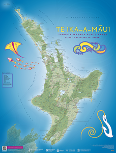
On the Te Ika-a-Māui map, a direct reference to Cliff Whiting’s work resonates through the representation of taniwha, a connection to the children of Tangaroa evoking the ancient lore of the sea. The fishhook of Māui, celebrates the story of Te Ika-a-Māui. A trail of ika (fish) intertwines with a whai or stingray, mirroring the 1995 maps' clustered fish formation, reminiscent of the interconnectedness of place, whakapapa and mātauranga (knowledge). The backdrop is adorned with the kupenga, a net pattern symbolising the art of traditional fishing, and the rauru spiral—a reference to the separation of Ranginui (sky father) and Papatūānuku (earth mother).
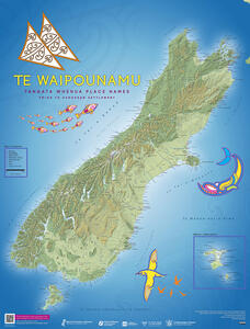
Across the Te Waipounamu map, design and art depict the elements of waka and navigation. The sails of waka hourua (double-hulled canoe) capture the spirit of exploration that has defined generations of tangata whenua. The tohorā (whale), symbolises the connection to the majestic whales. The toroa, the albatross, stands as a symbol of strength and perseverance, a reflection of the enduring mana of the people. Puhoro patterns grace the background, reminiscent of the swirling waters that carry waka taua (war canoe), paying homage to the artistry that adorns these vessels.
“With a profound respect for tangata whenua and their history, whakapapa and mātauranga, our team has worked to design maps that will serve as living tributes to the stories, legends, and land that we all call home,” says Horo Te Ariki Mataki.
The first edition 1995
Read the history behind the maps and download copies
Purchasing the maps
Map retailers and other outlets may hold these maps to sell.
Corrections
The Board acknowledges that there may be errors on the new editions of the maps. If you notice something that needs fixing, please let us know.
Here are some corrections we’ve already made.
Te Ika-a-Māui
| Map name | Action | Where |
|---|---|---|
| Ngaruroro Moko-tū-ā-raro ki Rangatira | ‘Ngaruroro Moko-tū-a-raro ki Rangitira’ corrected to Ngaruroro Moko-tū-ā-raro ki Rangatira | Latest print edition and digital map (front of map) |
| Mataruahou | ‘Mataruahau’ corrected to ‘Mataruahou’ | Latest print edition and digital map (front of map) |
| Aohanga | ‘Aohanga’ corrected to ‘Aohanga River’ | Digital map (index) and web index, in ‘Current name or description’ column |
| Te Whakatūrākau | ‘Te Whakatūrākau’ corrected to ‘Te Whakatūrākau Stream’ | Digital map (index) and web index, in ‘Current name or description’ column |
| Te Roto kite ā Ihenga i ariki ai Kahu | ‘Kahumatamoemoe’ corrected to ‘Kahumatamomoe’ | Digital map (index) and web index, in ‘Kōrero’ column |
| Te Rotorua nui ā Kahumatamomoe | ‘Kahumatamoemoe’ corrected to ‘Kahumatamomoe’ | Digital map (index) and web index, in ‘Kōrero’ column |
| Waihī | ‘Kahumatamoemoe’ corrected to ‘Kahumatamomoe’ | Digital map (index) and web index, in ‘Kōrero’ column |
| Tāmaki-nui-a-Ruamatua | Removed | Digital map (front and back), and web index |
Te Waipounamu
| Map name | Action | Where |
|---|---|---|
| Taumakī | ‘Taumaki’ corrected to ‘Taumakī’ | Digital map (index) and web index, in ‘Name’ column |
| Kohanga-ta-ra | ‘Kohanag-ta-ra’ corrected to ‘Kohanga-ta-ra’ | Digital map (index) and web index, in ‘Name’ column |
| Hautai | ‘seeing ship a long way off’ corrected to ‘seeing a ship a long way off’ | Digital map (index) and web index, in ‘Kōrero’ column |
| Te Tai-o-Mahaanui | ‘cosast’ corrected to ‘coast’ | Digital map (index) and web index in ‘Current name or description’ column |
The kōrero in the indexes on the backs of the printed maps are brief due to limited space. Sometimes the story is more detailed in the New Zealand Gazetteer, but if there is more to the history, origin or meaning, we’d love to hear from you.
Contact us
For any enquiries, comments and feedback please contact
The Secretary/Hēkeretari
Ngā Pou Taunaha o Aotearoa New Zealand Geographic Board
C/- Toitū Te Whenua Land Information New Zealand
PO Box 5501
Wellington 6145
New Zealand
NZGBenquiries@toitutewhenua.govt.nz
Māori place names
“In pre-literate Māori culture there was a huge dependence on memory and the careful transmission of history from generation to generation. The names in the landscape were like survey pegs of memory, marking the events that happened in a particular place, recording some aspect or feature of the traditions and history of a tribe. If the name was remembered it could release whole parcels of history to a tribal narrator and those listening. The daily use of such place names meant that the history was always present, always available. In this sense the living and travelling reinforced the histories of the people.
Some of these groups of names, as well as individual names, were of such significance that when a tribe migrated elsewhere it ‘replanted’ its history in its new home by naming its new landscape with the names of the place of origin. Because of the role of place names as a device for recording and remembering tribal history the historical events themselves sometimes became relocated in the new setting. This is one of the reasons why some Māori and Polynesian histories appear so similar and repetitious. They may be the same story repeated in fresh settings. This does not make the traditions associated with a particular place name, or group of names, any less authentic. It is a perfectly valid process within an oral tradition. It derives from the character of oral tradition. It uses place names in different ways from the way literate societies use them.”
from Ngā Tohu Pūmahara, The Survey Pegs of the Past, Understanding Māori Place Names, published by Ngā Pou Taunaha o Aotearoa New Zealand Geographic Board 1990
Ngā Pou Taunaha o Aotearoa New Zealand Geographic Board
The Board is a statutory body responsible to the Minister for Land Information. Formal processes are followed, including consultation, to make place names official within Aotearoa New Zealand. The Board has functions in legislation to collect and encourage the use of original Māori place names for recording on official maps and charts. This includes applying standardised orthography for correct spelling, including macrons and hyphens.
Present day official maps and charts contain many Māori place names but not all are spelled correctly. As the national naming authority, Ngā Pou Taunaha Aotearoa is working towards restoring original Māori names and reviewing their orthography.
For more information see New Zealand Geographic Board
Toitū Te Whenua Land Information New Zealand
For more than a century Toitū Te Whenua Land Information New Zealand and its predecessor departments, Survey and Land Information and Lands and Survey, have been the official national mapping agencies of Aotearoa New Zealand.
They have provided support to the Board since the Honorary Geographic Board was established in 1924. Toitū Te Whenua plays an important role in the collection, research, consultation and publication of Aotearoa New Zealand place names.
Media
4 July 2023: Hundreds of original tangata whenua place names added to new Aotearoa maps