1894 - Designation of Districts Act 1894
In New Zealand the legal process of naming places began under the Royal Geographic Society of London . Later, the Designations of Districts Acts of 1894 and 1908 allowed the Governor-General of New Zealand to make place names official. This included assigning names to natural features, towns and railway stations. As services like post offices and railway stations were established it became clear that having consistent and authoritative place names was essential.
Designation of Districts Act 1894
Under this new legislation the Governor-General had the authority to change duplicated place names. The first names dealt with were the towns of Oxford, Greytown, Hawera, Campbelltown and Alexandra, which were renamed to Tirau, Allanton, Hamua, Rongotea, and Pirongia respectively.
The 1894 Act was only used 13 times. Pictured is the proclamation signed and sealed (literally) by the Governor-General changing Wainono to Norton.
For the full story, see: New Zealand Gazetteer | Norton
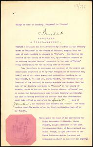
From Archives New Zealand R24773115 - First page of the 1908 proclamation and seal of the Governor-General, changing the name of the town Wainono to Norton.
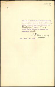
From Archives New Zealand R24773115 - Second page of the 1908 proclamation and seal of the Governor General, changing the name of the town Wainono to Norton.
1908 - Designation of Districts Act 1908
In 1908 the 1894 Designation of Districts Act was updated with minor changes, such as replacing all instances of ’the colony’ with ’New Zealand’.
At the same time a Nomenclature Committee was established. Its job was to review the spelling of Māori names for post and telegraph offices and railway stations. However, the committee only met four times that year before disbanding. The sub-Committee Chairman wrote in their final report to the Nomenclature Committee of ‘the almost impossibility to obtain authentic information of the historical significance of certain words, their origin in many cases being buried in the dust and doubt of ages.’
Designation of Districts Act 1908
The updated 1908 Act was used for 38 years until it was replaced by the New Zealand Geographic Board Act 1946. Over those 38 years, 32 decisions were made to officially assign or change place names.
As with the 1894 Designation of Districts Act, public notices of any proposed name changes were required to 'be affixed and kept affixed at all the post-offices, public schools, Magistrates' Courts, and police-offices within the district or area to be affected...'
This item, printed on cloth, appears to be one of the public notices to 'be affixed and kept affixed'. It announces that Pembroke is changed to Wanaka. This was the last decision made under the Designation of Districts Act 1908, before it was replaced by the New Zealand Geographic Board Act 1946.
From Archives New Zealand R14989624 - Cloth flyer advertising the change from Pembroke to Wanaka in 1940
The Wanaka Islands Domain Board proposed changing Pembroke, which had originally been given in honour of the 13th Earl of Pembroke. The Board considered the name to be unsuitable and irrelevant.
Pembroke was part of a theme of names in the area, with Newcastle and Gladstone having been named for the Earl’s trustees. However, by this time Newcastle had already fallen out of common use and been replaced by the more popular Albert Town. Gladstone was only a 'town on paper', having been surveyed and depicted on maps, but not existing in reality.
The Lake County Council agreed to the proposal and resolved on 20 October 1937 to officially request the change. The proposal was sent to the Honorary Geographic Board, which had been established in 1924, and it unanimously agreed to rename Pembroke to Wanaka. The Governor-General then proclaimed that Wanaka would come into effect on 1 September 1940.
To mark the transition, a ceremony was held during the annual Wanaka Golf Club tournament. A coffin for 'Pembroke' was carried around the hall before midnight, with the 'newborn Wanaka' brought in at the stroke of twelve.
See CENTRAL OTAGO, Otago Daily Times, Issue 24400, 11 September 1940, Page 12
1924 - Honorary Geographic Board of New Zealand established
The Minister of Lands established the Honorary New Zealand Geographic Board on 29 August 1924 on the recommendation of the then Surveyor-General. The Board was to advise on place naming issues, such as a recent proposal to change the name of Wilmot Pass and repeated requests from 'loyal subjects' to change ‘Alien’ German and Austro-Hungarian names.
The proposed duties of the new Honorary Board were:
- To adopt rules for the orthography of geographic names
- To examine cases of doubtful geographical spelling and nomenclature.
- To investigate and decide the priority of the discovery of any geographical feature and recommend the name to be retained.
- To collect original Māori place-names.
- To consider the desirability of substituting British for Alien names appearing on the maps.
- To investigate and decide upon any proposed alteration of a geographical name.
This is the first page of the minutes from the Honorary Board's first meeting.
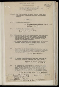
From the Board Archives - Correspondence Volume 2 f.16-22 - Minutes of the First Meeting of the Honorary Geographic Board, held 12 September 1924 at the Surveyor-General's office.
At its first meeting on 12 September 1924 the Honorary Board addressed procedural matters, such as electing a chair, appointing an honorary secretary, deciding on a quorum and adopting some provisional rules which were based on the Canadian Rules of Nomenclature. Most of the meeting was focused on the proposal to change Wilmot Pass to Murrell Pass. The Board decided to keep Wilmot Pass following a detailed examination of the name’s history.
1940 - Centennial Atlas
In 1937 the New Zealand Government began plans to celebrate the 100 year anniversary of the signing of the Treaty of Waitangi. The anniversary would be celebrated in 1940.
The plans included publishing a collection of 88 maps to be called the Centennial Atlas. The maps were to tell the story of ‘development and progress of the nation’. This would include 17 Māori focused maps such as migration from the Pacific, relatively large-scale maps up and down the country, and representation of New Zealand’s landscape and human settlement between 1800-1840.
The Honorary Geographic Board was involved in gathering, researching, and vetting place names for each map in the atlas, particularly the Māori names. The naming experts of the day, such as Sir Āpirana Ngata and Johannes Andersen, decided that all the Māori names would be correctly written in what they termed ‘Classical Maori’ rather than whatever forms were in current use.
World War II interrupted the atlas’ production. People working on the maps died in the war and paper became scarce and more expensive. By 1940 it was already clear that the atlas wouldn’t be completed. Newspaper articles in the 1950s demanded an explanation and an inquiry. Many people who had paid subscriptions for the atlas 12 years earlier had since passed away.
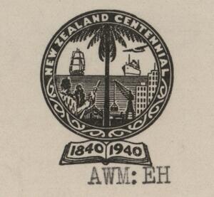
Seal - from Board Correspondence Volume 15 f.195 - Memorandum from A.W. Mulligan to Geographic Board Secretary, R.G. Dick, dated 9 August 1939.
This is the seal of the Centennial Atlas project. On the left a Māori warrior stands before a wharenui holding a taiaha as a tall ship sails over the horizon toward the shore. On the right, 100 years later, a steam ship and aeroplane approach a coastal city with multi-story buildings and a large crane at a loading dock.
Map - from Alexander Turnbull Library: MapColl-832ecde/1840/Acc.26084 - https://tiaki.natlib.govt.nz/#details=ecatalogue.136612
This photo is from part of a draft map for the atlas being the 'Tainui Area as in 1840' drawn by Pei Te Hurinui Jones. The 'Principal Tribal Battle Fields are shewn and dates of battles, where known, are given’. For example, at Kawhia Harbour 'Te Arawi (1820)' refers to when Ngāti Toa under Te Rauparaha were besieged by Ngāti Maniapoto and Waikato under Te Rangituatea.
1946 - New Zealand Geographic Board established under the New Zealand Geographic Board Act 1946
The New Zealand Geographic Board was established under the New Zealand Geographic Board Act 1946. Place naming powers in the 1946 Act included collecting original Māori place names and a 1998 amendment encouraged their use on official maps and charts.
New Zealand Geographic Board Act 1946
From Archives New Zealand R490635 - Signed Copies of Assented Acts - Public 1-46; local 1-13; private 1-4 (New Zealand Geographic Board Act 1946 is Public No. 3) - Copy of the New Zealand Geographic Board Act 1946 as signed on 9 August 1946 with the Royal Assent by Governor-General Lieutenant-General Sir Bernard Cyril Freyberg
The 1946 Act constituted the New Zealand Geographic Board as an independent statutory board with the power to make place names official. Its predecessor, the Honorary Geographic Board, had made rulings and given advice over its 22 years but didn’t have the power to make place names official, it could only make recommendations. This is seen by its many attempts to restore the Wellington place name Kaiwharawhara from 'that distortion' and 'admitted perversion' Kaiwarra, without much success.
Newspapers noted the easy passage of the Bill and speculated whether parliamentarians intended to immortalise themselves in the names of peaks throughout the country.
While one article in the Timaru Herald thought it 'improbable that the Geographic Board will ever engage in a debauch of name changing', others were concerned that with its newfound power the Board would immediately set off to remove all possessive [s]'s in place names. This speculation followed the ongoing Arthur's Pass saga. Multiple newspapers predicted that Palmerston or Palmerston North would soon be on the Board's chopping block due to their similar names.
The Act was similar to the Designation of Districts Act 1908 which it replaced, merging the functions and duties of the preceding Honorary Board, including those around the collection of original Māori names. However, it also included a new rule that the public be consulted when a place name was proposed.
1956 - Board gains the ability to name features in Antarctica
In 1956 the Government gave the Board the ability to name features within New Zealand’s area of interest in Antarctica. This was later formalised under the New Zealand Geographic Board (Ngā Pou Taunaha o Aotearoa) Act 2008.
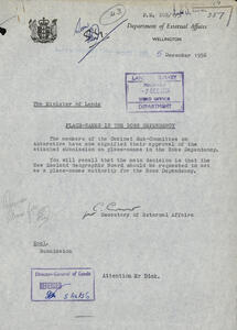
Originally from Lands and Survey File 17/357/1 (Antarctic place names), now at Archives New Zealand R3950090 - Advice from the Secretary of External Affairs to the Minister of Lands 5 December 1956 - Cabinet Sub-Committee approves the New Zealand Geographic Board as a place-names authority for the Ross Dependency.
Preparations began in 1956 for the International Geophysical Year (IGY) 1957-1958 which would cover scientific study of Antarctica. The Commonwealth Trans-Antarctic Expedition lead by Sir Edmund Hillary and Sir Vivian Fuchs was planned and a site was selected for New Zealand's first Antarctic base, Scott Base, which opened 20 January 1957.
In anticipation of the massive programme of exploration, surveying and mapping which would result in new place names, in late 1956 it was recommended that the New Zealand Geographic Board assume the role of place naming authority for the Ross Dependency – New Zealand’s claim in Antarctica. While this section of Antarctica is under New Zealand’s jurisdiction, the Board could previously only name places within New Zealand itself.
This role was approved by a Cabinet Sub-Committee on 5 December 1956.
The Board adopted the recently developed Australian instructions to surveyors to provide a framework to all those heading south. It set out methods for accurately recording and officially approving place names and a process for liaising with Great Britain, Australia and the United States of America. New Zealand was joining countries which had already reached some 'general agreement' on matters of place naming.
As a baseline for the existing names in the Ross Dependency, Arthur Helm, Secretary of the Ross Sea Committee had already been working on a Gazetteer. In its new authority, the Board co-opted both the Gazetteer, seeing the Provisional Gazetteer of the Ross Dependency through to publication in 1958, and Arthur, appointing him Secretary of the newly established New Zealand Antarctic Place Names Committee at its 20 June 1958 meeting.
1988 - Māori name Ngā Pou Taunaha o Aotearoa adopted
On 20 December 1988, the Minister of Lands, Hon. Peter Tapsell, approved the Board's Māori name Ngā Pou Taunaha o Aotearoa. This describes place names metaphorically as ‘memorial markers of the landscape’.
At the Board's 1 August 1988 meeting, Professor Hirini Moko Mead put forward a resolution that the Board adopt the Māori name Ngā Pou Taunaha o Aotearoa. The Board agreed. William (Bill) Robertson, Director General and Surveyor-General of the Department of Survey and Land Information (DOSLI) followed with this memorandum to the Minister for Survey and Land Information asking for approval. It was granted on 20 December 1988:
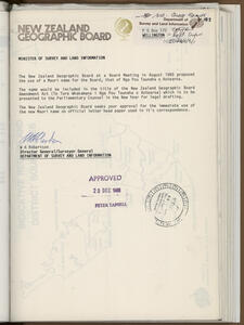
From NZGB Correspondence file 22/2605/3 Volume 14, f.185 - Scan of memo from William Robertson, Director General and Surveyor General of the Department of Lands and Survey, to Minister for Survey and Land Information requesting approval for immediate use of Maori name Ngā Pou Taunaha o Aotearoa on letterhead.
Many years later in 2002, Māori place names researcher Te Aue Davis (1925-2010) would explain that the name was originally determined by Sir James Hēnare.
The Board's Māori name was agreed in the context of an Amendment Bill to modernise the New Zealand Geographic Board Act 1946. The proposed New Zealand Geographic Board Amendment Act (Te Ture Whakamana i Nga Pou Taunaha o Aotearoa) would have added the new Māori name for the Board, increased membership to improve Māori representation, strengthened requirements around collecting original Māori names with reference to the Treaty of Waitangi, and included other improvements such as confirming naming jurisdiction over Antarctic and undersea feature naming.
However, a busy legislative programme meant that the Amendment Act which passed in December 1988 only added a requirement that proposed and final names be advertised in newspapers. It would be another 20 years before the New Zealand Geographic Board (Ngā Pou Taunaha o Aotearoa) Act 2008 addressed the other concerns and incorporated the Māori name of the Board.
Nevertheless, 'Ngā Pou Taunaha o Aotearoa' came into use in preparation for the 1990 celebrations marking 150 years since the signing of the Treaty of Waitangi. At its 17 March 1989 meeting the Board agreed that both parts of its bilingual name would be shown in equal size. The first use of ‘New Zealand Geographic Board Ngā Pou Taunaha o Aotearoa’ appears in April 1989 correspondence with the 1990 Commission and in the presentation pack for potential sponsors of the Board’s 150-year Treaty celebration publications (see below).
1990 - Place Names of the Ancestors - A Māori Oral History Atlas published
This bilingual book tells the stories of early Māori discoverers, explorers and travellers from the first wave of migration waka, and the place names they gave. Each story has a map showing their journeys and the locations of the places named.
Place Names of the Ancestors - A Māori Oral History Atlas
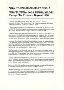
From File CS 16 Maori Oral History Atlas - a page from the sponsorship presentation pack outlining the high level goals of the publications
At the same 1 August 1988 meeting where the Board agreed to its Māori name, it discussed what it planned to contribute to the 150th celebrations in 1990. It decided on a bilingual 'Māori Oral History Atlas', intended as a taonga for future generations. The Board had already made significant progress on the groundwork having gathered support from Māori leaders nationally and made some progress on the content with potential stories. The atlas was to be accompanied by a smaller 'Māori Nomenclature volume' (published as Ngā Tohu Pūmahara Survey Pegs of the Past) and a Māori place names database (which would instead become a New Zealand place names’ database, although not as part of the 150-year celebrations).
The Department of Survey and Land Information (DOSLI) agreed to supply half of the total funding and following its 1 August 1988 meeting the Board prepared funding applications and presentations. In January 1989 the New Zealand 1990 Commission, established to coordinate and fund projects for the 150th, approved $50,000 towards the Māori Oral History Atlas and $24,300 for the Māori Nomenclature volume. However, this left an estimated $75,000 shortfall. The Lotteries Commission then came on board as the major sponsor. The Māori Oral History Atlas was successfully published in early October 1990, shortly followed by the Survey Pegs of the Past handbook.
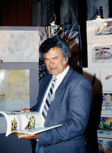
Photo of Cliff Whiting from the Office of the Surveyor-General's photo collection
This photo is of the artist Clifford (Cliff) Hamilton Whiting (1936-2017), who illustrated the Board's two 1990 publications. He later also contributed artwork to the Board's maps of 'The Land and it's People circa 1840', published in 1995.
Here Cliff is attending the 16 October 1990 launch of He Korero Pūrākau Mo Ngā Taunahanatanga A Ngā Tūpuna - Place Names of the Ancestors - A Māori Oral History Atlas. He holds a copy of the book open at the story of Kahupeka and his original pen and coloured ink illustrations are on display behind him. The launch was a modest affair held in the foyer at Parliament.
The Māori Oral History Atlas has remained popular and has been reprinted twice. Cliff Whiting's iconic illustrations have taken on a life of their own, being frequently requested and reproduced for educational resources.
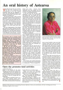
Photo of Te Aue Davis and article in DOSLI Infonews, No.8 April 1990.
This article was published in the No. 9 April 1990 edition of DOSLI's newsletter InfoNews. It is an interview with Te Aue Davis on upcoming publication of He Korero Pūrākau Mo Ngā Taunahanatanga - Place Names of the Ancestors - A Māori Oral History Atlas.
On suggestion of Board member Tipene O'Regan, Te Aue Davis (Ngāti Maniapoto) was hired by DOSLI as Māori researcher for the Board's contributions to the 1990 celebrations. To compile the stories and place names in the publication, Te Aue Davis delved into historical records and existing publications and travelled the country to meet with Māori knowledge holders to verify everything to be included.
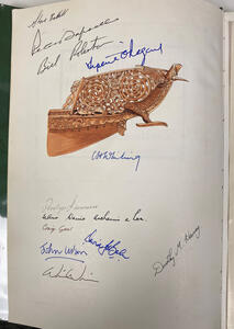
Steve Brettell's signed copy of the Oral History Atlas
This first edition hardback copy of He Korero Pūrākau Mo Ngā Taunahanatanga A Ngā Tūpuna - Place Names of the Ancestors - A Māori Oral History Atlas belongs to former DOSLI cartographer Steve Brettell, who produced the maps with fellow cartographer Craig Gear. Steve got many of the key people involved in the publication to sign his copy of the book.
From top to bottom:
- Steve Brettell - Cartographer, DOSLI
- Peter Tapsell - Minister of Survey and Land Information
- [William] Bill Robertson - Surveyor-General and Director General of DOSLI and Chair of the Board
- Tipene O'Regan - contributor and author of introduction
- Cliff Whiting - artist and illustrator
- Penelope Lawrence - Secretary of the Board
- Te Aue Davis - Māori researcher and compiler of the book
- Craig Gear - Cartographer, DOSLI
- David Balm - Map editor, DOSLI
- John Wilson - Historian and Editor
1995 - New maps of Tangata Whenua place names launched
At the 1990 South Pacific Place Names Conference in Wellington (which the Board had organised for the 150th), it was decided to produce a map of original Māori place names. The Board decided it would complete the 1940 centennial maps as part of the upcoming 1993 International Year for the World’s Indigenous People. The Board retrieved the existing scholarship from the Centennial Atlas and added further original Māori names. For the cartography, vegetation ~1840 was sourced from the New Zealand Atlas 1976 and review of scientific papers.
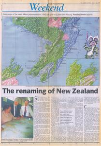
Review and interview 'The renaming of New Zealand' published in the Dominion Weekend on 1 July 1995.
The Board's maps of Te Ika a Māui and Te Wai Pounamu were launched on 26 June 1995. This review and interview 'The renaming of New Zealand' was published a week later in the Dominion Weekend on 1 July 1995. The author expressed some concern about the coverage of names and whether or not they meet the 'circa 1840' byline in the maps’ titles. Te Aue Davis, the Board's Māori researcher responded that the names that made it on to the map were the most well researched and enduring ones.
For the full story behind the maps see:
Maps of Te Wai Pounamu and Te Ika a Māui - first edition 1995
2008 - New Zealand Geographic Board (Ngā Pou Taunaha o Aotearoa) Act 2008
On 1 November 2008, the New Zealand Geographic Board (Ngā Pou Taunaha o Aotearoa) Act 2008 came into force.
The 2008 Act extended the Board's responsibilities to include naming undersea features to the limits of New Zealand’s continental shelf, naming Department of Conservation reserves, and formalised place naming in Antarctica. It also recognised the Crown’s responsibility to take appropriate account of the Treaty of Waitangi.
New Zealand Geographic Board (Ngā Pou Taunaha o Aotearoa) Act 2008
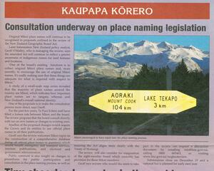
From Board file BRD/02/00/15/ZNO-04 - Call for submissions, published in Te Puni Kōkiri's newsletter Kōkiri Paetae, December 2003.
This article was published in the Te Puni Kōkiri magazine Kōkiri Paetae in December 2003. It details the impending review of the New Zealand Geographic Board Act 1946 and calls for feedback. This notice was at the start of the legislative review process which would take place over several years. Some of the questions posed in the review were on how the Board might better encourage Māori participation and the role that Te Puni Kōkiri might have in the process.
Read the Summary and Analysis of Submissions for the Review of the New Zealand Geographic Board Act 1946.
2013 - Te Ika-a-Māui North Island and Te Waipounamu South Island made official alternative names for our two main islands
In 2013 Te Ika-a-Māui and Te Waipounamu were made official alternative names for the North Island and South Island respectively, which also became official. Prior to this, the English names of the islands had not been official and the Māori names had stopped being used on official maps.
Te Ika-a-Māui North Island and Te Waipounamu South Island
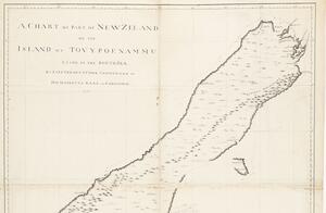
A Chart of Part of New Zeland or the Island of Tovypoenammu, Lying in the South Sea by Lieutenant J. Cook Commander of His Majestys Bark the Endeavour, 1770 - Mitchell Library, Sydney. Bibliography of Captain James Cook, 858
2023 - Second edition of the Tangata Whenua place name maps launched
The second edition of the maps improved on the first edition with corrections, the addition of original names restored by Treaty of Waitangi settlements, and names resulting from direct consultation with iwi and hapū. For Te Waipounamu, names were comprehensively reassessed after decades of additional research by Te Rūnanga o Ngāi Tahu on its cultural heritage, as published in its online atlas Kā Huru Manu.
Maps of Te Waipounamu and Te Ika-a-Māui - second edition 2023
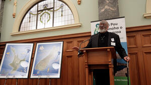
Photo of Shane Te Ruki, serving as MC for the 3 July 2023 launch at Parliament's Grand Hall.
Here former Board member Shane Te Ruki (Ngāti Maniapoto) speaks at the 3 July 2023 launch of the Board’s second edition Tangata Whenua maps. It was held in the Grand Hall at Parliament and attended by the Board, Minister for Land Information, Toitū Te Whenua Land Information New Zealand staff and special guests including iwi and hapū representatives who had shared their names and kōrero with the Board. An unveiling ceremony was held for the new editions. They were displayed side by side with the first edition 1995 maps for comparison.