Two previously uncharted shipwrecks have now been mapped in great detail thanks to a recent hydrographic survey of Tūranganui-a-Kiwa/Poverty Bay.
Toitū Te Whenua Land Information New Zealand (LINZ) is the government agency responsible for providing navigational products and services that support safe shipping. The information underpinning these products is captured through hydrographic surveys that map the seafloor.
The recent survey of the Gisborne area uncovered the hull and deck structure of the Star of Canada, which ran aground off Kaiti Beach on 23 June 1912, and the wreck of a barge used to dredge Napier and Gisborne harbours in the 1930s.

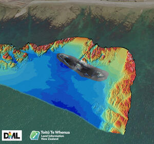
3D image of the Star of Canada wreck captured through echosounding with Eastland Port in the distance.

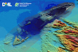
3D image of the Star of Canada wreck captured through echosounding.
“It’s always satisfying when our surveys reveal features that were either unknown or uncharted,” says LINZ Principal Geospatial Specialist Stuart Caie.
“Advances in technology mean that each time we resurvey an area we uncover details that were previously unknown. In this case, the last survey was done in the 1950s by the Navy and the echosounding technology used this time has given us far greater coverage of the seafloor than ever before. While the local community is aware of these wrecks, they have never been charted.”
The 7280-ton steamer Star of Canada first voyaged to New Zealand in 1910. For the next two years it regularly travelled from Australia and New Zealand to England, carrying chilled and frozen meat and other produce.
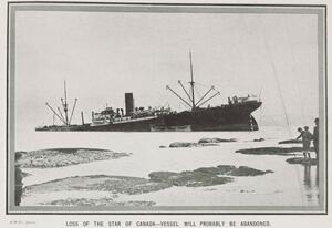
On 23 June 1912, a southerly squall blew the vessel onto Kaiti Beach where it struck rocks and began taking in water. Despite attempts by the local tug, Hipi, the Star of Canada grounded just off the rocky shoreline. No lives were lost but after days of effort, the vessel itself was abandoned.
You can learn more about the Star of Canada on the Tairawhiti Museum website.
The Star of Canada - Tairawhiti Museum

The Star of Canada – still above water but in the process of sinking.
Image credit: Auckland Libraries Heritage Collections NZG-19120710-0027-01.
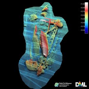
The second wreck is the remains of the dredge Korua, which are off Young Nick’s Head. The dredge was scuttled in 1940 when it was no longer of use.
Data captured in the Gisborne hydrographic survey, including details of the two wrecks, will be used to update nautical charts of the area and help to make navigation safer.
While the survey focused on data needed to update navigational charts, hydrographic surveys also gather information that can help with marine habitat management, aquaculture developments, flood planning and research.
Data from the survey will be published on the LINZ Data Service website and updated nautical charts will be available from the free NZ Electronic Navigational Chart Service

3D image of the dredge Korua in pieces on the seafloor.
Media contact
Email: media@linz.govt.nz