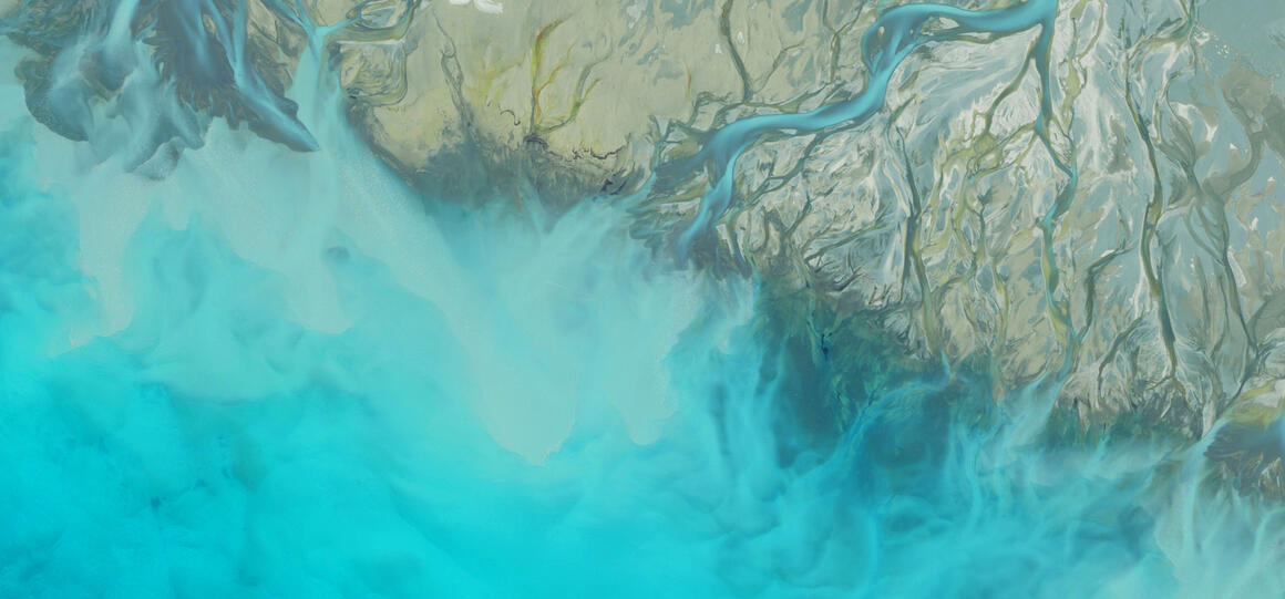
[Jump to content]
  • Toitū Te Whenua Land Information New Zealand
  • LINZ Data Service
  • Geodetic Database
  • Landonline
Toitū te Whenua Land Information New Zealand. Click to open menu Menu
  • About us
  • Consultation
  • Contact us
  • Land
  • Sea
  • Data
  • Crown Property
  • Regulatory
  • Overseas investment
  • News
    • Overseas Investment news
    • Crown Property news
    • LINZ Data Service news
    • Corporate news

    News

  • Information for...
    • Surveyors
    • Lawyers and Conveyancers
    • Local Government
    • Māori and iwi
    • Property Owners and Investors

    View all information for...

Defining ‘where’ - through maps, surveys and titles. More about Land

  • Maps
    • Where to find maps and data
    • Topographic maps
    • Search map retailers
  • Land records
    • Search for and order a land record
    • Types of land records
    • Search for land records
    • Correct a land record
  • Land registration
    • Prepare and submit your dealing
    • Pre-validation and avoiding errors
    • Manual dealings
    • Land registration user guides and resources
    • Standards, directives and guidelines
    • The land transfer system
    • Land Transfer Act 2017
    • Revoked Standards, Guidelines and Rulings
    • Trusts Act 2019 information
  • Surveying
    • Cadastral Survey Rules 2021 (CSR 2021) Implementation
    • The survey system
    • Rules, standards and guidelines
    • CSD preparation
    • Landonline Requests - Survey
    • CSD lodgement and approval
    • TA e-certification
    • Earthquakes
    • Local tie surveys in New Zealand
  • Landonline
    • Landonline Web Search
    • Authority and Identity Requirements and Electronic Signing of Documents Interim Guideline 2020 – 30 March 2020
    • Open a new Landonline account
    • Add a user or change your details
    • Digital certificates and security
    • System support and software downloads
    • Landonline releases and system updates
    • e-Search
    • Fees
  • News
  • KnowledgeBase
  • Regulatory Search

Keeping you safe at sea.More about Sea

  • Charts
    • NZ Chart Catalogue Spatial View
    • NZ Chart Catalogue List View
    • Information about charts
    • Annual work programme
    • Standards and technical specifications for our chart and hydrographic work
    • NZ ENC Service
  • Maritime safety
    • Notices to Mariners
    • Report a Hazard to Navigation - H Note
    • New Zealand radio navigational warnings
    • Safety at sea
    • Improving maritime safety in the Pacific
  • Nautical information
    • New Zealand Nautical Almanac (NZ 204)
    • List of lights
    • Maritime boundaries
    • Astronomical information
  • Tides
    • Introduction to tides
    • Tidal streams
    • Sea level data
    • Tide predictions
  • Marine geospatial information
    • The NZ Marine Geospatial Information Working Group
    • Finding and accessing MGI
    • Managing and reusing MGI
    • Understanding hydrographic data
    • Marine scientific research
    • Nippon Foundation-GEBCO Seabed 2030 Project
  • News
  • KnowledgeBase
  • Regulatory Search

Helping you find, use and share location information.More about Data

  • LINZ Data Service
    • Register for the LDS
    • Getting started with LDS
    • LDS APIs and web services
    • Guides and documentation
    • LINZ Data Service FAQs
  • LINZ data
    • Hydrographic data
    • Geodetic data
    • Property, ownership and boundary data
    • Road, address and places data
    • Crown land data
    • Aerial imagery
    • Topographic data
    • Elevation data
    • Resilience and climate change
    • Central Record of State Land
    • LINZ Basemaps
  • Licensing and using data
    • Attributing LINZ data
    • Attributing elevation or aerial imagery data
    • LINZ Licence for Personal Data
    • LINZ Licence for Pending Approval Data
    • Government agencies access to properties data
  • Geospatial data types - general guidance document
  • Geodetic services
    • Search for geodetic marks
    • Download geodetic mark data
    • PositioNZ
    • Coordinate conversion
    • Download geodetic software
    • Geodetic Marks App
    • Privacy policy for the Geodetic Marks App
    • Satellite-based augmentation system
  • News
  • KnowledgeBase
  • Regulatory Search

Making best use of the Crown Estate.More about Crown Property

  • Crown Property engagement
    • Client agency property management and disposals
    • Client agency strategic asset management
  • Types of Crown property
    • Apply for property interests over coastal reclaimed land
    • Crown forest land
    • Lakebeds and riverbeds
    • Crown pastoral land
    • Camping areas
    • Christchurch residential red zones
    • Projects and hazard management
    • Treaty Settlements Landbank and the Māori Protection Mechanism
  • Crown pastoral land
    • Crown pastoral land management
    • Pastoral leases and licences
    • Status and location of Crown pastoral land
    • Tenure review
    • Lease rent review
    • Applying for pastoral consents
  • Using Crown property
    • Leases and licences
    • Mining
    • Easements
    • Commercial activities
    • Biosecurity and biodiversity
  • Acquisition and disposal of land
    • Acquisitions for public works
    • LINZ's Role in Treaty Settlements
    • Right of First Refusal (RFR)
    • Accredited Crown Property service providers
    • Protection of Values on Crown-owned Land
    • Crown property disposals
    • Land acquisitions for Christchurch anchor projects
  • News
  • KnowledgeBase
  • Regulatory Search

Land regulations and those who oversee them.More about Regulatory

  • Regulatory stewardship and strategy
    • Our regulatory systems
  • Place names
    • Propose a place name
    • Find a place name
    • Place name consultation
    • Make a submission on a place name proposal
    • Approving recorded (unofficial) place names as official
    • Recent place name decisions and place names of interest
    • About the New Zealand Geographic Board
    • WW1 through place names
    • Tuia – Encounters 250
  • Property addressing
    • Addressing roles and responsibilities
    • Addressing standards and guidelines
  • Valuation
    • Property valuation in New Zealand
    • Audits of rating valuations
    • Valuers Registration Board
    • Valuation rules, guidelines and publications
    • Review of the Occupational Regulation of Valuers
    • Guidelines for General Revaluation deferral
  • Regulatory Search
    • Search for Standards
    • Search for Guidelines
    • Search for 'Cadastral'
    • Search for 'Geodetic'
    • Search for 'Land titles'
    • Search for 'Crown property'
  • News
  • KnowledgeBase
  • Regulatory Search

Ensuring New Zealand benefits from overseas investmentMore about Overseas Investment

  • Discover
    • Find out if you need consent
    • Exemptions
    • Find out if you need to notify us of your transaction
    • Our investment pathways
    • Our assessment process
    • Overseas investment tests
    • OIO fees and penalties
    • What we do
    • Variations to consent or conditions
    • Glossary of overseas investment terms
  • Apply
    • Notify the Overseas Investment Office of a transaction
    • Before you apply
    • Apply for consent, variation or exemption
    • Notify us of a transaction made under a standing consent
  • Sell
    • Selling to an overseas person
    • Vendor information form
    • Farm land advertising
  • Comply
    • Our compliance approach
    • Submit a compliance report
    • Apply for retrospective consent
    • Report a suspected breach
  • Latest
    • Changes to the overseas investment legislation
    • News
    • News from the Overseas Investment Office
    • Pānui and OIO Reform newsletters
    • Latest decisions
    • Enforcement action taken
  • News
  • KnowledgeBase
  • Regulatory Search
  • Back KnowledgeBase

You are here

  1. Home
  2. KnowledgeBase

KnowledgeBase

  • Share this
  • Share on Facebook.
  • Share on Twitter.
  • Share on LinkedIn.

The Knowledge Base provides access to detailed information around the property transaction and survey process, and the Landonline application.

Find information and articles by searching using title or keywords, alternatively browse by topic area.

If you can’t find what you are looking for use the site-wide search. Rules, standards and guidelines can also be found using the regulatory search.

Search criteria
Or filter by Criteria
  • Boundaries defined by survey

    The following information relates to defining by survey boundaries and boundary points under rule 6.2.

    • Surveyor-General Guidelines (RCS 2010)
    • Updated: 12 November 2018
  • Movable Marginal Strips - capturing in Landonline

    The government requires that all Crown agencies that dispose of Crown land require the marginal strips to be included as part of the survey and be included in the resultant CSD.

    • Survey
    • Updated: 1 July 2019
  • Use of non-NZGD2000 bearings

    The following information relates to the circumstances where non-NZGD2000 bearings (including old cadastral, NZGD1949 and magnetic bearings) may be used in a CSD.

    • Surveyor-General Guidelines (RCS 2010)
    • Updated: 6 April 2017
  • Capturing an Accretion parcel

    This article contains information on capturing Accretion parcels.

    • Survey
    • Updated: 12 November 2018
  • Parcel Intent Usage

    Landonline Parcel Intents – Definition and Usage

    • Survey
    • Updated: 11 October 2021
  • Accuracy of boundary witnessing

    The following information relates to rule 3.6 and the accuracy requirements that apply between witnessed boundary points and non-boundary marks on a cadastral survey.

    • Surveyor-General Guidelines (RCS 2010)
    • Updated: 29 March 2017
  • Accuracy of right-line and arc boundaries

    The following information relates to rule 3.3.1 and the accuracy requirements for boundary points on right-line and arc boundaries that are defined on a cadastral survey.

    • Surveyor-General Guidelines (RCS 2010)
    • Updated: 7 February 2019
  • Legalisation CSDs - incorrect parcel intent being used

    There have been a number of requisitions recently for incorrect parcel intent captured for legalisation CSDs.

    • Survey
    • Updated: 12 August 2011
  • Boundaries defined by adoption

    The following information relates to defining by adoption existing boundaries under rule 6.4 including what this term means, the duty of a surveyor when a right line, irregular or water boundary is defined by adoption, and the accuracy standards that apply.

    • Surveyor-General Guidelines (RCS 2010)
    • Updated: 31 March 2017
  • Recording estate boundaries

    The following information relates to recording an estate boundary and its associated estate record references in a CSD.

    • Surveyor-General Guidelines (RCS 2010)
    • Updated: 31 March 2017

Pages

  • « first
  • ‹ previous
  • 1
  • 2
  • 3
  • 4
  • 5
  • 6
  • 7
  • 8
  • 9
  • next ›
  • last »

Browse by Land registration topic

  • Caveats
  • Compliance
  • Consents
  • Easements
  • Gazette notices
  • Identity
  • Instruments
  • Leases
  • Māori land
  • Mortgages
  • Powers of attorney
  • Requisitions
  • Subdivisions
  • Transfers
  • Transmissions
  • Urgency

Browse by Survey topic

  • Appellations
  • Capture
  • Irregular boundaries
  • Linking
  • Non-primary parcels
  • Primary parcels
  • Requisitions
  • TA certification
  • Vectors
  • Water boundaries

Popular articles

  • Instruments
  • Authority and Instruction (A&I)
  • Citrix Receiver download and installation
  • UniPrint client download and installation
  • Subdivisions
  • Search for a title

Recent updates

  • Landonline user access types | 17 June 2022
  • Requests to process a transaction with urgency | 10 June 2022
  • Landonline software requirements | 8 June 2022
  • Landonline internet and network requirements | 23 May 2022
  • Firewalls and proxy server configuration - 1 year Digital Certificates | 18 May 2022
  • Firewalls and proxy server configuration - 2 year Digital Certificates | 18 May 2022

Global footer

Information for...

  • Information for surveyors
  • Information for Local Government
  • Information for property owners and investors
  • Information for lawyers and conveyancers
  • Information for Māori and iwi

Popular content...

  • Search for and order a land record
  • Tide predictions
  • Official Information Act Requests
  • Consultation
  • Publications

About this site...

  • About this website
  • Toitū Te Whenua copyright
  • Privacy
  • Accessibility
  • Feedback on this site
  • Contact us
  • Careers
  • Site map
  • Follow us
  • Follow on Facebook
  • Follow on Twitter
  • Follow on Linked In
  • Follow on Youtube

Copyright and disclaimer

New Zealand Government