The International Terrestrial Reference Frame (ITRF) needs an accurate connection between the reference points of the geodetic infrastructure. This connection is referred to as a local tie. The difficulty is that a reference point may not be a physical point or able to be physically occupied.
New Zealand’s connection to the ITRF
New Zealand hosts 3 of the 4 connection techniques: the global navigation satellite system (GNSS), doppler orbitography radiopositioning integrated by satellite (DORIS) and very long baseline interferometry (VLBI). Due to New Zealand's geographical location and the space geodesy infrastructure in the Southern Hemisphere, these connections are valuable to the ITRF.
There is an opportunity for New Zealand to improve its connection to the future ITRF realisation through the addition of VLBI observations collected at Warkworth. The 12m radio telescope (WARK12M) was established in 2008. Prior to 2008 New Zealand supported the ITRF predominantly through GPS by operating a network of international GNSS Service (IGS) stations, with the exception of the DORIS beacon which has had a station located on the Chatham Islands since 2007.
WARK12M is undertaking regular campaigns as part of the Australasian Geodetic VLBI Network (AuScope) and is fully integrated into the global international VLBI service (IVS). In 2009 LINZ and GNS Science established a continuously operating reference station (CORS), WARK, at the observatory. It has since been added to the IGS network. This work will continue to improve the definition of future ITRFs in the south-west Pacific which supports the maintenance and enhancement of New Zealand’s national datum through more accurately defined products. In 2014 the 30m telescope also became VLBI capable.
The national datum, New Zealand Geodetic Datum 2000 (NZGD2000) is nominally aligned with ITRF96 at epoch 2000.0.
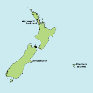
Warkworth and the Chatham Islands are the two locations within New Zealand that have collocated infrastructure.
Warkworth Radio Astronomical Observatory

The 30 metre radio telescope in the foreground with the 12 metre telescope in the background to the right
The Warkworth Observatory is 60km north of Auckland. The site is operated by LINZ and SpaceOps NZ.
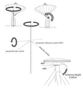
The surveys are to determine the relationship between the antenna reference point (ARP) of the permanent GNSS CORS site (WARK 50243M001), the invariant reference points (IVP) of the 12 metre (7377 50243S001) and 30 metre (7391 50243S002), VLBI capable radio telescopes. The IVP is defined as “the intersection of the primary axis (i.e. fixed axis), with the perpendicular vector between the secondary axis (i.e. moving axis) and primary axis” (Dawson, Sarti, Johnston, & Vittuari, 2007). Internationally the local tie vector is expected to better than a 3mm accuracy. The IVP is determined by observing prisms fixed to the telescope and independently rotating it around its two axes from two stand points.
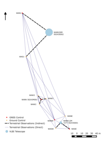
Warkworth terrestrial network showing connections to infrastructure
To avoid disturbing the GNSS antenna, the station's position was also determined using indirect terrestrial survey techniques from 3 reference marks located equidistant around the GNSS station.
Owenga, Chatham Islands
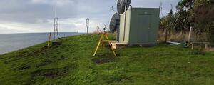
The DORIS beacon (OWFC) and the REGINA GNSS station (OWMG)
The Chatham Islands, 840km east of Christchurch, hosts a DORIS station and GNSS station which are both integrated into the International DORIS Service (IDS) and IGS respectively. Both stations were re-located in 2015 from the site approximately 200m from the current location.
The survey was to determine the height of the GNSS antenna and DORIS beacon above their ground marks and determine the relationship between the two. This survey was completed by LINZ in 2016.
Similar to the Warkworth survey, the DORIS beacon and GNSS antenna had to be observed using an indirect method. Three reference marks were installed around the site in order to intersect their horizontal positions.
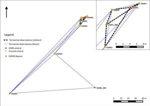
Owenga, Chatham Islands terrestrial network showing connections to infrastructure
New Zealand Local Tie Survey Reports
More information about the surveys can be found in their associated reports.
| Report | Connections |
|---|---|
| WARK (IGS), 7377 (IVS) | |
| WARK (IGS), 7377 (IVS), 7391, | |
| OWMG (IGS), OWFC (IDS), | |
| WARK (IGS), 7377 (IVS), 7391 (IVS) | |
| WARK (IGS), 7377 (IVS), 7391 (IVS) |
References
Dawson, J., Sarti, P., Johnston, G. M., & Vittuari, L. (2007). Indirect approach to invariant point determination for SLR and VLBI systems: an assessment. Journal of Geodesy, 81(6-8), 433–441. https://doi.org/10.1007/s00190-006-0125-x