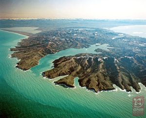
Photo Credit: 92534 – Lloyd Homer – GNS Science | Te Pū Ao – All rights reserved
On 16 February 1770, the HMB Endeavour was sailing down the east coast of the South Island [Te Waipounamu] and Cook described a piece of land ‘seemingly detached from the coast’. At sunrise the following day, he was certain that there was no land between the island and the mainland and named this apparent island after Joseph Banks.
Banks was a young, wealthy naturalist on board the Endeavour. He had financed passage for himself and his retinue, after lobbying the Royal Society (who in turn lobbied the Admiralty) to join the voyage to Tahiti. His group included:
- Dr Daniel Carl Solander, a 34-year-old Swedish botanist
- Herman Diedrich Sporing, Solander’s Swedish assistant
- Sydney Parkinson, a 23-year-old Scottish botanical artist
- Alexander Buchan, a landscape and portrait artist
- Four of Banks’ servants
Cook had rather generously allowed the group to work in the Great Cabin, which was normally reserved for the captain. This large room on the upper deck of the ship was reasonably well lit with windows along the stern. Here Banks’ group dissected, preserved, identified and sketched the plants, fish, insects and animals they had found on shore and in the sea.
Of the nine people in Banks’ group, only four survived the journey. Banks achieved celebrity status upon returning to Britain.
The ‘island’ remained on European maps for four decades. In 1809 the vessel Pegasus surveyed the South Island’s east coast, using maps based on Cook’s work. When the captain tried to sail between Banks Island and the mainland, he discovered the ‘island’ was in fact a peninsula. Banks’ name was given to the peninsula.
References
- NZ Gazetteer - Banks Peninsula
- James Cook, ’17 February 1770’, South Seas: Voyaging and Cross-Cultural Encounters in the Pacific (1760-1800)
- John Gascoigne, ‘Banks, Sir Joseph, baronet (1743–1820)’, Oxford Dictionary of National Biography
- John Wilson, 'Canterbury places - Banks Peninsula', Te Ara - the Encyclopedia of New Zealand