Ross Sea Region Geodetic Datum 2000 (RSRGD2000) is the official geodetic datum used in the Ross Sea region of Antarctica. It allows a 3-dimensional position to be related to a consistent coordinate in the format latitude (Φ), longitude (λ), and ellipsoidal height (H).
A geodetic datum is a reference system that defines how positions are represented. This includes:
- a coordinate system
- a reference ellipsoid
- additional models, such as a deformation model.
RSRGD2000 was implemented in 2000 to replace the Camp Area Datum that had been widely used in areas of the Ross Sea region. Camp Area Datum was established at McMurdo Station though astronomic observations, and provided a local reference point for geodetic datum coordinates. These Camp Area Datum coordinates have been used across the region including remote locations of scientific interest, and for making maps throughout the area.
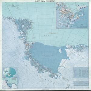
RSRGD2000 includes marks on Ross Island and within a few hundred kilometres of the Antarctic continental coast, including areas of scientific interest or where topographic mapping has been performed. The area covered by RSRGD2000 is indicated in the image below.

Ross Sea, 1:3 Million
There is no deformation model associated with RSRGD2000, so it aligns closely with the GPS datum (World Geodetic System 1984) WGS84. There is usually no need to perform transformation between these 2 datums.
RSRGD2000 is formally defined in the LINZ standard LINZS25001 (Standard for Ross Sea Region Geodetic Datum 2000).
| Name | Ross Sea Region Geodetic Datum 2000 |
|---|---|
| Abbreviation | RSRGD2000 |
| Coverage area | Ross Sea Region between 160° E – 150° W and south 60° S |
| EPSG code | 6764 |
| Coordinate system | Geographic |
| Reference frame | ITRF 1996 |
| Reference ellipsoid | GRS80 |
| Prime meridian | Greenwich |
| Deformation model | No deformation model has been defined |
| Reference date | 1 January 2000 (epoch 2000.0) |