Geodetic marks are used to measure our land, sea and rivers. Surveyors rely on them to determine the location of property boundaries, scientists use them to monitor tectonic movements, and engineers use them to set out building sites. While thousands of these marks exist in New Zealand, many are located below or at ground level and go unnoticed.
Damaged geodetic marks
Toitū Te Whenua is responsible for measuring and maintaining New Zealand’s geodetic marks, including the trig beacons.
Report damage to a geodetic mark
You can also email us at crm_geodetic@linz.govt.nz
Read more about survey mark protection
Trig stations
A trig station (also known as a triangulation station, geodetic mark, or trig) is a geodetic survey mark that surveyors use to form a triangulation network of angles and distances.
Find out about the National Geodetic Adjustment
Toitū Te Whenua publishes the coordinates and elevations of each trig station so they can be used as a physical reference point for surveys.
Find trig stations in the geodetic database
A trig beacon is a structure used to protect the trig, make the station visible from a distance, and provide a well-defined reference point. Not all trig stations have a trig beacon.
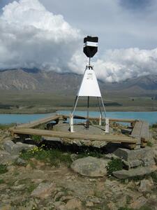
Most New Zealand trig beacons are 2 to 4 metres tall, and are painted black and white. They are often at the top of hills, so that surveyors can easily see them when setting and identifying property boundaries.

A black and white trig beacon, installed at geodetic mark 6702: A MT JOHN. The trig beacon has good visibility across Lake Tekapo and Two Thumb Range.
Trig beacons are also used as a navigational aid. They are often shown on topographic maps and nautical charts, and provide a reference for activities such as tramping.
Continuously operating reference stations (CORS)
A CORS (continuously operating reference station) is a permanent GNSS (global navigation satellite system) station equipped with high-precision receivers and antennas. Toitū Te Whenua operates a network of CORS, known as the PositioNZ network.
These stations track and broadcast their position in real-time, and Toītū Te Whenua records the data collected and stores it in the PositioNZ RINEX Data Archive.
The PositioNZ network connects the national geodetic datums used in New Zealand with the global geodetic reference frames. This means that coordinates measured in New Zealand are consistent with global standards.
CORS are also used to obtain a reference point for applications such as surveying, mapping, navigation and scientific research. CORS sites complement the network of trig stations and are strategically placed to enhance the accuracy and reliability of geodetic survey networks.
The PositioNZ network does not replace geodetic marks in the ground, and trig beacons remain an important part of our survey infrastructure.
Search the geodetic database
Toitū Te Whenua has a database of information about all geodetic marks in New Zealand, our offshore islands, the Chatham Islands and the Ross Sea region of Antarctica.
The geodetic database provides information such as the mark’s:
- coordinate and elevation
- beacons or other protection infrastructure
- location or access diagrams
- site photographs.