About PositioNZ
The PositioNZ network collects Global Navigation Satellite System (GNSS) data, from systems such as GPS (US), BEIDOU (China), GALILEO (EU), GLONASS (Russia) and QZSS (Japan). All data is freely available for reuse under LINZ copyright.
The PositioNZ network is run in partnership with GNS Science through the GeoNet Project. All of the PositioNZ stations are included in the GeoNet network, which monitors natural hazards in New Zealand.
The primary purpose of the PositioNZ network is to monitor the New Zealand Geodetic Datum 2000 (NZGD2000) and provide data which is used to update the national deformation model.
This keeps NZGD2000 aligned with the International Terrestrial Reference Frame (ITRF). Toitū Te Whenua also provides data from 6 PositioNZ sites to the International GNSS Service (IGS), helping to more accurately determine GNSS satellite orbits and positions.
The PositioNZ network allows you to position points with an accuracy of up to a few centimetres both horizontally and vertically, relative to NZGD2000. Toitū Te Whenua provides:
- static GNSS data in the form of RINEX through the PositioNZ RINEX Data Archive
- real-time RTCM streams through PositioNZ-RT
- a post -processing service called PositioNZ-PP.
These products and services are used by surveyors, engineers, geospatial professionals, scientists and commercial providers.
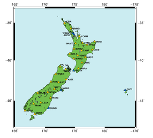
Map of the Toitū Te Whenua PositioNZ network

(Yellow triangles) PositioNZ network in New Zealand and the Chatham Islands, (Blue triangles) PositioNZ International GNSS Service (IGS) stations
Toitū Te Whenua GNSS customer survey results
Customers who subscribe to the GNSS services provided by Toitū Te Whenua may be asked to complete a customer satisfaction survey. Summaries of previous surveys can be downloaded below.