The Crown Aerial Film Library
The Crown Aerial Film Library is a unique and vital record of 72 years of New Zealand history. It preserves, in snapshots, the changes in the national landscape and, by extension, the story of the New Zealanders who lived there.
The Library comprises nearly 700,000 photo negatives from 7,300 aerial surveys flown between 1936 and 2008, as well as contact prints and other associated materials. Photos were captured for a range of purposes, including photogrammetry and topographic mapping, Defence training, land management, and town planning.
The 1,500 rolls of film in the Library are stored in an environmentally controlled vault, to minimise degradation of the film. Photos were captured using a variety of cameras, primarily Eagle, Wild (Leica), and Williamson models. Frame sizes vary from 7x7 inch (18 cm) to 9x9 inch (23 cm).
Photo negatives in the Library were originally held as two separate collections: surveys flown on behalf of the Crown and private surveys flown by New Zealand Aerial Mapping (NZAM). In 2014, LINZ acquired the NZAM collection and added it to the greater Crown Library. All materials currently in the Library are under Crown copyright.
The NZ Aerial Photo Footprints, Mainland NZ, (1936-2005) polygons layer on the LINZ Data Service (LDS) contains metadata for every photo in the Library, as well as records for unscanned Crown surveys. Revisions to this layer, with new error corrections, are published periodically.
Note: Some records do not include footprint polygons.
NZ Aerial Photo Footprints, Mainland NZ, (1936-2005)

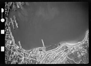
Wellington waterfront, 1953
Scanning the negatives
We commenced scanning the Crown Aerial Film Library in 2014 and completed the project in June 2023. All digitised photos are available as high resolution TIFF images, free of charge, under the Creative Commons Attribution 4.0 International license.
Toitū Te Whenua contracted WSP New Zealand Limited to digitise the photo collection, using specialised, high-resolution photo scanners. Depending on the quality of each film, negatives were scanned at resolutions of either 14 or 21 microns. During scanning, the following information was recorded (if available):
- altitude
- camera model
- date captured
- frame size
- scale
- charts for each survey
- camera calibration files

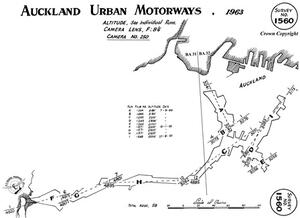
Chart for Survey No. 1560
Accessing the scanned photos
The Retrolens website provides an interactive search interface for viewing and downloading a subset of the photos in the Crown Aerial Film Library. Although these are at a lower resolution than LINZ’s original scans, the downloads are suitable for most general purposes.
All negatives held by LINZ have been digitised if possible. Full resolution scans, survey charts, and calibration files may be requested by emailing imagery@linz.govt.nz with the subject line: “Historical Imagery”. Please provide a spreadsheet with the survey number, run, and photo number for each image required. These details are available in the metadata of the NZ Aerial Photo Footprints, Mainland NZ, (1936-2005) layer.
Note: Historical aerial photos are not available for direct download from the LINZ website or LINZ Data Service at this time. We also do not offer GeoTIFFs or orthorectified historical imagery.
Some Crown surveys — usually numbered between 10500 and 13000 — were flown by Aerial Surveys and they retain the negatives. To obtain copies of these photos, contact Aerial Surveys.