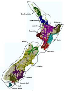
There are 13 official local vertical datums (LVDs) in New Zealand, and many other city or local area vertical datums and assumed height datums have been established as required. These have been established by determining an approximation of mean sea level (MSL), and then transferring this level throughout a benchmark network.
Background
Sea level is not a flat or consistent surface - it varies around the coast and is impacted by weather, currents, salinity and tidal forces. It is also dependent on gravity from the sun and moon, so it takes more than 18 years of observations to measure a full tidal cycle. Most occupations to determine tide gauge reference heights are significantly shorter than 18 years so networks which have been determined using different reference points, or at different reference times, usually have different heights.
The heights on benchmarks are usually determined from very long, and often poorly constrained, precise levelling networks. Others are determined over long distances by vertical angles, allowing any errors to spread and compound. Any land movement or damage to the benchmark is very hard to determine as this requires levelling to a stable benchmark that could be several kilometres away.
Most of the official LVDs were established and measured between 1940 and 1990, using MSL values determined prior to 1960. The heights published by Toitū Te Whenua on survey plans or in the Geodetic Database have not been routinely updated or maintained since they were observed, even though many benchmarks may have moved to some extent during this time.
In contrast, New Zealand Vertical Datum 2016 (NZVD2016) heights are determined in relation to a static and stable reference surface, New Zealand Quasigeoid 2016 (NZGeoid2016). The NZVD2016 benchmark heights are regularly monitored, and because all benchmarks are included in the National Geodetic Adjustment (NGA) the relative consistency between marks can also be maintained.
- New Zealand Vertical Datum 2016 (NZVD2016)
- New Zealand Quasigeoid 2016 (NZGeoid2016)
- National Geodetic Adjustment
13 official local vertical datums (LVDs)
There are 13 LVDs that Toitū Te Whenua provides height data and vertical datum relationship grids for. These are the primary levelling networks established by Toitū Te Whenua and its predecessors, and can be used to convert existing data to NZVD2016.
Converting between NZVD2016, NZGD2000 and local vertical datums
The distribution of these networks is shown in the image below. Note that there is overlap between some networks.

Mean sea level vertical datum locations
The table below provides details of the 13 official LVDs, including NZVD2016 heights determined by 2 different methods to demonstrate some of the uncertainty associated with LVD measurements.
Find out how to obtain NZVD2016 heights
| LVD | Datum Code | Reference Mark | Reference mark height in terms of local datum (metres) | Reference mark height in terms of NZVD2016 (metres) Determined by relationship grid (HA+OA) | Reference mark height in terms of NZVD2016 (metres) From National Geodetic Adjustment 1-12-2017 |
|---|---|---|---|---|---|
| One Tree Point 1964 | ONTPHT1964 | RNZN BM (DJM9) | 3.138 | 3.053 | 3.07 |
| Auckland 1946 | AUCKHT1946 | 98-21 SO 69501 (DD1N) | 3.488 | 3.156 | 3.137 |
| Moturiki 1953 | MOTUHT1953 | BC 84 (B309) | 3.137 | 2.938 | 2.94 |
| Gisborne 1926 | GISBHT1926 | GB 01 (ACVP) | 3.036 | 2.699 | 2.692 |
| Napier 1962 | NAPIHT1962 | H 40 (B3XM) | 3.906 | 3.713 | 3.720 |
| Taranaki 1970 | TARAHT1970 | New Plymouth Fundamental (AGMH) | 4.897 | 4.599 | 4.604 |
| Wellington 1953 | WELLHT1953 | K 80/1 (ABPB) | 2.101 | 1.713 | 1.743 |
| Nelson 1955 | NELSHT1955 | N 1 (AC4T) | 3.49 | 3.131 | 3.155 |
| Lyttelton 1937 | LYTTHT1937 | UD 40 (B40V) | 3.237 | 2.848 | 2.83 |
| Dunedin 1958 | DUNEHT1958 | WW 83 (AFEQ) | 2.732 | 2.355 | 2.38 |
| Dunedin-Bluff 1960 | DUBLHT1960 | Z 41 (B3R8) | 112.696 | 112.390 | 112.443 |
| Bluff 1955 | BLUFHT1955 | Bluff Fundamental (ABCC) | 7.009 | 6.695 | 6.692 |
| Stewart Island 1977 | STISHT1977 | N (Paterson SD) (A017) | 44.10 | 43.80 | n/a |