A step-by-step guide for connecting to LINZ Data Service Web Feature Services in ArcGIS Pro Desktop.
Accessing LDS web services
The first step in accessing LINZ Data Service (LDS) web services is to create a web services or API key. These keys are codes (such as abcdefgh123456789) unique to each LDS user, and are used to simplify the process of accessing web services.
How to use LDS Web Feature Services (WFS) in ArcGIS Pro
Tip: Setting a limit on your WFS request
Some LDS layers (e.g. the Primary Parcels layer) are too big to load in ArcGIS Pro without first setting a limit. Often if you do not set a limit and try to load large LDS layers you may encounter a HTTP 504 timeout error.
There are a few ways to set a limit within ArcGIS Pro, including putting a scale dependency on the display of the layer or by setting a maximum number of features that will be requested (which is explained as part of the step-by-step progress).
You can also create a custom filter to limit the Web Feature Services (WFS) request, for example, by attribute or bounding box extent. See our documentation on WFS filtering.
You can find more information about these filtering options on our page about WFS related timeout errors.
Set a scale dependency
ArcGIS Pro normally tries to display layers as soon as they’re added to the tree, it can therefore be a good idea to first add a New Group Layer to the default map, open its properties and set a scale dependency on it, before adding the WFS layer to the group. Click OK.
System steps - Using the WFS functionality in ArcGIS Pro
This guide provides instructions on connecting to LDS WFS in ArcGIS Pro Desktop, using ArcGIS Pro 2.6.0.
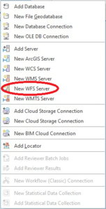
To begin the process of accessing LDS WFS, on the Insert tab, click the Connections drop-down list and click New WFS Server.
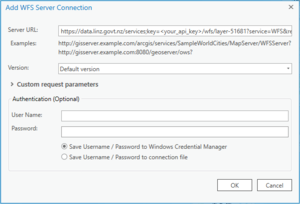
Paste the WFS URL for the LINZ Data Service in the following format:
This URL will provide you with a listing of all WFS-enabled datasets on the LINZ Data Service. You can also create connections to individual datasets. See the Services tab of any vector dataset, for the layer specific WFS URL. For example, the following WFS URL is for the NZ Place Names (NZGB) dataset:
It is recommended that users create connections to individual datasets rather than the list of all the WFS-enabled datasets, as ArcGIS Pro may struggle to process the larger datasets.
Important:
The default version for LDS Web Feature Services is WFS 2.0. You can choose an alternative WFS version to suit your version of ArcGIS from the Parameters option. For versioning help, see our guides to versioning and axis orders.
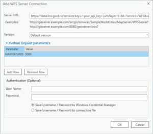
Then click Custom request parameters.
To test that the connection is working you can limit the size of the WFS response by entering a Max Features number:
Limiting the maximum number of features can avoid performance problems if the service includes a large quantity of features. The default value is 3000. If you want all records, make sure Max Features is blank.
Click OK on the open window. The WFS will be added under Services in the Catalog pane. The data can then be added to the current map or to a new map. The connection can be renamed to something other than the ArcGIS default: