
Landonline will accept a bearing-only or distance-only vector if the To mark exists in Landonline.
You need to calculate distance when the distant mark doesn’t exist in Landonline
If the distant mark doesn’t exist in Landonline, the vector needs to include a calculated distance.
If you calculate a distance, ensure:
- it represents the ellipsoidal distance
- you’ve accounted for line scale factors and projection corrections that need to be applied to a calculated grid distance.
For more information on Trig Observations in the Cadastral Survey Guidelines, see:
Cadastral Survey Guidelines – Trig observations
Dealing with distant trig observations in Plan generation
If a survey includes trig observations that are some distance away from the actual area of work, the spatial window in Plan Generation - Define Diagrams may take some time to load.
To minimise the impact of this, we recommend you follow the high-level steps outlined below:
- Do not capture trig shots initially. Remove these if already captured.
- Capture all other survey data as normal.
- Run Pre-validation to ensure that all Y rules (preventing submission) pass.
- Open Plan Generation - Define Diagrams and create all user-defined diagrams that will be required for the layout sheets.
For more information on creating user-defined diagrams, see:
Define diagrams - Return to capture and capture the trig observation(s).
For help with capturing a bearing only trig observation, see below:
Capture a bearing-only observation to a Trig or distant mark which exists in Landonline - Re-link 1 parcel.
- Re-run Pre-validation to ensure all Y rules (preventing submission) pass.
- Open Plan Generation - Layout Plan Sheets. Note: do not re-open Define Diagrams as the trig observations will now be included.
- In Survey sheets diagrams, remove the 'System generated traverse diagram' from the Survey sheet.
- Layout out the new 'user-defined survey traverse diagram'. The trig observations will appear as truncated lines.
- Layout all other diagrams.
If further user-defined diagrams are required after capturing the trig shots, you have two options:
- Repeat steps 1 to 11, or
- Leave the trig shots captured and wait for the spatial window in Define Diagrams to open. Warning: Depending on how long the trig shots are this may take some time.
Capture a bearing-only observation to a Trig or distant mark which exists in Landonline
To capture bearing-only observations to a distant trig, you’ll need to connect the vector to the existing node for the distant mark, and leave the distance field blank.
You may find it easier to locate and capture the existing mark first.
1. Locate and capture the existing distant mark
- Zoom out and move the spatial view to the general location of the distant mark.
Visit the Geodetic Database for help with locating geodetic marks:
LINZ Geodetic database Open the Layers panel from the right-hand Tools control bar.
Expand Marks using the chevron, then turn on the Underlying marks layer.
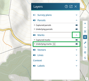


You may need to zoom in to the area further to see the underlying marks in the spatial screen.

Caution:
Turning on underlying marks too early can slow down the spatial view. To avoid this:
- Zoom in to the general location of the distant mark.
- Turn on underlying marks only once zoomed in, to help identify the specific underlying mark.
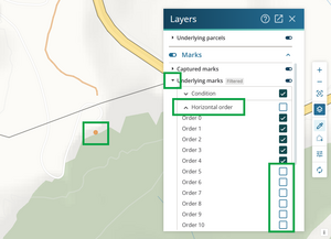
Use filters to help find the required mark:
- Select the arrow to the left of Underlying marks to filter the Underlying marks layer by Condition, Horizontal Order, or Vertical Order.
- Select the arrow on the left of each option to expand it and select your filters.
In this example, lower order marks are hidden to isolate the high order trig mark.
Select the existing mark for the Trig or distant mark using the Inspect and Adopt tool. A pop-up box appears with information about the selected mark.
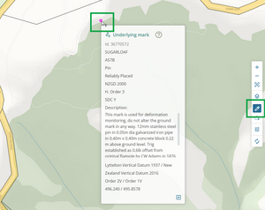
Select the Adopt this mark icon at bottom right of the pop-up box to add the mark to your survey.
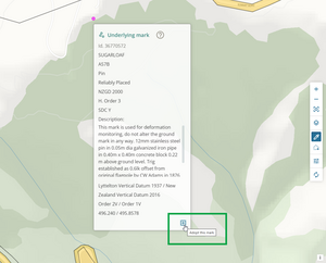
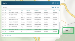
The mark is automatically linked when you adopt it. It appears on screen with a blue box surrounding it, and in the Marks panel at the bottom of the mark list.
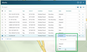
Edit the mark details in the Marks panel if necessary.
In this example the mark’s State is being changed from Adopted to Old.


2. Capture the observation to the distant mark
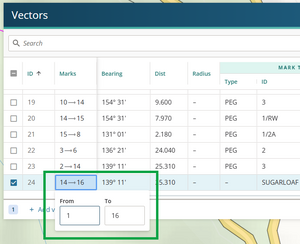
Open the Vectors panel and select Add vector at the bottom left of the panel.
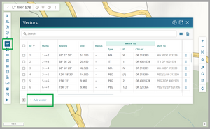
The new vector is added at the bottom of the list with pre-populated details:
- From is the To mark from the vector above
- To is usually the newly adopted mark
- The remaining fields copy the information from the vector above.
Edit the vector details to capture the observed bearing. Double-click in a field to edit it, then Tab to move to the next field.
Check and edit the From and To marks if needed.
Enter the observed Bearing.
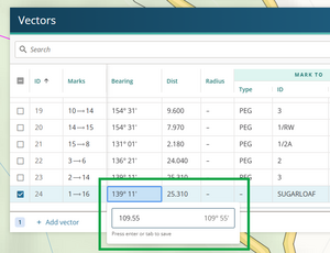
For a bearing-only observation:
- delete the value in the Dist field
- change the Dist Type to (None) - this appears as a dash
- change the Bearing type to Measured.


Capture a distance-only vector
To capture a distance-only vector:
- ensure both the From and To marks are linked
- leave the Bearing field blank
- change the Bearing type to (None) - this appears as a dash.
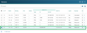
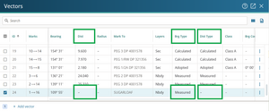
This example shows a distance-only vector.
