
Geodetic surveys were conducted throughout the region to determine the size and extent of movement following each substantial earthquake event. This information has now been fully analysed and mark coordinates recalculated using an updated New Zealand Geodetic Datum 2000 (NZGD2000) deformation model.
All Landonline spatial data, including geodetic data, has now been updated. Read about the South Island coordinate updates.
For users wishing to update their own data, information and authoritative post-earthquake coordinates are now available in the Geodetic Database.
Find information for surveyors about the 2016 Kaikoura earthquakes
February, March and April 2016 resurveys
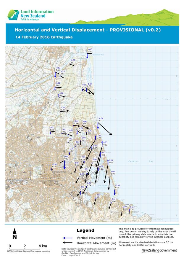
Our most recent geodetic survey in Canterbury was carried out after the magnitude 5.7 earthquake on Sunday 14 February 2016.
The results of these are shown below. The largest horizontal movement observed to date is 12cm. The largest vertical movement is 5cm.
The movements we have observed so far should not impact property boundaries. They do affect our network of survey marks, so we will do further surveys and update data for surveyors and others who use Canterbury coordinates.

Our next steps
Although the observed movements are relatively small, they are large enough to mean we’ll need to restore the geodetic control network. In the first half of 2016, we’ll do further geodetic survey work in eastern Christchurch and update the NZGD2000 deformation model. We’ll then update Landonline and the geodetic database with official post-earthquake NZGD2000 coordinates.
Provisional coordinates
Post-earthquake coordinates calculated from this survey are available on the LINZ Data Service (LDS).
As further geodetic surveys are completed, results will also be made available on the LINZ Data Service.
Surveying in affected areas
The Horizontal and Vertical Displacement plot can be used to assess the magnitude of ground movements in the survey area. The following options can be used to find NZGD2000 coordinates in affected areas.
Use existing geodetic database coordinates
For some surveys, the movements caused by the earthquake are small enough that the existing coordinates in the geodetic database (ie. those not updated for the earthquake) will be accurate enough. Cadastral surveys should be able to be completed using existing coordinates as it is the connections to control that are more important than the actual coordinates.
Use provisional post-earthquake coordinates
The survey could connect to marks included in the geodetic surveys that have already been completed. Post-earthquake coordinates for these marks can be downloaded from the LINZ Data Service.
Generate post-earthquake coordinates using PositioNZ-PP
The PositioNZ-PP service can be used to generate post-earthquake coordinates at a location convenient to the user. It is recommended that at least 4 hours of data is collected, which will usually produce coordinates that are precise to 2cm horizontally and 3cm vertically at a 95 percent confidence interval.
Shallow ground movement
There have been reports of isolated areas of liquefaction associated with the 14 February 2016 earthquake. In previous earthquakes, such as the one on 22 February 2011, this resulted in significant differences in ground movement over short distances.
The movement associated with the 14 February 2016 earthquake is primarily deep-seated tectonic plate movement. Any shallow ground movement resulting from this earthquake is expected to be small.