
Ground movements
On Monday 14 November 2016, the magnitude 7.8 Kaikoura Earthquake resulted in ground movements exceeding 5cm from the middle of the South Island to the bottom of the North Island.
Users and managers of spatial data need to consider what impact (if any) the earthquake has had on existing data. Another aspect to consider is the type of coordinates for new data collected in the affected area; should they be consistent with existing pre-earthquake coordinates or do they need to reflect post-earthquake positions? The answer to this depends on the accuracy of the spatial data and the particular application.
If the spatial data has lower accuracy than the size of the land movement in an area, then it usually does not matter whether the coordinates are updated to reflect the land movements. For example, if data is accurate to 0.5m in an area that has moved by 0.1m, then there is probably no need to update coordinates.
Where data is more accurate than the size of the land movement, then the application for which that data is used should be considered. For some applications, such as adding new features to an existing spatial layer, it may be important that new data is spatially consistent with existing pre-earthquake data in that layer. In other applications, such as engineering, it may be important that the new data reflects the post-earthquake changes.
The information provided on these pages about ground movements can help with that decision. There is also information about how to obtain post-earthquake coordinates.
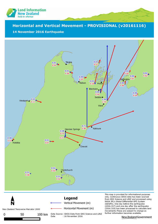
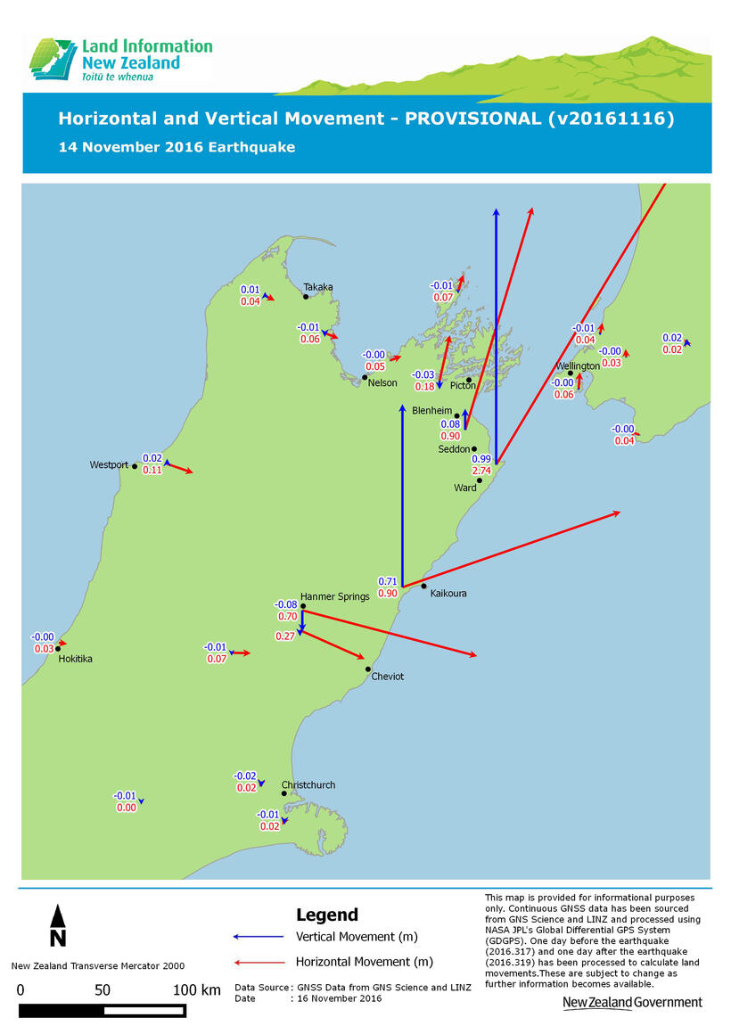
Additional maps showing more detail in some of the affected urban localities are available on our Land movement maps page.
Surveying in affected areas
The Horizontal and Vertical Displacement plot can be used to assess the magnitude of ground movements in the survey area. The following options can be used to calculate NZGD2000 coordinates in affected areas. Whichever option is chosen, it is important to keep careful records about how NZGD2000 coordinates were calculated.
Option 1: Use existing geodetic database pre-earthquake coordinates
For some surveys, the movements caused by the earthquake are small enough that the existing coordinates in the geodetic database (ie. those not updated for the earthquake) will be accurate enough. Cadastral surveys should be able to be completed using existing coordinates as it is the connections to control that are more important than the actual coordinates. This approach may also be appropriate where the movements are large, but are expected to be consistent over the area of the survey. Coordinates generated in this way should be noted as being in terms of pre-20161114 control.
Option 2: Generate post-earthquake coordinates using PositioNZ-PP
The PositioNZ-PP service can be used to generate post-earthquake coordinates at a location convenient to the user. It will provide NZGD2000 coordinates that reflect earthquake movement. It is recommended that at least 4 hours of data is collected, which will usually produce coordinates that are precise to 2cm horizontally and 3cm vertically at a 95 percent confidence interval.
See also:
- Guidance on using PositioNZ-PP to provide post-earthquake coordinates
- Information on referencing post-earthquake coordinates
Option 3: Connect to marks with post-earthquake coordinates published in the LINZ Data Service
The NZ Kaikoura Earthquake (14 Nov 2016) Geodetic Marks layer on the LINZ Data Service provides post-earthquake coordinates at geodetic marks. More coordinates will be added as further surveys are completed. Also see the information on referencing post-earthquake coordinates.
Reporting movement
For those working in the affected areas, please contact LINZ on customersupport@linz.govt.nz – with the subject line "Kaikoura Earthquake Movement" – if you find evidence of movement other than deep-seated or uniform block shift.