A datum is a reference framework that determines how points are referenced. This ensures that locations are consistently positioned, which allows spatial data to be exchanged between users. A datum needs to have a reference surface that heights and depths can be referenced against. This is a geoid, which is a shaped like a slightly squashed ball that gives a hypothetical global mean sea level surface, or a quasigeoid that provides a simplified version that is suitable for most applications. For New Zealand Vertical Datum 2016 (NZVD2016) the reference surface is New Zealand Quasigeoid 2016 (NZGeoid2016).
New Zealand Vertical Datum 2016 (NZVD2016)
NZGeoid2016 was calculated by enhancing a global gravity model (Eigen-6c4) with a combination of gravity observations and a digital elevation model. GNSS (Global Navigation Satellite System) and levelling survey observations were not used to compute NZGeoid2016.
Eigen-6c4 global gravity model
Find out more about gravity data collection and the computation of geoids and quasigeoids
NZGeoid2016 can be used to transform height data between NZVD2016 and NZGD2000 ellipsoidal heights, and can be used with our published relationship grids to transform heights to and from the 13 local vertical datums.
Read more about vertical datum coordinate transformations
Access the online coordinate converter
Note that NZGeoid2016 is not a datum, so heights should not be referenced to the geoid surface directly.
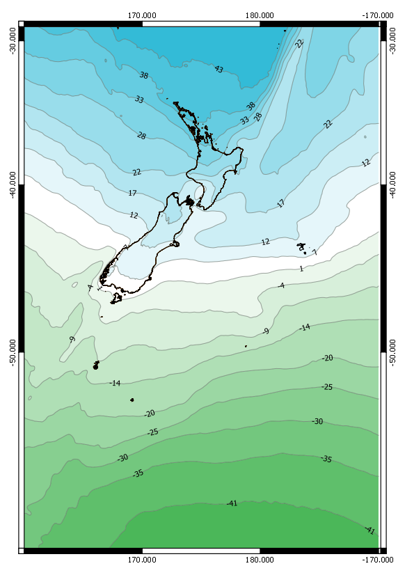
Parameters of Zealand Quasigeoid 2016 (NZGeoid2016)
- Coverage area: The coverage area is 160° E to 170° W, 25° S to 60° S. This corresponds to mainland New Zealand, its offshore islands, and the New Zealand continental shelf. This is the same area of coverage as New Zealand Geodetic Datum 2000 (NZGD2000).
- Resolution: The NZGeoid2016 model is gridded at a resolution of one arc-minute, which is approximately 1.8 kilometres.
- Expected accuracy: In urban areas, the expected accuracy of NZGeoid2016 is better than 3 centimetres. This accuracy is based on comparisons with geodetic control marks that have both GNSS and levelling survey observations.
The image below shows the NZGeod2016 model across its defined area, indicating the expected spatial variation of NZGeod2016.