
Overview
- The information you enter in the Survey details will form part of the survey you submit.
- When you create a survey, the firm, survey reference, survey purpose and land district will auto-populate into the Survey Details panel where these can be updated.
- Make sure you select the correct survey purpose when you create a new survey. Some survey purposes can be changed within the dataset itself but some, like Unit Plans, will limit you to changing the Survey Sheet option.
- If you change details such as the survey purpose, Land district, type of dataset, or vertical datum you should pre-validate the survey before submitting it. This ensures it is compliant and tells you if information needs to be added or edited.
What to do
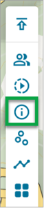
Select the Survey details icon from the left-hand workflow control bar.
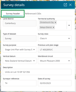
The Survey details panel appears displaying 2 tabs: Survey header and Referenced CSDs. The Survey header tab will be selected.
- Add new or edit existing information in the fields. Most of these fields use dropdown lists (click to open the dropdown, and then select the option).
- Land District will auto-populate from when the survey was created.
- Territorial authority – Select one or more territorial authorities from the dropdown list.
- Each selected authority will highlight and populate the field. (To remove a territorial authority, select the X icon to the right.)
- Type of dataset – For example, Survey or Parcels without Survey Information
- Survey purpose – this information will auto-populate from when the survey was created. Warning: Make sure you select the correct survey purpose when you create a new survey. Some survey purposes can be changed within the dataset itself but some, like Unit Plans, will limit you to changing the Survey Sheet option. See Survey purpose.
- Previous unit plan stage – This information will also auto-populate from when the survey was created. You need to enter the previous stage for some Survey Purposes. For example, enter the plan number in the Previous Unit Plan Stage field if this is a Staged Unit Development Plan that already has stages lodged. Don't include the unit plan suffix.
- Survey class – Select the relevant Survey Class.
- Vertical datum – In most cases you will select ‘none’, but if you have levels on any of the boundaries include the relevant Vertical datum that applies.
- Meridional circuit – Populate this field with the horizontal datum and circuit projection that the bearings of the survey are in terms of.
- Description – This is a free-text field for anything relevant to the survey or surveyor. See Cadastral Survey Rules 2021 for the items that must be included in the Dataset Description.
- Surveyor reference – This information will auto-populate from when the survey was created, and it is a free-text field that can be edited.
- Date of Survey – Click to bring up the calendar and select a date meaningful to the survey, such as when the field work was completed or when the surveyor created the dataset.
