In New Zealand, MGI is collected by various public and private organisations. The NZMGI-WG aims to increase the findability and accessibility of MGI.
National MGI Inventory
The NZ National MGI inventory was created to improve understanding of what data was collected in New Zealand waters and facilitate its discovery.
Initial work to create the NZ National MGI Inventory started through the Open Data programme with detailed stocktakes created by six organisations. Results of this work are available through catalogue.data.govt.nz
Those stocktakes were simplified, in order to consolidate them into one National MGI inventory and facilitate contribution from other organisations. Data has been grouped by categories and types, regions and organisations. Information on where to access or how to request data is also included.
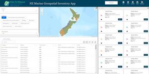
The National MGI Inventory is now discoverable and accessible via a web app:
NZ Marine Geospatial Inventory app

NZ marine data owners are encouraged to contribute to the National MGI Inventory by taking a short survey.
Support in undertaking a detailed Marine Geospatial Stocktake is available, though a guidance document published by the NZ MGI WG:
For more information email hydro@linz.govt.nz with the subject ‘MGI Inventory’.
Enabling Integrated Marine Management – an innovation project
In 2021 Toitū Te Whenua LINZ partnered with the following agencies to successfully secure funding through Department of Internal Affairs Digital Government Partnership Innovation fund:
- Office for Māori Crown Relations | Te Arawhiti
- Department of Conservation | Te Papa Atawhai
- Ministry for Primary Industries | Manatū Ahu Matua
This partnership explored how marine geospatial data can enable integrated marine management.
The Enabling Integrated Marine Management Project has two core components:
- A technology Proof-Of-Concept (POC) – test the value of a cloud-based Datamesh infrastructure in connecting existing data platforms, tools, and systems from various agencies.
Read the findings and recommendations from this POC - Te ao Māori perspective – engage with Kaitiaki o te Moana to facilitate access and reuse of MGI by Kaitiaki o te Moana. Outcomes of this component include:
- a hui in April 2023
- an online huitopa in June 2023
- a wananga report which summarises insights, key messages and recommendations (available upon request at hydro@linz.govt.nz)
- establishment of a kāhui kaumatua/advisory group to progress work items that support Māori in discovering, accessing and reusing MGI.
MGI Portals
The NZ MGI Data Portal study was undertaken to:
- support data users in finding, accessing and reusing NZ MGI
- encourage data custodians to share the MGI they hold
Te Kete Kōrero a Te Takutai Moana
- Purpose: assists applicants and decision makers in the context of the Marine and Coastal Area (Takutai Moana) Act 2011
- Functionality: discovery, viewing and access to MGI including permits/licenses to occupy marine space; marae; LINZ parcels; DDC data; and other MGI
AusSeaBed
- Purpose: allows to explore seafloor mapping products and access analytical assessment tools for the South West Pacific region
- Functionality: discovery, viewing and access to bathymetry, backscatter, side scan sonar data, etc
Petlab
- Purpose: acts as the collector for nationally significant geological collections
- Functionality: discovery and access to national geological material and geoanalytical data related to the physical samples
LAWA
- Purpose: makes environment data collected by regional and unitary councils, MfE and Cawthron Institute freely available to the public
- Functionality: discovery, viewing and access to environmental data (i.e. land, air and water related data)
Ira Moana
- Purpose: delivers a searchable database for genetic data from natural populations of wild organisms
- Functionality: discovery, viewing and access to genetic data and other information about biological samples
New Zealand Petroleum Basin Explorer
- Purpose: displays data published by GNS, NOAA, NZP&M, NIWA, LINZ, DOC, and other organisations
- Functionality: discovery, viewing and access to bathymetric, geophysical and sea level data
LINZ Data Service (LDS)
- Purpose: provides free online access to LINZ's most up-to-date land and seabed data
- Functionality: discovery, viewing and access to hydrographic and topographic data
IHO Data Centre for Digital Bathymetry
- Purpose: displays the locations of seafloor data collected through international campaigns.
- Functionality: discovery, viewing and access to bathymetric data
NZODN
- Purpose: access point for marine data published by NZ organisations (e.g. NIWA, Central government agencies, Cawthron Institute, councils, universities, etc.)
- Functionality: discovery, viewing and access to marine biological, geophysical, bathymetric and oceanographic data.