
An aerial shot of Te Motu Kairangi (Miramar Peninsula) with the future Watts Peninsula reserve area in the foreground.
Watts Peninsula is a culturally and historically significant area located near the entrance to Wellington Harbour. The land was occupied by Māori for pā, kāinga and mahinga kai, and throughout the past 160 years it has been used for coastal defence, farming and reformatory purposes.
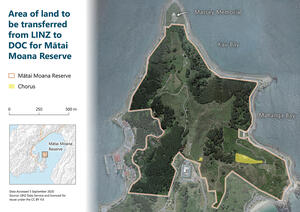
The 72ha reserve is being established at the northern tip of Te Motu Kairangi (Miramar Peninsula), preserving and regenerating the space for future generations to enjoy. It will be protected as a distinctive national destination with cultural, heritage and recreational benefits.
We are responsible for improving the area’s safety before it is transferred to the Department of Conservation (DOC) and designated as a reserve. Public access to the future reserve area is not formally authorised while our preparation work is underway.

Click to view an interactive map of Watts Peninsula
Establishing a reserve at Watts Peninsula
The land at Watts Peninsula is currently held under the Public Works Act 1981 for defence purposes, and we are working on behalf of the Crown to prepare the area for transfer to DOC so it can become a reserve.
With DOC and Te Arawhiti, we have been working in partnership with Taranaki Whānui ki Te Upoko o Te Ika (Taranaki Whānui) on the future governance of the reserve as Te Motu Kairangi sits within the rohe of local iwi Taranaki Whānui.
We’re continuing to make the area safe by reducing and removing hazards, and have completed several assessments which will help determine what type of reserve will be created.
Read the latest on our Watts Peninsula hazard reduction work
Timeline of key milestones
-
2000: The New Zealand Defence Force (NZDF) determines that their landholding on Te Motu Kairangi is no longer required for defence purposes.
-
2008: Several assessments are undertaken between 2008-2011 as part of the process undertaken when Crown agencies are considering the disposal of land. These assessments aim to ensure that wider national interests including historic heritage are identified before the land is disposed of, and whether these interests should be protected.
-
2011: Cabinet agrees that Watts Peninsula should be protected, preserved and developed as a distinctive national destination. The Ministry for Culture and Heritage begins planning to create a reserve which will reflect the area’s historical and cultural significance to the Wellington region.
-
2014: A Memorandum of Understanding is signed by the Minister for Arts, Culture and Heritage, the Port Nicholson Block Settlement Trust (representing Taranaki Whānui ki Te Upoko o Te Ika) and the Mayor of Wellington. The MoU sets out the relationship between the signatories, establishes the Watts Peninsula leadership and reference group, and sets out principles to guide the development of a vision for the future of the reserve.
-
2016: Cabinet agrees to transfer the land from NZDF to Toitū Te Whenua, and work begins on the process and resources required to declare Watts Peninsula a reserve under the Reserves Act 1977. Read the 2016 Cabinet Paper
-
2017: Ministers receive recommendations on remaining work required to address hazards on the Watts Peninsula site and declare the area a reserve. Read the 2017 Cabinet Paper
-
2019: Toitū Te Whenua receives funding over four years for property management and to undertake hazard reduction work to make the area safe for public access.
-
2020: Site hazard assessments are undertaken which help prioritise the work required to enhance safety at the site and enable public access.
-
An Iwi Crown Working Party was established comprising of Taranaki Whānui, Toitū Te Whenua, the Department of Conservation and Te Arawhiti, with the aims of working in partnership with iwi on the future of Watts Peninsula. Crown working group members commit to ensuring recognition of Māori interests in the land.
-
2021: Hazard reduction work continues, including significant procurement for site safety works and maintenance while the reserve is being developed.
-
This includes procurement of a specialist arborist contractor to remove dangerous logs and clear dangerous trees.
-
Toitū Te Whenua continues work with Taranaki Whānui on iwi aspirations for the site.
-
2022: A Heritage Values Assessment was completed to ensure the cultural, archaeological, historical, architectural, technological, and aesthetic values of the site are adequately considered.
-
The Heritage Values Assessment, coupled with a Detailed Seismic Assessment also completed in 2022 provides recommendations for long-term management to maintain the heritage structures on the site.
Work planned for 2023
-
Undertaking asbestos removal, track access and stormwater improvement work on Mag Road.
-
Management of other remaining hazards across the site.
-
The Crown and iwi will continue work to confirm future governance arrangements for the reserve.
Preparing the site for the public
We are responsible for improving the area’s safety before it is transferred to DOC and formally designated as a reserve. This work has included removing dangerous pines at the beginning of 2022.
In 2023, we’ll remove asbestos-containing materials and upgrade stormwater drainage on the track from Shelly Bay to the old film set/Women’s Reformatory area.
Public access to the future reserve area is not formally authorised while our preparation work is underway.
Read the latest on our Watts Peninsula hazard reduction work
Disposal of surplus land at Mount Crawford
The future reserve is next to land at the former Wellington Prison at Mount Crawford which is proposed for transfer to the Ministry of Housing and Urban Development as part of its Land for Housing programme. This land is made up of Department of Corrections land at Mount Crawford and a neighbouring 3.3ha area of former New Zealand Defence Force land.
We have a statutory role in administering the land transfer under the Public Works Act 1981. However we will not have any future role with the site once the proposed transfer takes place or involvement in determining how the land will be used in the future.

The red area in this map is Department of Corrections land with the green area being New Zealand Defence Force land.
Read more about the Crown Property disposal process