Many organisations are working to help New Zealand school students, teachers and careers advisors understand more about the spatial sciences and the exciting career opportunities available:
Geospatial virtual field trips for schools
Toitū Te Whenua Land Information New Zealand (LINZ) sponsors an annual geospatial Virtual Field Trip for schools through the well established LEARNZ programme run by CORE Education. The aim is to raise awareness among school students and teachers of the value of the spatial sciences and related exciting career opportunities. Multi-media curriculum resources from the past geospatial Virtual Field Trips are freely available under Creative Commons licences at the links below:
- 2012: Geospatial – how location based information is helping the rebuild of Christchurch
- 2013: Geospatial – the use of skills, tools and data by people in Canterbury
- 2014: Geospatial – the use of skills, tools and data by people in Canterbury
- 2015: High Country hi-tech – using drones, mobile maps and other smart tools in remote New Zealand
- 2016: Geospatial - Where are we? – navigating and positioning on sea, land and air
- 2017: Map my waahi – My place, my story
- 2017: Finding Resilience – the technology behind locating and responding to natural hazards
- 2018: Land, Sky and Space – accurate satellite positioning takes off!
- 2019: Matariki and Navigation: Kupe, Cook and Today
- 2020: Map my Waahi Climate Change
- 2020: Get outdoors safely – with maps!
- 2022: Hokonui restoration: Tech in te taiao
- 2023: Our place names: Ngāti Maniapoto stories
- 2024: What lies beneath. Discovering the secrets of our seabed
Some comments from school teachers about previous geospatial virtual field trips:
- “The importance of maps and surveying to the rebuild of CHCH. How the whole of CHCH area was affected, not just the city, New vocabulary words. That science is very important”
- “It will address the key components of the GIS standard in Yr11 Geo”
- “Mapping skills were hugely improved. Knowledge and understanding of the situation in Christchurch became real to these Auckland students”
- “The background notes are superb. The material can be revisited and is great for revision / extension because it's just soooo damn good”
The LINZ 2014 geospatial virtual field trip for schools was the winner of the People and Community category in the 2014 New Zealand Spatial Excellence Awards.
The 2019 LINZ Geospatial VFT was the most popular in the 23+ years of the LEARNZ Programme history with 10,003 students enrolled from 347 classes.
https://vimeo.com/170939542
Continuously Operating Reference Stations for GPS from LEARNZ on Vimeo.
Subject Matter Experts from the LINZ Geospatial Virtual Field Trips say in writing and/or video what their work involves and why they love their jobs:
- Helen Payn – GIS Intern at Land Information New Zealand (2018 VFT)
- Duane Wilkins – Geographic Information Advocate at Land Information New Zealand (2017 VFT)
- Sharyn Westlake – Senior Engineer, Flood Protection at Greater Wellington Regional Council (2017 VFT)
- Jennifer Coppola – Nautical Cartographer at Land Information New Zealand (2016 VFT)
- Dionne Hansen – Senior Geodetic/Geophysical Analyst at Land Information New Zealand (2016 VFT)
- Paula Gentle – Geodetic Surveyor at Land Information New Zealand (2015 VFT)
- Marcus Girvan – Biosecurity Project manager at Boffa Miskell (2015 VFT)
- Andrew Ferrel – National Imagery Manager at Land Information New Zealand (2014 VFT)
- Jeremy Severinsen – Portfolio Manager at Land Information New Zealand (2014 VFT)
- Richard Freeman – Cartographer at Land Information New Zealand (2013 VFT)
- Jennifer Ryan – Manager Chart Production at Land Information New Zealand (2013 VFT)
- Jeremy Gulson – Senior Spatial Consultant for SCIRT (Stronger Christchurch Infrastructure Rebuild Team) (2012 VFT)
- Nic Donnelly – Geodetic Surveyor at Land Information New Zealand (2012 VFT)
GIS in schools programme
Since March 2017, New Zealand schools can have free access to Esri’s ArcGIS Online software that lets students and teachers explore and analyse data using maps. To learn more and to request a free account, schools should access http://www.eagle.co.nz/gis-schools
Free lesson plans are also developed by Eagle Technology (the NZ Esri software distributor) in conjunction with New Zealand teachers and relate to NCEA Geography Achievement Standards at Levels 1,2 & 3 that specifically reference use of GIS.
Leaving School magazines
Toitū Te Whenua LINZ has worked with the Geospatial Capability Committee (GCC) to publish a profile of a GIS graduate in an edition of the Leaving School magazine each year. Fifty-five thousand copies of each Leaving School magazine edition are distributed free to senior students in every secondary school in the country. The stories of the GIS graduates help senior school students, teacher and careers advisors become more aware of exciting career opportunities in New Zealand’s geospatial industry and explore related tertiary study options.
The profiles in the Leaving School magazine are also part of the GCC’s and Toitū Te Whenua’s ecosystem approach to helping develop people’s geospatial awareness and skills across the school, tertiary and industry sectors. This supports in particular the Toitū Te Whenua outcome that geographic and property information are used effectively to deliver value for New Zealand. People with the right awareness, knowledge and skills are needed for this to happen!
Check out the profiles in the online versions of the Leaving School magazine and pass the links on to any school students, teachers or careers advisors you think may be interested.
- Kate Waterhouse (GIS Analyst at the Bay of Plenty Regional Council) profile on p.6 of the online version of the Leaving School magazine (issue 13 July 2018)
- Sam Keast (Senior GIS Analyst at the Ministry of Social Development) profile on p.9 of the online version of the Leaving School magazine (issue 16 August 2019)
- Kasey Ooman (Resilience Advisor at Land Information New Zealand) profile on p.26 of the online version of the Leaving School magazine (issue 19 October 2020)
- Andrew Douglas-Clifford (Cartographer & Geospatial Analyst at Tonkin + Taylor) profile on p.38 of the online version of the Leaving School magazine (issue 22 October 2021)
- Sean Bragg (Geospatial Analyst at Ngāi Tahu Holdings Ltd) profile on p.10 of the online version of the Leaving School magazine (issue 25 October 2022)
- Grace Kuru (Graduate GIS Analyst at Abley) profile on p.6 of the online version of the Leaving School magazine (issue 28 October 2023)
- Kate Downes (Hydrographic Surveyor at DML) profile on p.11 of the online version of the Leaving School magazine (issue 29 May 2024)
- Brad Cooper (Hydrographic Surveyor at Toitū Te Whenua Land Information New Zealand) profile on p.6 of the online version of the Leaving School magazine (issue 30 July 2024)
- Anataia van Leeuwen (Environmental Consultant at Tonkin + Taylor) profile on p.5 of the online version of the Leaving School magazine (issue 31 October 2024)
- Carolina Faka’osi Manu (Geospatial Specialist at Toitū Te Whenua Land Information New Zealand) profile on p.7 of the online version of the Leaving School magazine (issue 32 May 2025)
- Kimberley D’Arcy (GIS Analyst at Wellington City Council) profile on p.6 of the online version of the Leaving School magazine (issue 33 July 2025)
Information for School Leavers – Survey and Spatial New Zealand Tātai Whenua
"Spatial and surveying careers open up opportunities to work in exciting and unique areas. You could end up using the latest technology from drones, digital mapping, smart sensors, 3D printing to artificial intelligence. People in the industry design, build, manage and protect everything you see in the world." (RICS.org)
Check out information about Spatial and Surveying careers.
Careers New Zealand – geospatial specialist

Geospatial specialists work in a wide variety of areas as the following graphic shows. People specialising in other disciplines and domain areas are also finding that increasingly some geospatial foundation skills are very useful for their work.
Find out more at Careers New Zealand about the geospatial specialist occupation, including what the job is, job entry requirements and job opportunities.
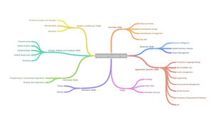
Image description
Career pathways related to geospatial foundation skills:
- Geodata skills
- Data processing
- GeoDatabase design
- GeoDatabase management
- Big data
- Business skills
- Business intelligence
- Spatial business analysis
- Project management
- Application specific skills
- Production mapping/charting
- 3D (CAD/BIM, etc)
- Asset management
- Engineering
- Environmental management
- Social services
- Emergency response/civil defence
- Etc
- Policy
- Strategy
- Open data
- Information security
- Research skills
- Tertiary
- Industry
- Developer skills
- Programming of GIS desktop applications
- Building web applications
- Design, editing and analysis skills
- Geoprocessing
- Spatial analysis
- Designing maps
- Editing spatial data
- Modelling
- System architecture skills
- Architecture design and strategies
- Interoperability
- Standards
Geospatial specialists work in a wide variety of areas as the above graphic shows. People specialising in other disciplines and domain areas are also finding that increasingly some geospatial foundation skills are very useful for their work.
Inspiring the Future Aotearoa
The Inspiring the Future Aotearoa initiative is organised by the Tertiary Education Commission. At an Inspiring the Future event, primary and intermediate school students (7-13 years age group) hear from volunteer role models in their communities, learn about different jobs and why people love doing them, as well as their pathway and challenges they faced along the way. If you are interested in showcasing your job in the geospatial industry to school students then you can find out more about the Inspiring the Future initiative and sign up as a role model.
GIS Day
Each year, GIS Day provides an international forum for users of geographic information systems (GIS) technology to demonstrate real-world applications that are making a difference in our society.
Children’s map competition
Every two years the New Zealand Cartographic Society coordinates a national children’s map competition with winners going forward to the children’s map competition.
New Zealand has been pushing above its weight at recent International competitions having winners at that level with:
- 2011: Tauranga Boys College (Hayden Livingston)
- 2015: Te Kauwhata College (Amy Wang)
- 2017: Tauranga Girls’ College (Rebecca Kneale & Akira McTavish-Huriwai) and Bishop Viard College (Phoebe McClean)
- 2019: Matakana School (Barnaby Blampied)
- 2021: Mahurangi College (Barnaby Blampied)
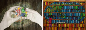
The World at my Fingertips – "Remains a Puzzle” by Hayden Livingston and “World Section” by Amy Wang

“Through a Child’s Eyes” by Rebecca Kneale & Akira McTavish-Huriwai.

“Trump’s World” by Phoebe McLean
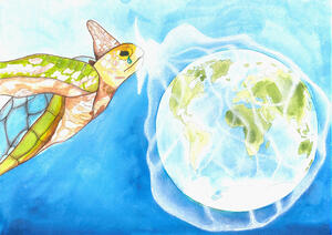
“A Turtle’s Tear: Our Plastic Oceans” by Barnaby Blampied
Check out all the amazing winners of the 2021, 2019, 2017 and 2015 NZ Children’s Map Competitions.
Check out the National Geographic article about the 2017 International Children’s Map Competition (with 2 New Zealand maps among the 14 winners from 34 countries!)
Grow GIS NZ Facebook page
There are plenty of interesting posts on the Grow GIS NZ FB page around geospatial capability related events, courses, people and places.
New Zealand Geographic Archive
Did you know that all schools have free access to the massive New Zealand Geographic Archive?
Every school has unlimited access to every issue of the award-winning New Zealand Geographic ever published - 2000 stories and 10,000 images of New Zealand’s environment and society - fantastic local material to support literacy, science, history, geography, natural world studies and more. It’s free for students and teachers alike, just visit NZGeo stories from within your school.
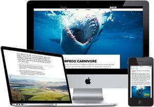
Use the search field on the home page to find material you’re interested in, or go directly to your subject interest area, such as geography or science & environment. Have a look at departments like Geo news for the latest science, geography and environment news, or for the coolest, most intriguing, useful scientific mechanisms of the natural world, try life. New to the service are Special Focus areas, gathering all the stories, photos, video and audio around a single subject - see Kermadecs or predator free.
To make the most of the free subscription, sign up to the free email service for teachers and schools - register for NZGeo Connect. This weekly email contains the latest trending subjects and background reading to the news headlines.
Further information
Any queries about Geospatial for Schools email growgisnz@linz.govt.nz