
Overview
- You don’t have to import a LandXML file to capture a dataset. Instead, you can create the survey manually by entering vectors as well as new and existing marks into their respective tables, and linking marks to existing nodes.
- Some datasets, such as those with the survey purpose Flat Plan, will not require any marks or vectors to be captured. This may mean it is simpler to manually capture the information instead of importing a LandXML file.
What to do
Once the dataset has been created, open the Survey details panel, and complete the relevant details including Meridional Circuit.
The next thing to do is shift the spatial view to the location of the land subject to the survey.
There are multiple ways to do this, we’ll show you the three most common ways:
- Pan and zoom in the spatial view to locate the subject land
- Add an existing parcel
- Add an existing mark using node id
Pan and zoom in the spatial view
- You can pan (scroll) around spatial view by clicking, or holding a finger, on spatial view and moving it around to focus on the desired area. Use the mouse wheel, or two finger expansion if using a tablet or touch screen, to zoom in and out in the spatial view. Alternatively, use the zoom functions from the spatial tools control bar.
Use these functions to pan and zoom to the area of interest for your survey.
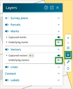
- Once you’ve located the land subject to survey, you can display the existing marks and vectors by opening the Layers panel from the spatial tools control bar.
- Next, adopt existing marks and adopt existing vectors to begin populating your survey data.
- Then capture the land under survey as an existing parcel or existing parcels by adding the parcel from the spatial view.
- Continue data capture by adding new vectors, adding new marks and adding new parcels as appropriate.

Add an existing parcel
You will probably know at least one appellation for the land subject to survey.
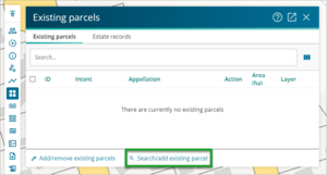
- Open the Existing parcel panel and select Search/add existing parcel.

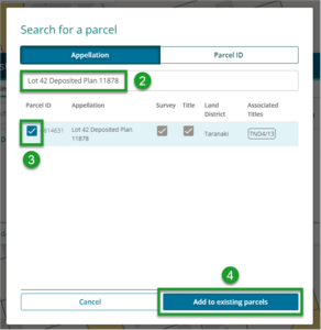
- Enter the parcel appellation in the Search field.
- Select the desired plan from the list by ticking the checkbox.
- Select Add to existing parcels.
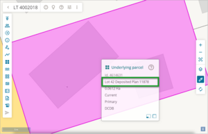
- Select the Zoom to survey icon on the Spatial tools control bar

- The spatial view should now be centred on that existing parcel.
- Once you’ve located the land subject to survey, you can display the existing marks and vectors by opening the Layers panel from the spatial tools control bar.
- Next, adopt existing marks and adopt existing vectors to begin populating your survey data.
- Continue data capture by adding new vectors, adding new marks and adding new parcels as appropriate.


Add an existing mark using node id
If you know a survey mark that you want to include in your survey, and you know the corresponding node id, you can search and add that mark as a starting point.
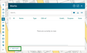
- Open the Marks panel.
- Select Add mark.
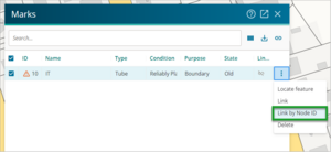
- Once the new mark has been added to the Marks panel, select the three dot icon at the end of the row and select Link by Node ID.
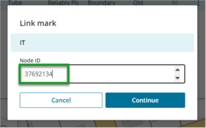
- Enter the Node ID into the appropriate field and select Continue.
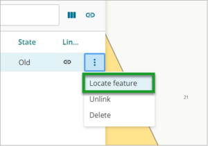
- Select the three dot icon at the end of the row and select Locate feature.
The spatial view will refresh and be centred on the existing mark that has just been linked.
- Complete the necessary details for the marks as appropriate.
- Continue to capture by adding new vectors, adding new marks and adding new parcels as appropriate.


