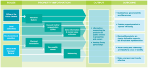
The Property Information system includes information on:
- property boundaries
- zoning, which shows how land and property can be used
- rating valuation, which enables the funding of local government services such as sewerage, rubbish collection, water provision (at the property level) and recreational, arts, environmental and community services (at the community level)
- market values, which enable mortgages to be raised and lodged on titles, and assist with the sale and transfer of property assets
- sales history, which shows the history of a property’s value
- property addresses, which are needed for mail and courier services, emergency services like fire, police, and ambulance, as well as utilities like power and water
- utility and infrastructure connections, which owners, tenants, providers, developers, councils and others in their planning for the future
- electoral boundaries, which assist the efficient and transparent election of local representatives
- geographic place names, which help us find where we are and where we want to be on land or undersea, and are particularly important for emergency services and maritime safety. Place names are also important landmarks of the history, culture and identity of our nation and the communities within it.
- other information produced as part of the resource management or building system, such as:
- resource and building consents, which shows the approved development of the property over time
- building information from buyers or sellers, emergency services and finance or insurance companies about the performance of the building.
Parts of the system are governed by the following pieces of legislation:
- property values for market and local government rating purposes through the Rating Valuation Act 1998 and Valuers Act 1948
- electoral boundaries through the Electoral Act 1993
- geographic place names through the NZ Geographic Board (Ngā Pou Taunaha o Aotearoa) Act 2008
- addresses through the Local Government Act 2002 and Electoral 1993.
Who is involved in the Property Information system?
The Valuer-General provides technical advice to the government on valuation issues, setting standards for the District Valuation Roll (DVR), and ensuring those standards are met. They also set rules for rating valuations, and auditing the work carried out or commissioned by local authorities in complying with these rules.
Local authorities use the DVR to help set rates that fund essential local services. They also provide public property and rates information that assists the property market to function efficiently.
The Surveyor-General provides advice on geographic place names, addressing and electoral matters. They are a member of the Cadastral Surveyors Licensing Board and chair the New Zealand Geographic Board.
We support the Valuer-General and the Surveyor-General to carry out their statutory roles, including assistance with analysis to inform their statutory decisions and administrative support.
We work with a range of experts and providers who provide information to inform well-informed property decisions that also support the system to run effectively. They include surveyors and valuers, private businesses who provide property information and analysis.
