Permanent structure boundary usage
A permanent structure boundary is a boundary related to a building or recognisable physical structure that is likely to remain undisturbed for 50 years or more. A permanent structure boundary also includes the outline of a future development unit (CSR 2021 Schedule 2 Dictionary).
A permanent structure boundary may be used for a unit or lease parcel and rights associated with them, as specified in rule 56(1)(a) to (c).
The use of a permanent structure boundary for an easement or covenant is permitted only where the use of the right is related to the structure (r 56(1)(d)).
Examples include a right of way over a footbridge between two commercial properties. When the footbridge (permanent structure) is removed, the easement becomes redundant. In this case, the permanent structure may define the horizontal extent and/or the vertical extent of the right of way.
A permanent structure boundary is not permitted to define a primary parcel boundary.
Accuracies of permanent structure boundaries
There are two accuracy standards for permanent structure boundaries:
- Accuracies between the points on a permanent structure boundary and any other boundary (r 57(1)). These are the same accuracies as used for right-line boundary points on primary parcels.
- Accuracies between all points on the permanent structure boundary and all points on the permanent structure (r 57(2)). These are the same accuracies that apply to boundary referencing of primary parcels.
The accuracy between points on a permanent structure boundary and any other boundary must not exceed the boundary tolerances specified in rule 27 (rule 57(1)).
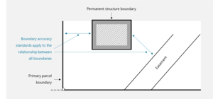
Figure 1: Accuracy requirements between boundary points of permanent structure boundary and any other boundary.
The relationship between all points on a permanent structure boundary and the permanent structure must not exceed the referencing tolerances in rule 21 (rule 57(2)).
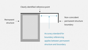
Figure 2: Accuracy standard between permanent structure and permanent structure boundary.
Accuracy of underlying primary parcel
Where a new permanent structure boundary is being defined on a unit or cross lease development and the definition of the base land is insufficient for the determination of its compliance with the accuracy standards in rule 27 the base land must be first redefined as a new primary parcel. This ensures the accuracy standards between the permanent structure boundary and underlying primary parcel can be met.
Existing unit and lease boundaries may be accepted
The boundaries of an existing unit or lease parcel may be accepted in the subsequent stage of a unit or cross lease development where:
- that parcel was included in an approved CSD (r 58(2)(a))
- no changes are being made to the parcel boundaries (r 58(2)(b))
- no changes are being made to the record of title (r 58(2)(c))
This enables existing unit or lease boundaries to be depicted in exactly the same manner as they were depicted on the original CSD (r 75). The existing parcel appellation must also be retained (r 58(3)).
Where the boundary of a new unit or lease parcel is in common with an unchanged parcel it may be accepted (r 58(4)). This does not apply to a future development unit.
Using an existing restrictive covenant boundary for a new restrictive covenant parcel
Rule 58(4) does not apply to an existing restrictive covenant boundary on a cross lease development. Lease parcels (that is, flats) are defined by the building they relate to, even where a former flats plan did not include a description of the boundary. In the past, restrictive covenant boundaries did not necessarily follow a structure and were often not described on a flats plan, leaving their location uncertain.
In the case of a subsequent stage of a cross lease development or where part of an existing cross lease development is being changed, the following may be applied:
- A boundary of a new restrictive covenant parcel may be an adopted boundary where it is in common with an abutting existing restrictive covenant parcel and the boundary complies with the current Rules for permanent structure boundaries (PSBs). In this case, the new CSD must reference the source CSD. This is illustrated by the wooden fence in the example in Figure 3 below. The permanent structure that the adopted boundary relates to must still exist.
- Where the existing boundary does not comply with the current Rules for PSBs, the boundary may be re-established in the same position. The re-established boundary must comply with the Rules for PSBs. The survey report must confirm that the spatial location and extent of the boundary has not changed and outline the decisions made and information used to define the boundary (r 72(i)). This is illustrated by the offset dimensions shown in blue in Figure 3 below.
- Where the boundary is not re-established in the same position, the boundary becomes a new boundary that must be defined by survey (r 13(b)). Where it is not obvious that the boundary is either a new or a re-established boundary, the survey report must clarify the situation (r 72(i)).
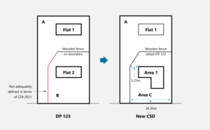
Figure 3: Use of existing restrictive covenant boundaries.
Height-limited boundary points on existing unit developments
Where reduced levels are used to define new boundaries in an existing unit title development, they must be in terms of the datum used for the previously deposited CSD (r 62(1)).
A reduced level must not be used where the boundary is a permanent structure boundary since this would be ambiguous as to what defined the boundary (r 107(a)). Note, a CSD may include both permanent structure boundaries and height-limited boundaries, but they must be for different boundaries.
Refer to:
Depicting permanent structure boundaries on the title diagram
The following scenarios illustrate the many different options for depicting permanent structure boundaries on the title diagram.
Depicting permanent structure boundaries where permanent structure boundary is coincident with structure
Where a permanent structure boundary is coincident with a physical structure, the title diagram must depict the relationship between the boundary and the structure clearly and unambiguously (r 101, r 107(a)). The title diagram must also describe the permanent structure (r 101(c)).
This relationship can be depicted or it can be annotated. The annotation can be applied to individual boundaries or it could be a generic note, provided that the relationship is clear in every instance of the boundary.
Where the boundary and the relationship to the structure are the same for each unit, the relationship to the physical structure does not have to be depicted around the full extent of every unit. Generic diagrams may be used, and may be distorted to provide clarity, provided they are referred to on a main diagram.
Two examples are shown here:
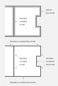
Figure 4: Where horizontal boundary coincides with the structure.
Depicting permanent structures and their boundaries where they coincide with underlying parcel boundaries
Where a non-primary parcel boundary is intended to be coincident with an underlying primary parcel boundary it must be the same form as that underlying primary parcel boundary (r 46(3)).
Where the permanent structure boundary coincides with the underlying primary parcel boundary, the relationship of the physical structure to the boundary must be clearly depicted, particularly where the structure extends beyond the boundary (r 101, r 107).
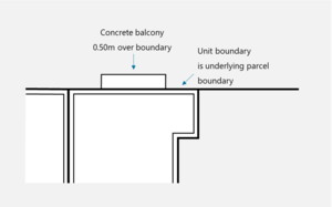
Figure 5: Bird's-eye view where the permanent structure boundary coincides with underlying boundary.
Depicting permanent structure boundaries where permanent structure boundary is not coincident with structure
A permanent structure boundary that extends beyond the physical structure to intersect with another boundary must be clearly defined on the title diagram (r 101(b), r 107). The title diagram must also enable any point on the permanent structure boundary to be accurately ascertained in relation to the permanent structure (r 101(e)).
Two examples are shown here:
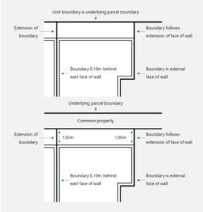
Figure 6: Bird's-eye view where the unit boundary extends beyond the physical structure.
In some cases, a unit boundary will be located in space above (or below) the physical structure. Such boundaries can be defined by dimensions (usually vertical distances) from clearly defined points on the structure (r 101(b), r 107).
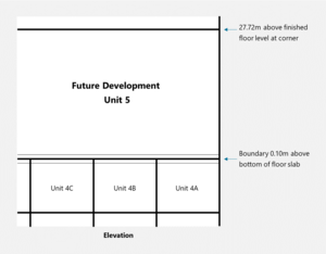
Figure 7: Elevation where unit boundary is in space above structure.
Depicting the relationship of units and cross lease areas to estate boundaries in the CSD diagrams
Where there is more than one underlying primary parcel within an estate record (see Figure 8 below), the spatial depiction of unit boundaries with any underlying primary boundaries internal to the estate boundary is not required (r 47, r 98(1)(a)). This means that the 'internal' primary boundary is not required to be depicted.
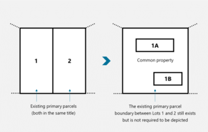
Figure 8: A unit or cross lease development over two underlying parcels.
Depicting the relationship of unit and cross lease boundaries where they are close to other parcel boundaries
The depiction of the spatial relationship between each unit or cross lease area and every other non-primary parcel in the CSD must be sufficient to ensure an unambiguous spatial relationship between the parcels within the development (r 98(1)(b), r 107(a)).
Where the parcels are in close proximity it may be necessary to show a distance between them to ensure the relationship is clear (see Figure 9 below). Where the permanent structure boundary is within 1 metre of the underlying parcel boundary the title diagram must accurately define the relationship (r 101(d)). The depicted relationship must comply with the accuracy standard in rule 57(1).
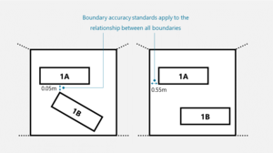
Figure 9: Where unit or lease boundaries are close.