
Overview
For tidal boundaries refer to:
Tidal boundaries
Water boundaries can be complex for a number of reasons:
- they are ambulatory, that is, their position can change over time
- there are common law aspects including the doctrine of accretion and erosion
- there are legislative requirements to meet in terms of the Marine and Coastal Area (Takutai Moana) Act 2011, Resource Management Act 1991, Conservation Act 1987, Te Awa Tupua (Whanganui River Claims Settlement) Act 2017 and others including Treaty settlement legislation
- there have been different practices applied across different land districts and different requirements in different versions of the cadastral survey rules over the years.
When a Cadastral Survey Dataset (CSD) is prepared containing a water boundary, that boundary will be required to be either:
- accepted
- adopted
- defined by survey
or in a minority of cases made an irregular boundary or right-lined.
Because of these factors, each water boundary included in a CSD needs to be carefully considered and a decision made about how to deal with it. All relevant decisions must be fully documented in the survey report.
What is a water boundary?
It is specified that a water boundary must follow the landward margin of:
- a river bed or a stream bed
- a lake bed
- a tidal area.
Additional guidance about boundaries that follow tidal margins is provided in Tidal boundaries.
Note that the term ‘natural boundary’ has been used in the past for boundaries following water margins and other physical features. However, for clarity the term ‘natural boundary’ should now be avoided when referring to a water boundary.
What is not a water boundary?
The following types of boundaries are sometimes confused with water boundaries, but are not water boundaries:
- a water centre-line boundary (r 11(1))
- an irregular boundary (r 9.1)
- a height-limited boundary which is the surface of a water body or the bed of a water body (r 12(2)(b)).
Key concepts
There are complex common law principles, modified by statute, that apply when boundaries of land are defined by the edge of the sea, lakes, rivers, or streams.
A water margin may physically move on the land, but the corresponding water boundary may or may not move ‘at law’ depending on:
- how the water margin has moved
- the application of relevant common law principles
- any statutory requirements
- the ownership of the bed.
Two of the key common law principles are:
- the doctrine of accretion and erosion (which can also be described as the doctrine of gradual and imperceptible addition to or eating away of land)
- usque ad medium filum aquae (to the centre-line of the river) presumption - that is, the presumption that landowners have rights to the centre-line of non-tidal and non-navigable rivers. These rights are commonly referred to as AMF rights.
Some relevant statutes include the:
- Canterbury Property Boundaries and Related Matters Act 2016 which deems boundaries, including water boundaries, to have moved with the movement of land caused by the Canterbury earthquakes.
Re-establishing Canterbury earthquake affected boundaries in greater Christchurch - Conservation Act 1987 which in certain circumstances requires the beds of qualifying water bodies to be surveyed out of the land and marginal strips to be created along water bodies upon the disposal of Crown land.
Recording movable marginal strip and esplanade strip parcels - Crown Grants Act 1908 which defines the seaward boundary of land granted.
Section 35 of the Crown Grants Act 1908 - Land Transfer Act which authorises the Registrar-General of Land to make alterations to record a boundary change resulting from accretion or erosion and allows a landowner to apply for a Record of Title for land that was formerly a river or stream bed
- Marine and Coastal Area (Takutai Moana) Act 2011 (MACAA) which requires some land below MHWS to be shown as common marine and coastal area and provides for the issue of title for some types of reclaimed land.
Tidal boundaries - Resource Management Act 1991 (RMA) which provides for the issue of title to some types of reclaimed land, requires the creation of esplanade strips and reserves, common marine and coastal area to be depicted and bed of lake or river to vest in some circumstances.
Recording movable marginal strip and esplanade strip parcels
Land becoming common marine and coastal area under s 237A RMA upon subdivision
Recording water bed to vest under sections 237A or 239(1)(c) RMA 1991 - Manukau Harbour Control Act 1911 which vested most of the land below Mean High Water Springs in the Manukau Harbour in the Harbour Board.
Tidal boundaries (accounting for the whole of the parcel) - Te Awa Tupua (Whanganui River Claims Settlement) Act 2017 which affects land containing and adjoining water bodies in the Whanganui River catchment.
Treaty settlement legislation may also be relevant.
Some of the key terms and abbreviations that need to be understood relating to water boundaries are:
Accretion
Accretion occurs where water recedes gradually and imperceptibly from the land, or where water gradually and imperceptibly deposits sand, shingle and silt. The doctrine of accretion provides that where accretion occurs along a water boundary, the new land belongs to the owner of the parcel of land to which it is added (or from which the water has receded).
Artificial Diversion
where the position or extent of a water body has permanently changed due to direct human alteration of the bed or banks (including reclamation or the placement of natural or artificial structures). While this results in a change to the physical margin of the water body it does not result in a change to the legal boundary.
Avulsion
where the change in the physical boundary between land and water was not gradual and imperceptible but either sudden or perceptible as it was occurring. For example, a stream suddenly breaking through its banks and forming another channel, or waves rapidly washing away coastal land during a storm.
Erosion
Erosion occurs where water gradually and imperceptibly encroaches on the land or washes away land. Where erosion occurs along a water boundary the owner of the parcel of land which is being eroded loses that part of their land.
MHWM
mean high water mark
MHWS
mean high water springs
Reclamation
the deliberate filling of land that was below the line of MHWS or part of the bed of a lake or river, so as to make it permanent dry land.
Further details of applying the rules in scenarios where the landward margin of the water boundary has moved can be found at:
Where to start
The first step is to confirm that the boundary in question is a water boundary. That is, does the boundary follow the current or former landward margin of a water body as defined in rule 10(1)?
The legal description of the boundary also needs to be established. Common legal descriptions include:
- for a tidal boundary - normally mean high water mark (MHWM) or mean high water springs (MHWS)
- for a non-tidal water course - normally left or right bank
- for a lake - the bank, shore or a defined water level. Note that a water level which defines the horizontal extent of a parcel is different from using the surface or bed of a water body as a height-limited boundary to define the vertical extent of a parcel.
Height-limited boundaries
Research may be required to confirm the legal description of an existing boundary. This research may extend to understanding what was intended when the boundary was first created, and anything that has happened to it since then. This may include gathering evidence from:
- the original and subsequent survey plans
- field books associated with relevant surveys
- the current and former titles
- the original grant of land (such as a Crown grant)
- any statutes relevant when the parcel was created, or that have affected the boundary since then.
Higher resolution and colour copies of survey plans and titles may need to be requested from LINZ. This can be done through the Request manual copy process in Landonline:
Request manual copy (Legacy Landonline)
The Request manual copy process can also be used to request copies of field books, noting that some field books in the North Island are available immediately by searching Recollect:
Evidence gathered should be recorded in the survey report to assist others in understanding the decisions made during the survey.
Once the boundary has been confirmed as a water boundary, and the legal description has been determined, the next step is to understand how the rules will apply to that boundary.
Applying the rules
New water boundaries are generally required to be defined by survey. The exception is a new non-primary parcel boundary that will be coincident with a water boundary of an underlying primary parcel that is not being created as part of the survey.
Existing water boundaries will be able to be accepted or adopted in certain circumstances and will sometimes be required to be defined by survey.
Flow chart
This flow chart has been prepared to demonstrate when a boundary can be accepted or adopted and when it is required to be defined by survey.
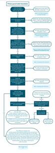
One of the key rules to understanding this flow chart is rule 29 Accuracy of water, water centre-line and irregular boundaries.
Accuracy of water boundaries
Water boundaries are not assigned a class (r 29(1)). However, with the exception of accepted boundaries (r 29 (3)), they must meet the accuracy requirements of rule 29(2). This applies to both primary and non-primary boundaries.
The accuracy of water boundaries is specified in a different way to the accuracy of right-line boundaries, that is, without a numerical tolerance to meet. Instead, the appropriate level of accuracy must be determined for each water boundary that is required to be defined by survey or is able to be adopted. This is done by considering the factors listed in rule 29(2).
This gives a surveyor the discretion to determine the appropriate level of accuracy for each specific situation. It is not always necessary for a field fix of a water boundary to be undertaken. In some circumstances using sufficiently accurate recent aerial photography, mapping imagery or other remote sensing technology that has been correlated with the cadastre may be suitable.
The position of a water boundary must be determined to a sufficient level of accuracy to take into account:
- the risk of overlap or ambiguity in boundaries, including a water boundary on the other side of the water body (r29(2)(a))
- any statutory requirement applying to the width or size of the related water bodies (r29(2)(b))
- An example is the 3-metre threshold that applies to marginal strips. If a stream is close to the 3-metre threshold and Part 4A Conservation Act 1987 is applicable, the accuracy will need to be sufficient to clearly establish whether the stream is over or under 3m
- the potential for the margin of the water body to move and for the water-related boundary to move or become permanent as a result of that movement (r 29(2)(c))
- An example is a dried-up stream where the original definition of the water boundary becomes primary evidence for the location of a boundary that is no longer movable
- the nature of the physical feature that defines the water body margin (r 29(2)(d))
- the value of the land and the intensity of the land use (r 29(2)(e)).
For example, after considering the factors above, a water boundary of an urban multi-million dollar property along a narrow stream would need to be determined to a higher level of accuracy than a water boundary of a 1000ha farm where the water body is in a steep sided gorge in thick bush.
The survey report must include information about the accuracy of the determination of the water boundary, including how the factors above have been taken into account (r 72(k)).
For any right-line boundary that intersects a water boundary:
- the bearing must be defined to class A, B, or C accuracies (as appropriate) (r 30(a))
- the accuracy of the distance must match the accuracy of the water boundary as determined under rule 29(2) and must be class D (r 30(b)).

Figure 1: Accuracy of a right-line boundary that intersects a water boundary
Accepting water boundaries
Accepting means to adopt an existing boundary without having to comply with an accuracy standard (r 15(1)). For water boundaries this means that the accuracy requirements of rule 29(2) do not apply (r 29(3)). Normally there is no requirement to assess for any movement of the water body. However, in some circumstances further investigation is required and the boundary may not be able to be simply accepted as land in the parcel may need to be removed due to specific legislative requirements. This includes requirements of the:
- Te Awa Tupua (Whanganui River Claims Settlement) Act 2017
- Manukau Harbour Control Act 1911
- Resource Management Act 1991 (s237A)
- Marine and Coastal Area (Takutai Moana) Act 2011.
The Surveyor-General does not have the authority under s47(5) of the Cadastral Survey Act 2002 to waive these legislative requirements by dispensation.
When a water boundary is able to be accepted, the accepted information must be faithfully copied from the source CSD. For a water boundary the source is the CSD that measured or defined the boundary (r 75(2)(b)). The boundary must not be copied from Landonline without verification. The exception to this is where rule 15(3) is used to accept the boundary of a balance parcel or residue parcel that is not in common with another new parcel on the survey. In this case the accepted boundaries can generally be captured using the process balance parcels functionality in Landonline. For further information see the heading ‘Accepting water boundaries of balance parcels and residue parcels’ below.
If a water boundary affected by ground movement is to be retained in its former position under rule 10(2) or (3), the boundary must be accepted rather than adopted (r 109(4)).
Accepting existing primary parcel water boundaries
An existing primary parcel water boundary may be accepted where it is part of a parcel that:
- meets the criteria in rule 15(2)(a) and (b) and is part of the balance of a title that is to remain limited as to parcels or remain a Hawke’s Bay interim title (r 15(2)(c)(iv))
- is a balance parcel or residue parcel (r 15(3))
- is a parcel over 100 ha (r 15(4)).
Please note that where there is a legislative requirement to remove part of the parcel which is under water, rules 15(2) and 15(4) are likely to not be applicable.
Accepting water boundaries of balance parcels and residue parcels
An existing boundary of a balance or residue parcel that is not in common with another new parcel on the survey may be accepted rule 15(3)). The meanings of balance parcel and residue parcel are given in Schedule 2 of the CSR.
Therefore, examples of where rule 15(3) might be used for an existing water boundary include where:
- part of a road is being stopped and the remaining portion of road includes a water boundary
- a residue parcel is created at the removal of limitations and has a water boundary
- a parcel of land is being defined between MHWS and MHWM to become common marine and coastal area
- an erosion parcel is being created.

Figure 2: Example of water boundary that is able to be accepted
Accepting non-primary parcel water boundaries
In all cases, a non-primary parcel boundary must be a water boundary if it coincides with an underlying primary parcel water boundary (r 46(3)).
In some instances, a water boundary forming the boundary of a non-primary parcel can be accepted. These are where:
- a new non-primary water boundary coincides with a water boundary of its underlying primary parcel and the relationship is inaccurately determined under rule 51 or rule 53
- an existing non-primary water boundary is within a primary parcel over 100 ha that has accepted boundaries (r 54)
- a new water boundary of a non-primary parcel over water coincides with an existing primary parcel water boundary (r 67).
Adopting water boundaries
Adopt means to incorporate in a CSD:
- information from an approved CSD (r 14(a))
- in the absence of suitable CSD information, information from an estate record held by the tenure system manager (r 14(b))
- information from a CSD that was lodged only for recording purposes, if the information is verified as complying with these rules (r 14(c)).
Therefore, only an existing boundary can be adopted.
An adopted water boundary must be copied without change from the CSD that measured or defined it (r 75), or the relevant estate record where no such CSD exists. Rule 88 requires the source to be annotated against an adopted water boundary “Adpt [CSD number]”.
The depiction must match the depiction from the source and must not be copied from Landonline without first checking that the depiction matches the source plan.
For more information see Water boundaries must not be copied from Landonline without verification
Note that “adopted from Landonline” or “DCDB” are not acceptable references. The stated source of the adoption must be the CSD that defined the water boundary.
In some instances, a water boundary in a digital CSD may have been distorted during plan generation. Verification against field notes, aerial photography from the time of the survey or other data sources may be required to determine the correct shape of the water boundary at the time of the survey. All water boundaries defined after the introduction of the CSR 2021 are required to include an accurate water boundary record for any new water boundary (r 71(f)). This is to allow the boundary to be accurately reproduced without any distortion that may have occurred in plan generation.
In some cases, it may be necessary or appropriate to plot the water boundary from the field notes or water boundary record associated with the source CSD. This decision must be explained in the survey report (r 72(k)).
An existing primary parcel water boundary may be adopted to define a new parcel when:
- the current position of the landward margin of the water body and the existing position as shown on the source are the same within the level of accuracy determined under rule 29
- the margin of a water body has moved as a result of accretion but entitlement to accretion is not being claimed on the CSD (r 10(2)(b))
- the margin of a water body has moved by a process other than accretion or erosion, for example, avulsion, artificial diversion or reclamation (r 10(3)(a)).
If a water boundary affected by ground movement is to be retained in its former position under rule 10(2) or (3), the boundary must be accepted rather than adopted (r 109(4)).
Determining whether an existing primary parcel water boundary can be adopted
Because a water boundary is ambulatory, it must be assessed for movement to confirm whether it is able to be adopted. The current position on the ground must be compared with the documentary position. An assessment must then be made as to whether the positions are the same within the accuracies expected by rule 29. This can be done using the following steps:
1 – Determine the documentary position:
The documentary position must be taken from the source of the boundary, that is the CSD that measured or defined the water boundary (r 14(a) & r 75). In the absence of a suitable CSD, information from an estate record held by the tenure system manager may be used (r 14(b)).
This might involve obtaining the field notes (or water boundary record for CSDs completed under CSR 2021) for the CSD that defined the water boundary. Also, historic aerial photography may provide information about the position of a water body over time. Retrolens is one source of such aerial photography:
Note that the Landonline position must not be assumed to be the documentary position.
2 – Determine the current position
The current position can be obtained in a number of ways, including from recent aerial photography, field inspection and field fixes. While field fixes may be required to verify positions, in many cases aerial photography may be sufficient to undertake an initial assessment.
Aerial photography, mapping imagery or other remote sensing technology needs to be up-to-date, of appropriate quality, clearly showing the relevant physical features, and capable of correlation with the cadastre.
3 – Compare the documentary and current positions
The documentary position and current position must be compared to determine whether there are any differences outside of the accuracies expected when the factors listed in rule 29(2) are considered.
If the documentary and current positions agree within the accuracies expected by rule 29, the water boundary may be adopted from the underlying CSD.
If the two positions do not agree within the accuracies expected by rule 29, further assessment must be made to determine why there is a difference, how any movement has occurred, and therefore whether the boundary is able to be adopted or not.
Key points to consider:
- where erosion has occurred, the land covered by water must be removed from the parcel (r 10(2)(a)), therefore the parts of the boundary that have eroded cannot be adopted
- where accretion has occurred and is not being claimed at this point in time the boundary may be adopted (r 10(2)(b))
- where avulsion, artificial diversion or reclamation has occurred, the boundary may be adopted or right-lined (r 10(3)). Note that adopting allows AMF rights and the potential to claim dry bed to be retained where-as right-lining may remove those rights
- where there is evidence that the water body is in a different position due to an inadequate original fix, the boundary must be defined by survey.
For further information see Better survey fix.
Adopting non-primary parcel water boundaries
As with accepted boundaries, a non-primary parcel boundary must be a water boundary if it coincides with an underlying primary parcel water boundary (r 46(3)). Therefore, some non-primary parcel water boundaries on new and existing non-primary parcels will be able to be adopted.
Defining water boundaries by survey
There are numerous circumstances where a water boundary will need to be defined by survey (r 13(a)). These include:
- a new primary parcel water boundary
- a new non-primary parcel water boundary that is not coincident with an existing boundary
- where a better survey fix is being undertaken
- when limitations are being uplifted or an application is being made to make a Hawke’s Bay interim title conclusive
- where accretion is being claimed
- when erosion has occurred
- when title is being sought for reclaimed land
- where a water body is being removed from a parcel
- where land has become or will become common marine and coastal area.
Additionally, if a water boundary is converted to a right-lined boundary it needs to be defined by survey.
Rule 6 sets out the duty of a surveyor when defining a boundary by survey.
When a water boundary is defined by survey, all of the relevant evidence must be gathered, interpreted and used to determine the position of the boundary to the accuracy required by rule 29.
For more information see Accuracy of water boundaries
The rules do not specify the methods used to survey water boundaries. A field survey of the new water boundary may not always be necessary. It may be possible to use aerial photography, mapping imagery or other remote sensing technology. Any data used must be up-to-date, of appropriate quality, clearly showing the relevant physical feature, and be capable of correlation with the cadastre.
If a field survey is carried out, there are various methods that can be used. The resource Tidal level information for surveyors may be useful when a tidal boundary is being surveyed:
Tidal level information for surveyors
Note that:
- a new water boundary is required to be defined by survey (r 13(a))
- a boundary point on a water boundary is not required to be referenced (r 31(a))
- a new boundary point being created on a primary parcel (including a boundary point on a water boundary) must be connected by one or more vectors to a cadastral survey network mark that meets the requirements of rule 17
- a boundary reinstatement survey must not be used to reinstate a boundary point on an existing water boundary (r 114(1)(a).
For more information see Boundary reinstatement restrictions
Better survey fix
A better survey fix is a survey of the current position of the landward margin of the water body which is deemed to be in the same position as it was when the original survey was carried out. Therefore, it is more than simply a fix of the boundary using more accurate modern day survey equipment. If the water body has been subject to movement since the original survey, a fix of the current position of the water body cannot be used as a better survey fix.
An investigation leading to a better survey fix would usually start following a comparison of the current position of the landward margin of the water body with the position shown in the underlying survey plan.
If these two positions do not coincide to the level of accuracy expected by rule 29(2), the next thing to investigate is whether the landward margin of the water body has moved by accretion, erosion, avulsion, artificial diversion or reclamation. This can involve talking to landowners in the area and looking at old field notes, surrounding survey plans, geological conditions and aerial photography.
If it is determined that the water body has not moved since the original survey that defined the water boundary, a better fix can be undertaken.
An exception request must not be made to replace the depiction based on the previous underlying plan for a better survey fix. The appropriateness of the better fix will be assessed by LINZ staff validating the CSD. The shape of the boundary in the cadastre will be updated once the CSD is deposited.
Where the better fix position of a water boundary spatially overlaps parcels on the opposite side of the water body in Landonline, each parcel that is overlapped must have the parcel action set as encroached.
For more details see Spatial overlap of parcels.
Example of a better survey fix:
The image below shows a water boundary defined in 1902 using the traverse and offset method.

Figure 3: Source CSD – surveyed in 1902
The original piece of land is 1.7500ha and the parcels on the new survey being undertaken are going to be around 0.1ha. The stream position is unable to be determined to a suitable accuracy from aerial photography due to vegetation therefore a field fix is undertaken.

Figure 4: Field fix overlaid on source plan
When compared with the existing water boundary position of the bank, there are differences outside of the accuracies expected by rule 29(2).
Plotting the original boundary from offsets confirms that the depiction on the source plan matches the field data.
It is noted that the current position was in good agreement with the existing position near the plotting offsets. However, between the offsets it differs outside of the expected accuracy tolerances that have been determined taking rule 29(2) into account.
With this evidence it can be concluded that the current fix of the bank is a better fix of the bank in its original position and therefore a better survey fix would be considered appropriate.

Figure 5: New survey incorporating better survey fix position
When limitations as to parcels are being uplifted
In some Land Districts in the past, it was the practice when uplifting limitations to simply survey the landward margin of the water body in its position at the time that the limitations were uplifted. This is not the case today.
Where a limited as to parcels title is bounded by a water boundary the normal rules for water boundaries apply. That is, any difference in the water boundary position between the historical definition for the title and the current position of the water margin has to be accounted for in the usual manner. This includes consideration of issues such as:
- accretion or erosion
- avulsion, artificial diversion or reclamation
- land becoming common marine and coastal area under s 237A RMA upon subdivision
- a better survey fix if evidence supports it.
See Better survey fix for more information
Right-lining an existing water boundary
An existing water boundary may be converted to one or more right-line boundaries if the margin of the water body has moved by a process other than accretion or erosion (r 10(3)(b)). Note that if AMF rights apply, the ability to claim dry bed later may be lost if the boundary is right-lined.
The right-lined boundary and associated boundary points must be defined by survey (r 13(d)) and referenced (r 31(a)). The boundary must be ground marked if it is class A (r 35). If it is class B it is exempt from ground marking under rule 35(1)( f) providing that none of the clauses of rule 35(2) apply. Occupation information will need to be provided (r 81(3)(a)) whether the boundary point is marked or not.
For more details see the heading 'Occupation and physical features' in Record of survey
New non-primary parcel water boundaries
Unless allowed to be inaccurately determined, accepted or adopted, a new water boundary on a non-primary parcel must be defined by survey.
For details of requirements for non-primary parcels being created over water please see:
Recording water boundaries
Because parcels bounded by water boundaries are subject to specific survey and legal considerations, it is essential that CSDs record current and former positions of relevant water body margins correctly, clearly, and unambiguously.
Field Information
All relevant field information must be included in the CSD, in a form that ensures permanent useability (r 71(e)).
Accurate record of new water boundary
The CSR 2021 introduced the requirement of an accurate record of the position of any new water boundary to be included in a CSD (r 71(f)).
Reporting about water boundaries
Clear reporting is essential to allow staff validating the CSD and future users of the dataset to understand decisions made during the survey.
Key requirements to note for water boundaries are:
- rule 72(a) requires the purpose for which the survey was conducted to be set out, including if it includes a claim for accretion or dry bed
- if a moveable marginal strip is included in a CSD rule 72(j) requires a description of the method used to determine its existence
- rule 72(k) requires the report to include information about the accuracy of the determination of any water boundary, water centre-line boundary, or irregular boundary, and the factors taken into account, as specified in rule 29(2)
- rule 72(l) requires any information as to why the physical margin of the water body is no longer coincident with an adopted boundary as provided for in rule 10.
For more information about the wider reporting requirements see Survey report information
Other useful information relating to water boundaries to provide in a survey report includes:
- whether the water boundary has been accepted, adopted or defined by survey and reasons for this
- whether there are legislative requirements that have contributed to the decisions made relating to the water boundary/water body including the Resource Management Act 1991, Marine and Coastal Area (Takutai Moana) Act 2011, Manukau Harbour Control Act 1911, Conservation Act 1987 or treaty settlement legislation
- where a better survey fix has been undertaken, why the existing water boundary is considered to be inaccurately defined and how it has been determined that the water margin has not moved from its original position.
Depiction of water boundary must be to scale on survey diagram and title diagram
On a survey diagram and a title diagram, a water boundary must be depicted at a scale that clearly shows its shape and relationship to other boundaries (r 85(a) & r 100).
Where the scale required to include the full boundary on a diagram could result in ambiguity or a lack of clarity (for example a long narrow stream where banks appear to merge), the water boundaries may be copied at a larger scale onto separate additional diagrams and, if necessary, distorted so that the information is clear and unambiguous.
Note that the depiction of a water boundary on a survey diagram must also be at a scale that is adequate to meet the accuracy required by rule 29(2) (r 85(a)).
Survey diagrams must include source annotation
Where a water or irregular boundary has been adopted under rule 10(2) or 10(3) an annotation of the source data “Adpt [CSD number]” must be depicted on the survey diagram clearly related to the relevant boundaries (r 88).
Where a water or irregular boundary has been accepted under rule 15 an annotation of the source data “Boundary accepted from [CSD number]” must be depicted on the survey diagram clearly related to the relevant boundaries (r 88).
Survey diagrams must include physical description
Where a physical feature (for example, bottom of bank or top of bank) defines a water boundary, this must be described on the survey diagram (r 88).
Refer to:
Title diagrams must include the legal boundary description
A title diagram must describe the legal water boundary (r 104). In the case of a parcel adjoining:
- the common marine and coastal area or tidal river, this will normally be MHWM or MHWS in the horizontal plane
- a non-tidal watercourse, this will normally be the left or right bank in the horizontal plane
- a lake, this will normally be the bank, shore or a defined water level.
The legal boundary description must not be confused with the description of the physical feature required to be depicted on the survey diagram by rule 88. For example, the legal boundary may be MHWM, MHWS, left bank, or right bank while the physical feature that defines the boundary could be top of bank or bottom of bank. If the legal boundary description and physical description are different, they must be clearly presented to avoid confusion between the two.
Refer to:
Diagrams must distinguish between MHWS and MHWM
The distinction between MHWM and MHWS is legally significant, especially for existing parcels with boundaries set at MHWM and the impact of statutes such as the Resource Management Act 1991 and the Marine and Coastal Area (Takutai Moana) Act 2011.
Where it is determined that the old position of MHWM and the new position of MHWS do not coincide, the depiction of the two positions must be clear and the land between the two positions dealt with correctly.
Where it is determined that the current position of MHWM and MHWS are coincident with each other and with the existing MHWM boundary (within the margins of accuracy as specified in rule 29(2)), the existing MHWM boundary may be adopted to represent MHWS. The diagram must be annotated to this effect. The label “MHWS=MHWM” is acceptable in this situation. In this case, the fact that the two boundaries coincide must be included in the survey report (r 72(k)).
Recording estate boundaries
The title plan must depict an estate boundary where it passes through the land under survey, clearly annotated with the estate record references (r 92(i)).
For examples of how this applies when accretion and dried bed are claimed see:
Water boundaries must not be copied from Landonline without verification
The shape and location of a water boundary to be used in a new CSD must be verified from the original source dataset, including where water boundary information is extracted from Landonline.
If the position from Landonline is not correct, adopting such a boundary in a new CSD will require capture (digitisation) from the source. When an existing inaccurately captured water boundary has been recaptured in a CSD, the new and more accurate water boundary will replace the lines that are in Landonline when the CSD is registered. Before linking in a non-Survey-accurate Digital Cadastre (non-SDC) area, the exception process may need to be invoked to better position any inaccurate Landonline nodes.
The only time that the Landonline position may be accepted without verification is where rule 15(3) is used to accept the boundary of a balance parcel or residue parcel that is not in common with another new parcel on the survey.
Refer to:
Exception requests
In some cases, especially in non-SDC areas, the existing water boundary depicted in Landonline may be inaccurate. Where the spatial cadastre is distorted or linking is problematic, an exception request may need to be raised to correct Landonline. An exception request can be made to change the spatial cadastre to better reflect the true shape and location of a water boundary as shown on the original source data. Exception requests may also be needed to split an existing water boundary for CSDs that only contain non-primary parcels.
Refer to:
- Create an exception request (New Landonline)
- Requests for Survey (New Landonline Survey support)
- The Exception process (Legacy Landonline)
Note that an exception request:
- can only be made to update existing boundaries in terms of the source data, not to reflect a better survey fix or change in the position of the boundary due to movement etc
- must be accompanied by detailed information as to the reasons that it is considered that the exception request is necessary. This information should also be included in the survey report.
Spatial overlap of parcels
In some instances, the depiction of a primary parcel with a water boundary will overlap the depiction of another primary parcel on the opposite side of a water body. These spatial overlaps do not impact on legal ownership. Instances of spatial overlaps may include:
- where the opposite sides of a stream or river were surveyed at different times (for example the left bank in 1890 and the right bank in 1923)
- where a river or stream has moved gradually and imperceptibly, and accretion is being claimed but the parcel or parcels on the other side of the water body have not been updated for the corresponding erosion
- when a better survey fix is undertaken.
See Better survey fix
Spatial overlap due to accretion
Where there is a spatial overlap in Landonline each parcel that is being overlapped needs to have the parcel action set as ‘encroached’ in Landonline. Spatial overlaps along with the estate boundary and estate record references for the parcel on the opposite side of the water body must not be shown in the CSD.
The left-hand diagram below shows the position of the boundaries of the Tutaetoko Stream prior to the survey. The right-hand diagram shows that accretion has occurred which spatially overlaps the water boundary of the parcel on the other side of the stream.

Figure 6a: Where there is a spatial overlap in Landonline due to accretion
Spatial overlap as a result of a better survey fix
The left-hand diagram below shows the position of the boundaries of the Tutaetoko Stream prior to the survey. The right-hand diagram shows a better fix which spatially overlaps the water boundary of the parcel on the other side of the stream.

Figure 6b: Where there is a spatial overlap in Landonline due to a better survey fix
End points and vector requirements
Each water boundary terminates at an end point. Each end point is required to have at least one vector included in the survey diagram, which may be a boundary vector (r 89(e)).

Figure 7: End points on a water boundary
The rules do not require intermediary points along a water boundary resulting from, for example, field ties, to be included in the CSD. This information can be included in the accurate record of the position of a water boundary required by rule 71(f).
For more information see Water boundary record
If intermediary points are captured in the CSD, perhaps to show the end points of a segment of accretion or erosion, then each point is required to be treated as an end point of a water boundary and have at least one vector included in the survey diagram (r 89(e)). This could be a vector to another boundary point or to a reference mark that is included in the survey.
In addition, separate segments of water boundary must be created between adjacent end points, rather than having a single line that passes over them.
Note that where the merge irregular boundary functionality is used in Landonline, a pseudo vector will be created in Landonline to preserve the spatial relationship. This vector will be included in the mark and vector report of the CSD but is not required to be depicted on the survey diagram.

Figure 8: Where a stretch of water boundary has more than two end points
Dispensation requests
Where it is considered that the requirements of the CSR 2021 or the Standard for lodgement of cadastral survey datasets (lodgement standard) is unreasonable or impractical, an application may be made to waive the requirement.
Note that:
- a dispensation cannot be issued to waive the requirements of legislation such as the Marine and Coastal Area (Takutai Moana) Act 2011 and the Resource Management Act 1991
- a dispensation is not required to allow water margins to be surveyed using methods other than traditional field fixes. The accuracy standards of rule 29(2) need to be considered when deciding what methodology is appropriate. See Accuracy of water boundaries.
Further information on recording water boundaries in specific situations
The articles listed below provide detailed information about recording water boundaries in specific situations:
Capture information related to water boundaries
The following articles may assist in the capture of water boundaries:
- Capturing an accretion parcel (New Landonline)
- Capturing an erosion parcel (New Landonline)
- Capturing movable marginal strips (New Landonline)
- Irregular lines (New Landonline)
- Edit irregular boundary attributes (New Landonline)
- Water, water centre-line and irregular boundary annotation (Legacy Landonline)
- Capturing an accretion parcel (Legacy Landonline)
- Capturing an erosion parcel (Legacy Landonline)
- Moveable Marginal Strips – capturing in Landonline (Legacy Landonline)
- Capture – irregular boundaries (Legacy Landonline)
- Irregular boundaries – not displaying in Layout Sheets (Legacy Landonline).
Recording water boundaries where the landward margin of the water body has moved
Water bodies are subject to various types of movement. How they are required to be dealt with under legislation and the CSR 2021 depends on a number of factors including the type of movement that has occurred as well as the application of some common law principles.
If the water boundary is able to be accepted, movement will not need to be accounted for in the survey.
For more information see Accepting water boundaries
In some situations there might be more than one type of movement that has occurred and therefore different parts of the water boundary may need to be treated differently. The extents of these parts will need to be clearly identified on the survey and title diagrams and the report will need to thoroughly explain the situation.
For example, the diagram below shows a stretch of coast that has been subject to both accretion and erosion. The erosion must be accounted for (r 10(2)(a)) and defined by survey. The landowner has opted to not claim accretion at this time and the position of the existing water boundary can be adopted for that portion (r 10 (2(b)).

Figure 9: A survey with erosion and unclaimed accretion
There are different requirements for the survey and title diagram depending on the type of movement. These are explained in the sections below.
Understanding the terms ‘existing water boundary’ and ‘former water boundary’
The terms existing water boundary and former water boundary are used in the rules. Their different meanings have implications to how the boundaries can be treated.
An existing water boundary is a water boundary of a live parcel. The title has a water boundary that hasn’t at any stage been converted to an irregular boundary.
A former water boundary is an irregular boundary that was formerly a water boundary, but has been converted to an irregular boundary. This has usually happened because the landward margin of the water boundary has been subject to movement other than accretion and erosion.
An existing water boundary becomes a former water boundary when the plan that converts it to an irregular boundary deposits. A notation is required on the title diagram that says “Former water boundary not coincident with water’s edge” (r 104).
Accretion
Where accretion has occurred to an ambulatory boundary outside of the accuracies determined by rule 29(2) and the water boundary is not able to be accepted under rule 15, there are two scenarios that may apply:
- the landowner does not wish to claim accretion
- the landowner wishes to claim accretion.
These scenarios are outlined below.
Where accretion is not being claimed
If the landowner does not wish to claim entitlement to accretion that has occurred at the time that the survey is undertaken, the existing water boundary may be adopted as a water boundary in its previously defined position (r10(2)(b)). The unclaimed accreted land will remain part of the adjoining water body for the purposes of the cadastre and title record. This means the boundary retains its water boundary status and accretion can be applied for at a later date.
The survey diagram and title diagram must:
- depict the adopted water boundary in its existing position at a scale that clearly shows its shape and relationship to other boundaries of the parcel (r 85 & r100). The adopted boundary must also be annotated with the adoption source “Adpt [CSD number]” on the survey diagram (r 88)
- prominently depict the annotation “Adopted boundary not coincident with water’s edge” clearly related to the relevant parts of the boundary (r 104).
The extent of the adjoining water body (usually a hydro parcel) will remain unchanged. Although the hydro parcel for the water body is not required to be depicted on the diagrams, its name or description is required on the survey diagram and title diagram (r 87 and r 103). Examples of a suitable description for a water body that does not have a name include “stream”, “river”, and “lake”.
Note:
- if a water boundary affected by ground movement is to be retained in its former position under rule 10(2)(b), the boundary must be accepted rather than adopted (r 109(4))
- if the boundary concerned is a tidal boundary, please refer also to:
Where current MHWS is seaward of existing MHWM or MHWS because of accretion or avulsion

Figure 10: Accretion not being claimed at this point in time
Where accretion is claimed
The registered owner of land held in a record of title under the Land Transfer Act 2017 may apply to have their record of title altered to record a water boundary change due to accretion.
For information about how to make a claim for accretion and the evidence required to support a claim, refer to the Registrar-General of Land's Accretion and Erosion Guideline 2025:
- Accretion and Erosion Guideline 2025 – LINZ OP G 01319
- Accretion and Erosion (Land registration Guide)
Where accretion has occurred to Māori land or Crown Land, advice will need to be sought from the Māori Land Court (Te Kooti Whenua Māori) or the administering Crown agency to determine if accretion can be claimed and the process for claiming it.
For information about accretion in relation to Legalisation CSDs please see:
- Accretion to land held under the Land Transfer Act 2017
- Land not held under the Land Transfer Act 2017
For information about accretion in relation to Crown subdivision CSDs please see:
Where the landowner wishes to claim accretion as part of the survey, the land abutting the water body and the land claimed as accretion must be combined as a single primary parcel. A successful accretion claim results in the area of accretion being added to the estate record of the adjoining land. A separate parcel for accretion must not be shown.
The new position of the water boundary will be required to be defined by survey (r 13(a)).
A survey diagram and title diagram must depict the:
- water boundary in its new position at a scale that clearly shows its shape and relationship to other boundaries of the parcel (r 85 & r 100)
- land being claimed as accretion with the description “Accretion” (r 87 & r 103) and with a separate area added as user added text on the title diagram only (r 41(3)). The total area of the new primary parcel must include the accretion area (r 97(3)(d))
- existing water boundary position as an estate boundary that passes through the new ‘dry’ parcel that is being created to include accretion (r 97(7)). The annotation “Accretion” is sufficient as the estate record reference for the accretion area. The existing boundary can be added to the CSD diagrams using the Select Existing Line tool in the Landonline plan generation screens.
The existing hydro parcel must be extinguished in Landonline and the remaining portion of the adjoining water body will be captured as a balance hydro parcel. Its extent need not be depicted in full on the survey diagram and title diagram (r 83(a) and r 97(1)(b)). As an abutting parcel it must be referenced with its name or description on the survey diagram and title diagram (r 87 and r 103)). Examples of a description of an unnamed water body include “stream”, “river”, and “lake”.
The survey report must include the purpose for which the survey was conducted including that the survey is for a claim for accretion (r 72(a)).
Refer to:
- Recording water boundaries
- Capturing an accretion parcel (New Landonline)
- Capturing an accretion parcel (Legacy Landonline)

Figure 11: Depiction of accretion on title diagrams
Note that in some circumstances the new water boundary of land that has accreted will overlap a parcel on the other side of the water body.
For information on how this needs to be dealt with please see Spatial overlap of parcels.
Erosion
Where erosion has occurred outside of the accuracies determined under rule 29(2), and the boundary is not able to be accepted under rule 15, the erosion must be accounted for (r 10(2)(a)). The new position of the water boundary is required to be defined by survey (r 13(a)).
The erosion must be included in the CSD as a residue parcel. It is the residual portion of a primary parcel that is being defined as part of the bed of a lake, a river or parcel of the common marine and coastal area (Schedule 2 CSR 2021).
If the existing water boundary on the residue parcel is not in common with another new parcel on the survey it may be accepted under rule 15(3).
The survey diagram and title diagram must depict:
- the erosion as a separate residue parcel, except where the erosion is included in a parcel that is being defined as common marine and coastal area. An area is not required. This residue parcel must be described as erosion without any other description or appellation (r 87 and r 103). For erosion in tidal areas please also see:
Where current MHWM is inland from existing MHWM boundary because of erosion - the new water boundary in its new position at a scale that clearly shows its shape and relationship to other boundaries (r 85 & r 100)
- the existing water boundary as an accepted boundary (r 15(3), r 85 & r 100)
- the name or (if no name is available) a simple description (such as “sea”, “stream”, “river”, or “lake”) for the water body that abuts a new parcel (r 87 & r 103).
The erosion parcel must have the parcel intent ‘erosion’, except when it is incorporated into a larger parcel with other land to become common marine and coastal area.
Refer to:
- Recording water boundaries
- Capturing an erosion parcel (New Landonline)
- Capturing an erosion parcel (Legacy Landonline)

Figure 12: Erosion as a residue parcel
Avulsion, artificial diversion and reclamation
If the margin of the water body has moved by avulsion, artificial diversion or reclamation, the water boundary will not have moved to the new position, but remains in its original position.
In some cases, the water boundary may be able to be accepted in its original position.
For further information on when boundaries can be accepted see Accepting water boundaries
Where the water boundary cannot be accepted, its original position can be adopted or, if preferred, converted to one or more right-line boundaries (r10(3)).
Reclamation
Where a CSD is being prepared to seek title to land that has been reclaimed from the sea or a lake or river, an existing water boundary along the landward margin may be:
- adopted and set in its previously defined position as an irregular boundary, or
- converted to one or more right-line boundaries. (r 10(3)).
Avulsion and artificial diversion, including claims for dry bed
When avulsion or artificial diversion has occurred, the water boundary does not automatically move to the new position of the water margin.
Where the bed of a water body has become dry due to avulsion or artificial diversion a claim for dried bed may be able to be made when the adjoining land has AMF rights.
The following resource issued by the Registrar-General of Land provides further information about how to make a claim and the evidence required:
Application to bring land under the Act – Dry Riverbeds and Streambeds Guideline 2018 – LINZG20782
For avulsion in coastal areas see:
Where current MHWS is seaward of existing MHWM or MHWS because of accretion or avulsion
When a survey of the land is carried out, a landowner with AMF rights can choose whether to claim dried bed or not.
Where dry bed is not claimed
Where there is no possible claim to dried bed or the decision has been made not to claim dry bed at the time of the survey, the existing water boundary may be:
- set in its previously defined position as an irregular boundary (r 10(3)(a))
- converted to one or more right-line boundaries (r 10(3)(b)).
Where a dried bed claim could be made later, it is recommended that the boundary is converted to an irregular boundary using rule 10(3)(a), rather than right-lining the boundary which may remove the rights to make a claim.
The unclaimed dried bed will remain part of the adjoining water body for the purposes of the cadastre and land title register.
The survey diagram and title diagram must:
- Depict the water boundary either:
- in its existing position at a scale that clearly shows its shape and relationship to other boundaries of the parcel (r 85 and r 100), or
- as one or more right-line boundaries that must be defined by survey (r 13(c)), referenced (31(a)), have occupation provided (81(3)(a)) and in the case of class A be ground marked (35(1)(f))
- When the boundary is set as an irregular boundary, prominently depict the annotation “Former water boundary not coincident with water’s edge” clearly related to the relevant boundaries (r 104). The adopted boundary must also be annotated with the adoption source “Adpt [CSD number]” on the survey diagram (r 88).
The extent of the adjoining water body (usually a hydro parcel) will remain unchanged. Although the hydro parcel for the water body is not required to be depicted on the diagrams, its name or description is required on the survey diagram and title diagram (r 87 and 103). Examples of a suitable description for a water body that does not have a name include “stream”, “river”, and “lake”.
If a water boundary affected by ground movement is to be retained in its former position under rule 10(3)(a), the boundary must be accepted rather than adopted (r 109(4)).

Figure 13: Where dry bed is not being claimed
Where dry bed is claimed
Where a dried bed is being claimed, the bed may either be depicted in conjunction with the adjoining land or as a separate primary parcel. The requirements for these two scenarios are outlined below:
Where dry bed is being claimed and is depicted with the adjoining land
Where a claim is being made for a dried up water bed, the area being claimed may be depicted with the adjoining land in a single primary parcel.
The survey diagram and title diagram must depict:
- the new primary parcel boundaries as marked right-line boundaries (r 38(1)(a) & r 35(1))
- the existing or former water boundary as an estate boundary that passes through the new ‘dry’ parcel that is being created to include the dry bed (r 97(7))) and the estate record references, including that for the dried up water bed (for example, dry stream bed)
- the name of the balance water body parcel abutting the new parcel, or a simple description if no name is available ((r 87 & r 103)). Examples of a description of an unnamed water body include “stream”, “river”, and “lake”).
The adjoining water bed that is not being claimed will be a balance parcel. It will be captured with a parcel intent of hydro and must be included in the CSD (to enable the dry land portion to be removed) but its extent need not be depicted in full on the survey diagram and title diagram (r 83(a) and r 97(1)(b)). As an abutting parcel it must be referenced with its name or description on the survey diagram and title diagram (r 87 and r 103 )). Examples of a description of an unnamed water body include “stream”, “river”, and “lake”.

Figure 14: Stream bed being claimed with adjoining land
Where a dry bed is being claimed and is depicted as a separate primary parcel
Where a claim is being made for dried up water bed, the area being claimed may be depicted as a separate primary parcel.
The survey diagram and title diagram must depict the bed being claimed as a parcel with:
- the water boundary either
- adopted and depicted in its existing position at a scale that clearly shows its shape and relationship to other boundaries of the parcel (r 85 & r 100), or
- as one or more right-line boundaries that must be defined by survey (r 13(c)), referenced (31(a)), have occupation provided (81(3)(a)) and in the case of class A be ground marked (35(1)(f)).
- when the boundary is set as an irregular boundary, prominently depict the annotation “Former water boundary not coincident with water’s edge” clearly related to the relevant boundaries (r 104)
- all new boundary points on the new boundaries must be marked (r 35(1))
- an appellation (for example, Lot 1) and an area (r 41(3)).
The portion of the water body that is not being claimed will be a balance parcel. It will be captured with a parcel intent of hydro and must be included in the CSD (to enable the dry land portion to be removed) but its extent need not be depicted in full on the survey diagram and title diagram (r 83(a) and r 97(1)(b)). As an abutting parcel it must not be given an appellation but will be referenced with its name or description on the survey diagram and title diagram (r 87 and r 103)). Examples of a description of an unnamed water body include “stream”, “river”, and “lake”.

Figure 15: Stream bed being claimed as a separate parcel
Recording water bed excluded from a new title
Where the territorial authority does not require the streambed to vest under s 237A of the RMA, a landowner subdividing land may choose to exclude a previously undefined watercourse in an existing primary parcel and use the banks as the boundary between new parcels. If it is the intention that a new title will not issue for the water course the survey diagram and title diagram must depict the:
- new water boundaries at a scale that clearly shows their shape and relationship to other boundaries (r 85 & r 100)
- watercourse as a residue parcel. This residue parcel must not have an appellation but must show its name or a description (r 87 & r 103). Where the water course is unnamed, examples of a suitable description include “stream”, “river”, and “lake”. An area is not required (r 41(1)).
The residue parcel will have the parcel intent hydro.
A parcel of stream bed must not be given an appellation (for example Lot 3).
The survey report must confirm the intention to exclude the bed from any new title to be issued and information about the accuracy of the determination of any water boundaries (r 72(a) & 72(k)).

Figure 16: A stream being a residue parcel
Note: the above illustrates one method of dealing with stream beds. Different requirements will apply where alternative methods, such as including the stream within one of the new parcels, have been used.
Recording water bed to vest under sections 237A or 239(1)(c) RMA 1991
Note that this section does not deal with land required to be shown as part of the common marine and coastal area under s237A(1)(b). Refer to:
Land becoming common marine and coastal area under s 237A upon subdivision
Where a parcel that is part of the bed of a river or lake is to vest under sections 237A(1)(a) or 239(1)(c) of the Resource Management Act 1991 (RMA), the survey diagram and title diagram must depict:
- the land to vest as a new primary parcel
- any new water boundary at a scale that clearly shows its shape and relationship to other boundaries (r 85 & r 100)
- an existing or former water boundary that is common with the adjoining water body as an accepted boundary (r 15(3), r 85 & r 100).
The primary parcel of land to vest must be treated in the same manner as other primary parcels and must be captured and have an appellation. It must be depicted on the survey diagram and title diagram (r 83(c) and 97(3)(b) and have an area on the title diagram (r 97(d)).
Refer also to Accepting existing primary parcel boundaries
The parcel must have the parcel intent “Vesting on deposit in the Territorial Authority (Sec 237A(1)(a) RM Act)” or “Vesting on deposit in the Crown (Sec 239(1)(c) RM Act)” as applicable. Upon vesting and integration into the spatial cadastre, the appellation will not be visible.
The adjoining hydro parcel, where applicable, need not be fully depicted but must be named or described (r 87 & r 103). Examples of descriptions are “sea”, “lake”, “river”.
The title plan must include a notation regarding a vesting of land (r 103).
For further information refer to Annotations and ‘user added text’

Figure 17: Example of river bed vesting under s 237A or 239(1) RMA
Recording movable marginal strip and esplanade strip parcels
This section contains information about:
- movable marginal strips created pursuant to Part 4A of the Conservation Act 1987
- esplanade strips created pursuant to Part 10 of the Resource Management Act 1991 (RMA).
Please note that there were some strips created during specific time periods under the Conservation Act 1987 and the Resource Management Act 1991 that are not movable. These are discussed below.
Movable Marginal Strips
A movable marginal strip:
- is created next to the foreshore or a qualifying lake, river or stream when the Crown disposes of land. The requirements, including the criteria for a ‘qualifying’ waterbody, are specified in Part 4A of the Conservation Act 1987.
- is land owned by the Crown and administered by the Department of Conservation.
- moves when the water body moves. Section 24G of the Conservation Act 1987 provides that where the water margin alters for any reason and the alteration effects an existing marginal strip, a new marginal strip shall be deemed to have been reserved simultaneously with each and every such alteration, and the old strip is extinguished.
- that is to be shown in a new CSD is to be treated as a non-primary parcel within the relevant underlying primary parcel. This is to give effect to section 24D of the Conservation Act 1987, which contemplates the land in a record of title being defined as if the marginal strip provisions in the Conservation Act did not exist. This means that although records of title appear to include land occupied by marginal strips, they are not actually part of the land comprised in the title.
Please note that:
- marginal strips that were created under s24 Conservation Act 1987 between 1 April 1987 and 10 April 1990 or reserved under s24(3) Conservation Act 1987 are not movable.
s24(3) Conservation Act 1987 - strips reserved under s24(3) Conservation Act 1987 include Crown land reserved from sale under s58 of the Land Act 1948 or other similar sections in earlier legislation. These parcels were often noted as ‘Crown land reserved from sale (marginal strip)’ or sometimes referred to as ‘Section 58 strips’. These parcels were generally surveyed as, and remain as, separate primary parcels.
- strips that were reserved under s24 Conservation Act 1987 between 1 April 1987 and 10 April 1990 are similar in all respects to a movable marginal strip except that the movable provisions do not apply. These marginal strips were not created as parcels and were shown and captured in the same manner as a movable strip. The landward boundary of these strips remains fixed in the same position as it occupied at the time the strip was reserved.
Refer also:
Capturing movable marginal strips (New Landonline)
Esplanade strips
An esplanade strip:
- is created along the mark of mean high water springs of the sea, the bank of a river, or the margin of a lake when land is subdivided or reclaimed, or at any time by agreement between a landowner and a local authority. The requirements are specified in Section 230 of the RMA:
Section 230 of the RMA - created on a subdivision or reclamation is required to be shown on the resultant CSD (refer to sections 237 and 245 RMA)
- created by agreement is typically not shown in a CSD.
- is owned by the landowner. The territorial authority gains an interest in the land but does not own it (section 232 RMA).
- moves when the water body moves. Section 233 of the RMA provides that where the water margin alters for any reason and the alteration effects an existing esplanade strip, a new esplanade strip shall be deemed to have been created simultaneously with each and every such alteration within the allotment.
Please note that:
Esplanade strips created by agreement between 17 December 1997 and 31 July 2003 do not move due to an anomaly in the law which was corrected in the Resource Management Amendment Act 2003. Any change in position is dealt with by cancelling the existing agreement and registering a new one.
Historic depiction of moveable marginal strips and esplanade strips
Until the Rules for Cadastral Survey 2010 came into force, neither movable marginal strips nor esplanade strips were depicted as parcels.
The locations and extent of new strips were usually indicated by notation against a water boundary (or internal water body) in a CSD diagram. Sometimes these strips (particularly marginal strips) may not have been shown or otherwise identified on subsequent surveys. Investigation of relevant records will be required to establish whether or not strips were created.
The images below show a variety of ways in which esplanade strips and marginal strips were identified before the Rules for Cadastral Survey 2010 came into force.


Figure 18 – Excerpts showing marginal strip notations added to SO 1384 Otago in 1992

Figure 19 – Marginal strip notation on SO 368536 (2006)

Figure 20 – Marginal strip notation on SO 389141 (2007)

Figure 21 – Esplanade strip notation on DP 87652 (Wellington) in 1999

Figure 22 – Esplanade strip notations on DP 403139 in 2008
Requirement to include movable marginal strips
New movable marginal strips
As the result of a government directive in 2007, marginal strips are required to be surveyed and depicted on a CSD before the disposal of land by the Crown. The Department of Conservation has produced a guideline to assist surveyors to identify water bodies that qualify for marginal strips when the Crown disposes of land.
Refer to The identification of water bodies that will qualify for marginal strips
Existing movable marginal strips
Existing movable marginal strips are not required to be shown on a CSD dealing with land held under the Land Transfer Act 2017 that is subject to Part 4A Conservation Act 1987 (see s24D(7) Conservation Act 1987). However, surveyors are encouraged to show any existing movable marginal strips relating to the land under survey so that the true extent of the land in a record of title is clearly identifiable on the title diagram.
An assessment will need to be made to determine whether:
- the associated water body continues to qualify for the reservation of a marginal strip under section 24(1) of the Conservation Act 1987
- the water boundary position from a former CSD is able to be adopted or accepted, or whether it needs to be defined by survey in its new position due to movement of the associated water margin. Note that under section 24G a new strip is deemed to have been reserved with any alteration of the water margin irrespective of the reason the movement has occurred. This means that for the purpose of determining the new position of the marginal strip there is no requirement to assess why the water margin has moved.
For further information see:
Requirement to include esplanade strips
New esplanade strips
Where an esplanade strip is required to be created on a subdivision, it must be shown on the CSD before the territorial authority is able to give section 223 RMA approval (s 237 RMA). Similarly, an esplanade strip required to be created on a reclamation must be shown on the CSD before the consent authority can give section 245 RMA approval.
Existing esplanade strips
A CSD must show a new non-primary parcel for an existing esplanade strip if the strip has previously been defined in an approved CSD – see rules 97(5) and 97(6)(c).
Surveyors are encouraged to also show a new non-primary parcel for an existing esplanade strip over the land under survey that has not previously been defined in an approved CSD, including those created by agreement. This is to satisfy a growing expectation that the extents of the rights and restrictions of landowners are able to be displayed graphically.
An assessment will need to be made to determine whether the water boundary position from a former CSD is able to be adopted or accepted, or whether it needs to be defined by survey in its new position due to movement of the associated water margin. Note that under s233 of the RMA a new strip is deemed to have been created with any alteration of the water margin irrespective of the reason the movement has occurred. This means that for the purpose of determining the new position of the esplanade strip there is no requirement to assess why the water margin has moved.
For further information see:
Requirements relating to depiction of marginal strips and esplanade strips
The rules specify requirements for the definition and depiction of marginal and esplanade strips when they are included in a CSD.
Where a marginal or esplanade strip is depicted, the following apply:
- the strip must be depicted as a non-primary parcel abutting a water boundary.
- an esplanade strip must be depicted with the width(s) specified by a rule in a district plan or resource consent (ss108, 220 & 232 RMA). It is the responsibility of the territorial authority to ensure that the strip complies with the district plan, resource consent and RMA.
- a marginal strip must be depicted with a width of 20 metres from the water boundary, or with such other width(s) as approved by the Minister of Conservation (ss 24A & 24AA Conservation Act 1987).
- marginal strips being created on the renewal of a Crown pastoral lease renewal must be defined in accordance with the “Survey Prescription for surveys recording movable marginal strips for the purpose of Crown pastoral lease renewals”. This document will be provided as part of the contract to undertake this work.
- a strip cannot be offset from a water body that is separated from the underlying parcel
Refer to Land not abutting a water boundary - if the underlying primary parcel is being surveyed and the boundary is an adopted water boundary that does not coincide with the present position of the water margin, the strip must be depicted as abutting that adopted water boundary. This would be the case if rule 10(2)(b) was being used because accretion has occurred but is not being claimed.
- if the existing primary parcel water boundary is becoming an irregular boundary or right-line boundary under rule 10(3)(a) or 10(3)(b) respectively, the strip should be depicted within the parcel, if the margin of the water body has moved within the parcel. This would occur when land in the parcel has been lost due to avulsion. Where the water margin has moved away due to a process other than accretion, no strip is required to be shown where the landward margin of the water body is not within or abutting the parcel.
When an esplanade strip or moveable marginal strip is included in a CSD, the survey diagram and title diagram must:
- show the strip as a non-primary parcel contained within its underlying primary parcel (r 84 & r 99)
- show the landward boundary of the strip as an irregular boundary except where it coincides with an underlying parcel boundary (r 46))
- depict the width of the strip on the title diagram (r 103)
- depict the water and irregular boundaries at a scale that clearly shows their shape and relationship to other boundaries of the parcel (r 85 & r100).
On a survey diagram, the water boundary and the landward irregular boundary of the strip must be at a scale that is adequate to meet the accuracy required by rule 29(2) (r 85(b)).
For more information see:
Examples of depiction of marginal and esplanade strips

Figure 23: Depiction of a marginal strip with a fixed width

Figure 24: Depiction of an esplanade strip with width restricted by abutting primary parcel

Figure 25: Depiction of an esplanade strip with variable width
Pt 4A marginal strip notation required on the title diagram
Rule 103 specifies when the notation “Subject to Part 4A Conservation Act 1987” must be depicted on a title diagram. This requirement applies regardless of whether there is a water body present.
Surveyors are responsible for determining whether the land under survey is subject to Part 4A of the Conservation Act 1987. Note that existing CSDs may have omitted the notation.
Appellation of marginal or esplanade strip on CSD diagrams
The appellation of the strip must be depicted on a survey diagram and title diagram (r 83(c) and r 97(3)(b)) either as esplanade strip or marginal strip (r 43) with a unique letter(s) (r 45). Examples are 'marginal strip A' and 'esplanade strip B'. This appellation may be abbreviated on the diagram providing it is unique to the dataset (for example, 'A' or 'B').
Area of marginal or esplanade strip on Title diagram
The area of the primary parcel must include the area of the marginal strip that lies within it (r 41(1)). This is a consequence of the legislation which requires the parcel area to be as if the marginal strip does not exist.
If the CSD includes a separate area for a marginal strip in addition to the area of the underlying primary parcel, it must not be shown on the title diagram (r 97(3)(d)). This is to ensure that anyone looking at the title diagram would not be misled into thinking that the area of the underlying primary parcel is the sum of the two areas shown on the title diagram.
A separate parcel area may be shown for an esplanade strip on the title diagram, but if one is shown, it must not create any ambiguity about the area of the underlying primary parcel (r 91(a)).
Land not abutting a water boundary
A 1999 court decision ruled that a marginal strip under s24 of the Conservation Act 1987 is not created if Crown land being disposed of lies within 20 metres of a water margin but does not abut the margin.