
Boundary reinstatement surveys
A boundary reinstatement survey is a survey that places a boundary mark on a boundary point or line already defined in an approved CSD and does not create any new parcels (r 112).
A boundary reinstatement CSD must be lodged within 6 months of placement of a boundary mark (r 113).
When a boundary position has been repeatedly re-marked (for example, due to ongoing site works removing the mark), a CSD must be lodged within 6 months of the first time the position was marked. The date of survey (r 119(c)) must reflect the last placement of a mark in that position.
If something other than a boundary mark as defined by rule 36 has been used to set out an existing boundary point (for example, a stake or painted cross), it is not necessary to lodge a boundary reinstatement CSD.
Note that if a dumpy peg is placed, then the dumpy peg is considered to fall within the criteria of a boundary mark (r 36(1)(e)).
Boundary reinstatement restrictions
A boundary reinstatement survey cannot be used where the boundary point being reinstated is (r 114(1)):
- on a water, water centre-line or irregular boundary
- on a boundary in a record of title that is limited as to parcels
- on a Māori land CSD that is annotated ‘computed plan - areas and boundaries not defined by survey’
A full land transfer survey is required when placing a boundary mark in these situations.
Types of boundary reinstatement CSDs
There are two types of boundary reinstatement CSDs, simple and complex. The Landonline survey purposes are ‘Simple Boundary Reinstatement CSD’ and ‘Complex Boundary Reinstatement CSD’.
A complex boundary reinstatement CSD must be used where the boundary point is (r 114(2)):
- subject to conflict
- affected by ground movement
- insufficiently defined
- defined on a diagram on transfer.
A complex boundary reinstatement CSD may change the location or extent of a boundary but does not update the record of title. A full land transfer survey is required to update the title.
All other boundary reinstatement surveys may be recorded on a simple boundary reinstatement CSD.
A decision tree has been included in the rules to illustrate where reinstatement surveys can be carried out and whether it is simple or complex (r 114(5)).
Simple boundary reinstatement and CSD requirements
A simple boundary reinstatement CSD is a simplified CSD with reduced requirements for the efficient recording of information where a new title will not issue. The essential requirements are:
- a survey report (r 118)
- a record of survey (r 119)
- a dataset description (r 117(c))
- relevant field information (r 117(d)).
Survey report
A simplified survey report template has been developed to record only the information required by rule 118 and the Standard for lodgement of cadastral survey datasets LINZS70000.
The automated survey report in Landonline can be used, but it is not tailored to the reduced requirements specifically for simple boundary reinstatement CSDs.
Record of survey
The record of survey (r 119) is designed to mainly be a digital set of information created in third party software for upload to Landonline. Other than the reinstatement diagram and occupation, all information must be fully captured in Landonline.
Boundary vectors between reinstated boundary points must be captured in Landonline using the ‘Nbdy’ layer and given a bearing and distance type of ‘Rein Adopted’ or ‘Rein Calculated’. Rein Adopted is used when the bearing or distance of a reinstated boundary is adopted. Where a reinstated boundary is recalculated, Rein Calculated must be used. The vector must also be assigned an appropriate survey class.
These reinstated boundary lines will be tested by Landonline to the correct accuracy standard and display with a thick line width in plan generation.
A reinstatement diagram (r 120) which is a simplified survey diagram does not need to show all the information contained in the record of survey. Future surveyors will need to use the digital data, reinstatement diagram and survey report to interpret the boundary definition.
The below reinstatement diagram shows the minimum information as specified in rule 120. Note that adopted vectors or bearings and distances do not need to be shown. For clarity, the REIN line style should be used where an old peg has also been surveyed and is located on one, or both ends of a boundary under survey. The REIN line style is not used where only one peg is placed or found, on a boundary. The benefit of using the REIN line style is to highlight those boundaries that are the subject of the survey and to enable the accuracy of boundary points to be tested as required by rule 27(1).
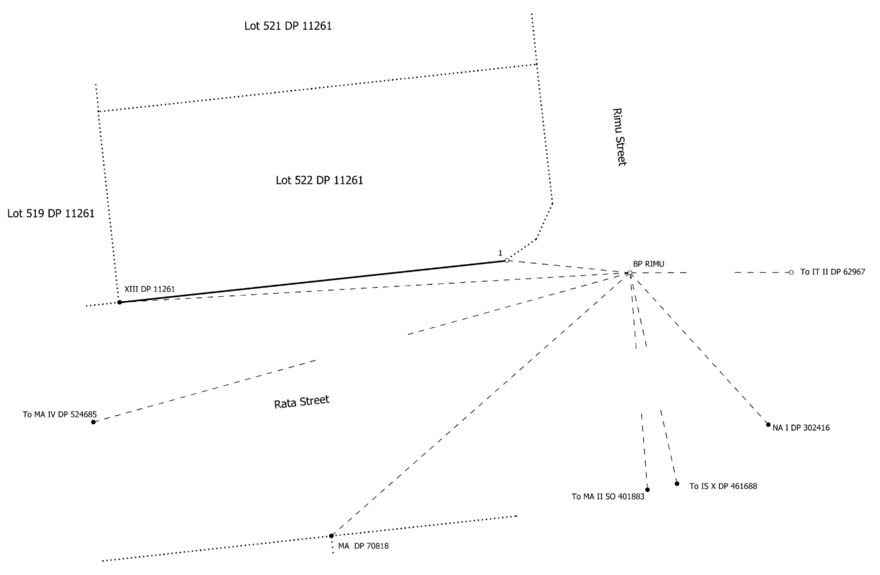

Figure 1: Reinstatement diagram
The reinstatement diagram can be produced using third party software or created using Landonline plan generation tools.
Where the reinstatement diagram is prepared in third party software, it must be attached as supporting document type ‘Survey Data Graphic’. It is also still necessary to enter layout plan sheets and add a note ‘See Survey Data Graphic’ against survey sheet 1.
For an example of a simple boundary reinstatement CSD see:
Accuracy standards
The same accuracy standards specified under Part 4 Field survey apply to boundary reinstatement surveys.
Dataset description
The dataset description should read:
- ‘Reinstatement of Lot 6 DP 4567’ or
- ‘Reinstatement of southern boundary Lot 6 DP 4567’.
Field information
All relevant field information relating to the placement of the boundary marks must be attached as a supporting document type ‘Field Information’.
For more information see Content of a CSD - Field Information
Complex boundary reinstatement and CSD requirements
Where a complex boundary reinstatement survey is undertaken the requirements are the same as for a full land transfer survey, but without a title plan. The survey must comply with Rules 16, 18 to 37 and the CSD with rules 71 to 91.
Example of a complex boundary reinstatement CSD
SO 577060 is a definition of 2 parcels of land held in the same title. One parcel was previously defined on a diagram on transfer and therefore this survey is a complex boundary reinstatement as per rule 114(2)(d).
Boundary reinstatement of affected boundaries
A complex boundary reinstatement CSD can be used to record the placement of a boundary mark on an affected boundary (r 114(2)(b)). Where ground movement results in the creation of a new boundary angle, that angle may be marked and recorded on a complex boundary reinstatement CSD.
Boundary reinstatement of a Hawke’s Bay interim title
A simple boundary reinstatement CSD can be used to record the placement of a boundary mark on a Hawke’s Bay interim title. Where the boundary is subject to conflict or insufficiently defined in an approved CSD (r 114(2)(a) and (c)), a complex boundary reinstatement CSD must be used to record the placement of a boundary mark.