What is a diagram on transfer?
A “Diagram on Transfer” is a diagram contained in a transfer document (or other instrument), illustrating a portion of land in a title that has been transferred out. Historically minor subdivisions and boundary adjustments were sometimes undertaken using a diagram on transfer rather than a full survey plan. These diagrams depicted the new parcel(s) with boundary dimensions and, occasionally, some elements of survey definition. While this practice has now ceased, there are still many titles derived from diagrams on transfer that surveyors may need to deal with.
Key terms
Conveyance
The transfer of ownership of property, especially under the Deeds Registration System, from one person to another; or the written instrument that effects such a transfer.
Deeds Registration System or Deeds System
A system for registration of deeds or instruments relating to land that was established in New Zealand in 1841. The effect of registration under this system was to give priority to the registered instrument over all unregistered instruments or instruments registered at a later date. This system continues under the Deeds Registration Act 1908 and registration can still occur, although very rarely. It has been superseded by the Torrens land title system under the Land Transfer Act 2017 and its predecessors.
Evidential Weight
In terms of the hierarchy of evidence, multiple pieces of evidence that support each other and suggest a possible boundary determination compared against competing boundary evidence to determine the set with the greatest cumulative weight of certainty. Evidence with a higher probability of being correct, or more certainty of being correct is considered to have greater weight of emphasis allocated to it.
Instrument
A legal document used to create, transfer or otherwise affect an estate or interest in land, such as a freehold estate, lease, mortgage or easement. Under the Land Transfer Act 2017, an instrument only has effect when it is registered in accordance with that Act.
Order of Priority
When defining unsurveyed boundaries originating from a diagram on transfer, the documentary dimensions of the first parcel transferred out of the parent title have priority as the principal evidence for definition and must be exactly respected.
Part-cancelled Record of Title
A record of title that is part cancelled will have the words "Part-Cancelled" written across the top of the record. A part-cancelled record of title occurs when part of the land contained on a record of title is removed so that only part of the land listed in the legal description remains.
Transfer instrument
Used primarily to register the transfer of an estate or interest in land from one party to another under the Land Transfer Act 2017. It was previously referred to as a memorandum of transfer.
Priority of diagram on transfer for definition
When defining unsurveyed boundaries originating from a diagram on transfer, the documentary dimensions of the first parcel transferred out of a parent title have priority as the principal evidence for definition and must be exactly respected. The assumption of the principle of order of priority, implicit in Australian Law and equally applicable to New Zealand Law, is that the original owner has given up all occupational rights to the portion of land transferred out by dispensing with a survey of that land.
If a later survey identifies a discrepancy in the parent parcel dimensions, the balance part must accept whatever remains, be it an excess or a shortage. There can be no pro-rata adjustment of the transferred dimensions.
Where a number of transfers have been carried out in this way, a chronological order of priority applies and the final part of the parent parcel must accept whatever balance remains.
Figure 1 below illustrates the principal of order of priority when successive parcels of land are transferred out of a parent parcel by means of diagram on transfer.
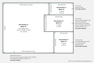
Figure 1: Diagram illustrating the principle of the order of the priority
Identifying a diagram on transfer
Parcels that were subdivided by way of a diagram result in the appellation of each new parcel having the prefix 'Part' (or 'Pt') of the parent appellation. However, it is important to note that not all parcels that contain the prefix ‘Part’ are created by diagram on transfer and may be due, for example, to the record of title (RT) being part-cancelled by a transfer or legalisation of part of the title defined by survey and shown on a survey office or deposited plan.
In order to confirm the parcel under survey has been created by diagram on transfer it is necessary to identify when and how the 'Part' appellation was created.
The first step is to identify the part parcels that comprise the land under survey. For example, Figure 2 below shows two parcels with the appellation Part Lot 3 DP 5544 (circled in red).
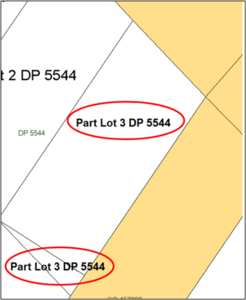
Figure 2: Part Lots 3 DP 5544 - Landonline spatial view
The larger Part Lot 3 DP 5544 is held in RT OT6A/1462, while the smaller parcel is held in RT 935938, as shown in Figure 3 below.

Figure 3: RT 935938, Part Lot 3 DP 5544
The second step is to search the historic titles until the title for the whole of Lot 3 DP 5544 is located. In the above example, a search of the prior titles for RT 935938 shows that this Part Lot 3 DP 5544 was previously held in RT OT6A/1245. A search of RT OT6A/1245 leads to the prior title OT325/238, shown below as Figure 4.
The areas circled red on Figure 4 show the appellation of this parcel being Lot 3 DP 5544 (not a part lot), which indicates that OT235/238 was the parent title of both Part Lots 3 DP 5544.
The next step is to search the memorials of the parent title for any mention of a 'transfer of part' to determine whether this was the mechanism that changed the ‘Whole’ parent parcel into ‘Part’ lots. This memorial is found in the area bordered in blue on Figure 4 and enlarged on Figure 5.
While a fully dimensioned diagram is usually depicted in a transfer, they can also be found in other instruments.
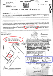
Figure 4: Record of Title OT325/238, Lot 3 DP 5544
The memorial in Figure 5 records that Transfer 438695/1 transferred ‘Part’ of Lot 3 DP 5544 in 1975 and that title OT6A/1462 was issued for this ‘Part’. Transfer 438695/1 therefore needs to be searched to determine if it includes a diagram defining the part of Lot 3 transferred. (Note that the instrument number in Landonline is 438695.1).

Figure 5: Enlarged memorial as shown on OT325/238
Figure 6 below shows the diagram attached to Transfer 438695/1, confirming that Lot 3 DP 5544 was subdivided by it. The area bordered blue is the area being transferred out (1027m2) and the area bordered red represents the balance parcel.

Figure 6: Diagram on Transfer 438695/1
The land under survey has therefore been created by a diagram on transfer.
In summary, surveyors should thoroughly search all relevant instruments relating to the parcel or parcels under survey and the adjacent parcels to ensure all the definition evidence has been collected and accounted for. When searching for evidence of a diagram on transfer:
- Trace back through historical titles until the ‘Whole’ appellation is found.
- Check the memorials for details of a transfer or other relevant instrument.
- Trace back through adjacent titles of the same ‘Part’ appellation until the ‘Whole’ appellation is found.
- Check the memorials on those titles.
- Check which transfers occurred first and that they coincide with the order of titles that were issued.
- Sometimes diagram on transfer boundaries may have already been defined by neighbouring surveys. It is important that the surveyor searches the adjacent parcels for any surveys that could have ground marked the boundary points and provided a more recent definition of the transfer boundaries.
Diagrams on transfer and the hierarchy of evidence
Although not usually surveyed, a diagram on transfer subdivision or boundary adjustment is treated as a full survey and the diagram dimensions must be respected exactly, subject to the considerations discussed below. In most situations, the diagram dimensions have the highest evidential weight within the hierarchy of evidence when defining diagram on transfer boundaries. However, there will be occasions when diagram dimensions cannot be maintained because they conflict with abutting surveys or titles of adjoining parcels that were not part of the same parent parcel.
Unpegged diagram on transfer boundaries
When defining unsurveyed boundaries originating from a transfer diagram, the dimensions of the first parcel(s) taken out must be respected at the expense of the balance of the underlying parcel and any subsequent land taken by diagram on transfer.
Figure 7 below is a diagram that provides no evidence of the boundary positions having been surveyed.
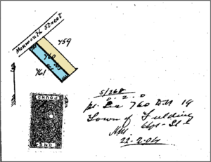
Figure 7: Transfer 48080 (Wellington)
In terms of the order of priority, the area coloured blue was transferred out of Lot 760 DP 19 by Transfer 48080 and is the first part transferred out. If a later survey found any conflicts in the parent parcel boundaries, the area coloured blue would retain its full dimensions and any excesses or shortages would be held by the balance area (coloured ochre).
Diagram on transfer boundaries with supporting survey information
Sometimes a diagram on transfer will include evidence that the new boundary was ground marked. This evidence can range from a note by a licensed or registered surveyor, to a diagram showing traverses and peg ties to support the monumented boundaries. Diagrams may also contain a field book reference which should be searched as it could include additional survey information.
Some transfer diagrams contain a note “Boundaries pegged” and are signed by a licensed or registered surveyor. However, there is often no record of the location of these boundary marks or occupation evidence on the diagram, in which case the surveyor must respect the order of priority.
Figure 8 below shows a diagram on transfer with a note from the Licenced Surveyor certifying that the boundaries have been ground marked. Despite this certification, the diagram does not show any survey work to support the definition of these boundaries.
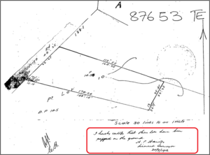
Figure 8: Transfer 87653 (Wellington)
In cases where the Diagram on Transfer boundaries were pegged and sufficient survey information is included on the diagram to support definition, the surveyor should use this information to reproduce the boundaries as pegged.
Figure 9 below shows the placement of a new iron tube and measurements to boundary pegs and other old marks, which were used to define the parcel being transferred out of the parent parcel. The survey information included on this diagram should be used to reproduce and define the boundaries that were pegged as part of the transfer. The fact that pegs were placed means they may still survive and should be looked for.
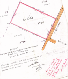
Figure 9: Transfer 121256 (Wellington)
Where a diagram on transfer boundary is supported by survey work, has been ground marked, as in Figure 9, and the information can be used to reproduce the boundaries as pegged, the dimensions are no longer subject to the strict order of priority and are subject instead to the accuracy standards of the applicable boundary class.
Sometimes surveyors may locate old boundary monuments which conflict with the transfer dimensions. If a conflict of this nature is identified, further searching and analysis of abutting surveys and titles to determine the priority of evidence will be required to resolve it. As discussed above, this may result in the definition being unable to maintain the transfer dimensions exactly.
Occupation
By carrying out a subdivision or boundary adjustment by diagram and dispensing with a survey the original owner forfeited all occupational rights to the portion transferred. Therefore, occupation should not be used to define the first parcel originating from a diagram on transfer. The transfer dimensions have priority. However, long-standing occupation (pre-dating or contemporaneous with the transfer) may be used to clarify ambiguity in transfer dimensions.
Shortage and excess
Under the principle of order of priority, dimensions of the first transfer out of the parent title have the highest priority and must be respected. If a later survey identifies a discrepancy in the parent parcel dimensions, any excess or deficiency is borne by the remainder of the parent parcel. Although a pragmatic approach has sometimes been taken to this principle, it is only within the context of ‘a little more or less’. With this proviso, the legal principle of the order of priority is the accepted practice when defining diagram on transfer parcels.
Simultaneous transfers
Surveyors will come across situations whereby more than one parcel of land has been transferred out of the parent title or grant at the same time. Provided they are the first transfers out, under the order of priority all parcels transferred on the same date are simultaneous transfers and are of equal evidential weight. In other words, provided they are the first transfers the dimensions of all parcels transferred simultaneously from the parent title or grant must be respected exactly.
Diagrams on transfer and limited as to parcel titles
Some titles created by diagram on transfer are limited as to parcels because the parent title or its predecessor was issued under the Land Transfer (Compulsory Registration of Titles) Act 1924 (LTA 1924). Titles issued under the LTA 1924 have the same status as guaranteed titles, except that they can be subject to adverse possession against the title of the registered owner (see section 204 Land Transfer Act 2017).
Where a title created by a diagram on transfer is limited as to parcels in terms of the LTA 1924, long-standing occupation may be relevant as evidence of loss of land from the title by adverse possession. However, adverse possession can only apply to original boundaries of the parent title, not to boundaries created by the diagram on transfer. The original owner, having transferred part of the land defined in the diagram on transfer to someone else, cannot subsequently claim title to some of it on the basis of occupying it. Figure 10 below illustrates the point.
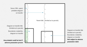
Figure 10: Diagram illustrating limited as to parcel titles created by diagram on transfer
One such example of a title created by a diagram on transfer being limited as to parcels can be found in the North Auckland land district. RT NA759/251 was a limited title issued under the LTA 1924 and subdivided by diagram on Transfer 576074 in 1956. RT NA1327/49 was issued for the portion transferred out and is also limited as to parcels.
For further information see:
Diagrams on transfer and computed plans
A boundary or boundary point created by a diagram on transfer should not be treated in the same manner as one created on a computed plan.
A computed plan was mathematically derived using existing data and a new boundary and/or boundary point was computed without field survey. It was prepared either under s 167(1) of the Land Transfer Act 1952 or any similar dispensation granted by the Surveyor-General. They are no longer recognised as a specific CSD type although surveyors are likely to encounter them occasionally.
Boundaries created by diagrams on transfer are subject to the order of priority, which requires the first transfer dimensions to be respected exactly. The remaining part of the parent parcel must accept whatever remains (be it an excess or shortage). There can be no pro-rata adjustment of the transferred dimensions. Computed plan boundary dimensions, on the other hand, may be subject to pro-rata adjustment by a subsequent survey.
Diagrams on deeds conveyances
The Deeds System was not a system of registration of title but a system that recorded the registration of instruments that affected the title to land. Conveyances of the land could be the whole or parts of a parcel originally granted to a person or persons by the Crown (Crown Grant). Conveyances of part parcels were in effect subdivisions and often contained diagrams of varying quality of boundary definition. Searching of conveyances usually reveals relevant information to support boundary definition and searching of Deeds Indexes will provide relevant information on the order of priority.
The order in which the owner progressively transferred/conveyed off parcels of land was recorded in the Deeds Indexes and the order in which they were conveyed survived on conversion to the LTA 1924. Therefore, deeds conveyances are directly associated with records of title that are limited as to parcels as they establish the underlying cadastre.
The order of priority principle applies equally to land under the Deeds System as it does to diagrams on transfer with the original Crown Grant considered to be the parent title, irrespective of the lack or poor quality of survey information. However, priority of a conveyance does not protect the conveyed land from adverse possession that started before the land was brought under the Land Transfer Act.
Boundary reinstatement surveys for diagram on transfer boundaries
A boundary position defined on a diagram on transfer may be reinstated but a survey for this purpose cannot be treated as a simple boundary reinstatement CSD because the boundary point has not been defined in an approved CSD. This requirement applies even if the diagram on transfer indicates that the position was monumented at the time of transfer.
This means that a reinstatement survey of a diagram on transfer must be a complex boundary reinstatement CSD (r 114(2)).
The reinstatement survey must record all the marks connected to by the survey and all the necessary information proving that the diagram on transfer boundary point is correctly located. In Landonline the survey purpose is Complex Boundary Reinstatement.
For further information on boundary reinstatement surveys see:
Unit developments and underlying diagram on transfer boundaries
A CSD for a unit development is permitted where a boundary of the underlying parcel has been defined in a diagram on transfer providing the record of title is not limited as to parcels. The accuracy between the boundary points of the units and the underlying parcel boundary points must comply with the appropriate accuracy specified in rule 27.
The survey report should include sufficient supporting information (such as a calculation sheet) to show how the boundary was defined in relation to other boundaries and is in accordance with the relevant accuracy tolerances.
If the accuracy tolerances cannot be met because an underlying parcel boundary is insufficiently defined, that boundary must be defined by survey and ground marked.
Refer to rules 13, 27, 35, 51 and 72.
For further information see:
Boundary marking and capture requirements for adoptions
All boundary points on an existing boundary created on a diagram of transfer that are part of a new primary parcel must be defined by survey and ground marked, if practicable (r 35(2)(c) & r 13(d)). The only exception is where the boundary and its associated boundary points can be accepted under rule 15.
Boundary points adopted from a diagram on transfer should be named in terms of their source (such as UNMK (1) T 48080, PEG (1) T 121256).
Vectors adopted from a diagram on transfer should be captured as calculated vectors rather than adopted and the transfer document/instrument referred to as the adoption source in the survey report.
Refer to rules 13, 14, 15 and 35.
For further information see:
Reporting
Rule 72 (information to be included in the survey report) requires surveyors to report on the information considered when defining existing primary parcel boundaries by survey. If a transfer document contains information relevant to the definition of the land under survey, this should be reported on. Subsequent surveys of parcels created by diagram on transfer may be subject to conflict and rules 72(f) and (i) require surveyors to report on any conflicts identified and how they have been resolved.
Refer to rule 72.
For further information see:
Tips for preparing a CSD containing Diagram on Transfer boundaries
The tips and questions in this section provide a useful framework for reporting.
- Confirm whether the ‘Part’ lot(s) under survey have been created by diagram on transfer.
- Ensure that copies of all relevant transfer documents have been identified, located and investigated. Ask the following questions:
- In which order did each 'Part' get transferred out of the parent title?
- Does this CSD survey the first part transferred out?
- Does the CSD survey a subsequent transfer?
- Does it survey the balance?
- Does the transfer document show evidence of ground marking or other survey work?
- Ensure the dimensions of the first parcel transferred out of the parent parcel respect the transfer document and check the following:
- Where a parent parcel has had multiple transfers, has the order of priority been followed?
- Have any shortages or excesses identified in the parent parcel been left in the balance?
- How should the shortages or excesses be distributed?
- Have original boundary monuments been found?
- Is there a conflict between these old monuments and the transfer dimensions?
Diagram on Transfer dataset examples
DP 480751 – part parcels defined by diagrams in Transfers T 48081 and T 48082 were transferred out of NL62/298. NL4B/977 was subsequently issued for the balance. DP 480751 redefined RT NL4B/977, respecting the definitions by the diagrams in Transfers T 48081 and T 48082 (south western boundary).
DP 539808 - subdivides Part Section 35 and 36 Rangitikei Agricultural District in WN337/177 and uplifts the limitation as to parcels. The south eastern boundary, in common with the adjoining WN337/178 (Ltd), is defined by adoption from SO 19502 and Deeds Index 25/275 (including the diagram contained in Conveyance 137622) and old occupation. There is conflict along the eastern end of this boundary between the conveyance distance and a 100-year-old post situated on the boundary that appears to pre-date the issue of title under the Land Transfer Act. Conflict has been resolved by giving the conveyance dimension priority over occupation, resulting in a 5.35m ‘sliver’ being created that has been left out of the resultant Lot 2.