
Steps
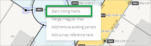
- Right click on the spatial view and select Start linking marks.
- All the marks on the spatial view will be highlighted orange, the Mark linking panel will appear and there will be a blue line attached to the end of your cursor indicating that you are intending to connect (link) the captured mark with an existing mark.


- Left click on the captured mark you want to link.
- Left click the corresponding underlying existing mark and select Link. Landonline links the captured mark to the closest mark. You will see a pop-up message confirming the mark was successfully linked.

- The link displays as a square symbol drawn around the linked marks.
- Repeat Steps 2 and 3 to link all captured marks where corresponding Landonline marks exist, or see Automatic Mark linking.
If you link a captured mark to a geodetic mark, the captured mark is overridden with details of the geodetic mark. You cannot edit the name of the mark (i.e. Mark Type Abbrev, Mark No, Mark Plan Ref fields) or the Mark Type field, but you can change other fields if required. If you change the Mark State to Adopted, the Condition field will automatically default to Not Specified, but remains an editable field.
To report any edits for geodetic marks you have linked in the survey, refer to the information generated in the Pre-validation report.