
The NZMGI working group was established in February 2019. It is made up of over 180 members from across government, Māori / iwi groups, Crown Research Institutes, universities, charity and community groups, and private sector companies. The steering group coordinates the activities of the NZMGI working group and oversees the development and implementation of a national marine geospatial work programme. Decisions made by the steering group consider the needs of the wider marine geospatial community. The steering group consists of representatives from the NZMGI working group with a key national role in the generation and/or use of marine geospatial data:
- Department of Conservation | Te Papa Atawhai
- GNS Science | Te Pū Ao
- Land Information New Zealand | Toitū Te Whenua
- Maritime New Zealand | Nō Te Rere Moana Aotearoa
- Ministry of Business, Innovation & Employment | Hīkina Whakatutuki
- Ministry for the Environment | Manatū Mō Te Taiao
- Ministry for Primary Industries | Manatū Ahu Matua
- National Institute of Water and Atmospheric Research | Taihoro Nukurangi
- New Zealand Defence Force | Te Ope Kātua o Aotearoa
- Office of Treaty Settlements and Takutai Moana | Te Tari Whakatau
- Regional councils
Join us
If you are interested in being involved in, or finding out more about, the NZMGI working group, email us at hydro@linz.govt.nz with 'Attn: NZMGI Working Group' in the subject line.
Work programme
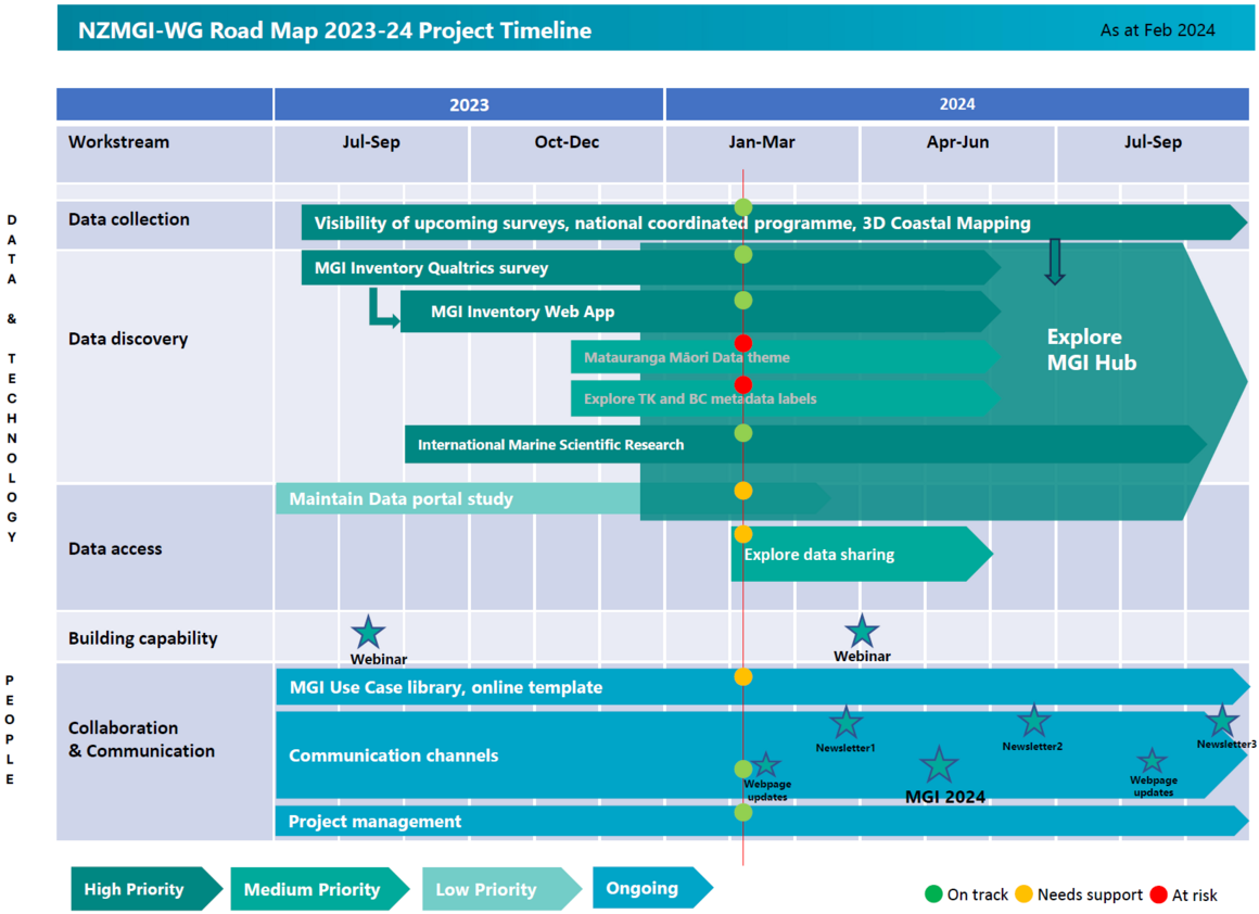
The NZMGI work programme consists of prioritised projects, each contributing towards the goals of the working group.
The projects within the work programme are led by different members of the steering group.

Keep up to date
We created Pānui Ahumoana to increase communication with the NZMGI working group and the wider community. Pānui means to announce or notify in te reo and is reflective of this newsletter’s purpose. Ahumoana relates to the marine environment.
- Aug 2024 - Issue 07
- Mar 2024 - Issue 06
- Nov 2023 - Issue 05
- Aug 2023 - Issue 04
- Mar 2022 - Issue 03
- Sep 2021 - Issue 02
- Mar 2021 - Issue 01
Working group meetings
The NZMGI working group meets once or twice each year, either in person or virtually. All members are encouraged to participate.
Agendas and minutes of meetings
3 May 2024 NZMGI annual working group meeting
https://youtu.be/pd4bTV4ppoI
This year's annual meeting was held at GNS Science in Lower Hutt, Wellington on Friday 3 May 2024. The meeting provided a forum to exchange knowledge and ideas to facilitate national collaboration and leverage opportunities to grow the value of marine geospatial investments and benefits for all Aotearoa.
The meeting attracts a growing number of scientists and professionals including ecologists, geologists, hydrographers, spatial analysts, consultants, and more.
17 Feb 2023 NZMGI working group meeting
https://youtu.be/nph0TtbB4_k
11 Nov 2021 NZMGI working group meeting
https://www.youtube.com/watch?v=bBUb23mzzxE
28 Jul 2020 NZMGI working group meeting
11 Sep 2019 NZMGI working group meeting
19 Feb 2019 NZMGI working group meeting
Steering group meetings
The steering group meets every 2 months either in person or virtually.
Minutes of meetings
2024 NZMGI steering group meetings
2023 NZMGI steering group meetings
2022 NZMGI steering group meetings
2021 NZMGI steering group meetings
2020 NZMGI steering group meetings
2019 NZMGI steering group meetings