Skip to main content Skip to navigation
  • Mō mātou About us
  • Kōrero whakapā Contact us
  • Whakapāpātanga Consultations
  • Rauemi Resources
  • Ara mahi Careers
Toitū Te Whenua Land Information New Zealand Toitū Te Whenua - Land Information New Zealand
  • Our work Ā mātou mahi
  • Products & services Ngā hua me ngā ratonga
  • Guidance Kōrero ārahi
  • News Karere
  1. Home
  2. Products & services
  3. Place names
  4. New Zealand Geographic Features

New Zealand Geographic Features

Ngā Āhuatanga Matawhenua o Aotearoa

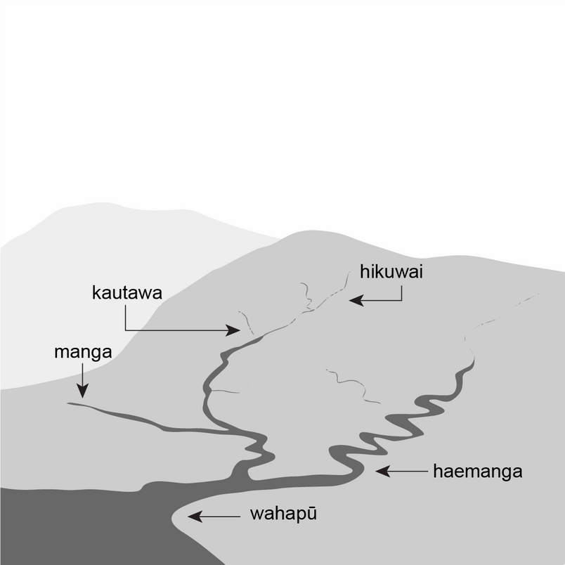
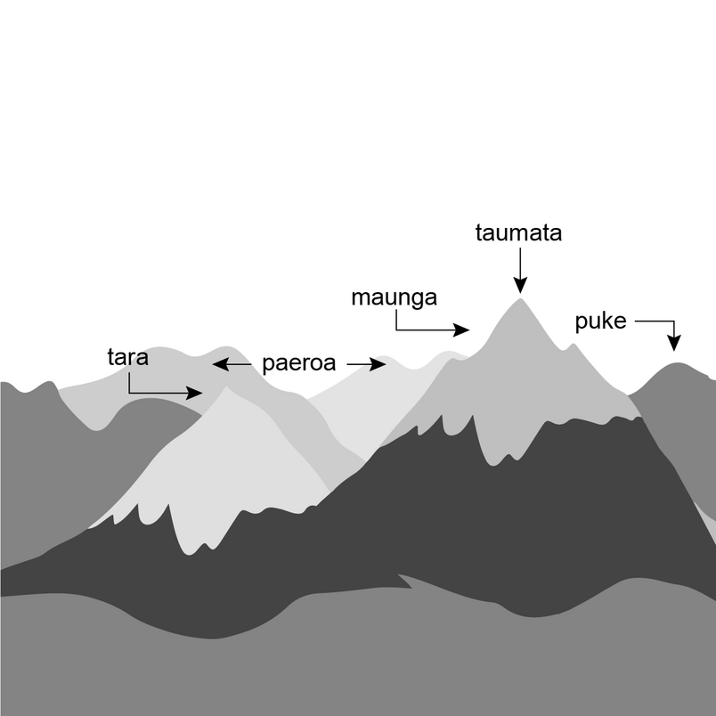
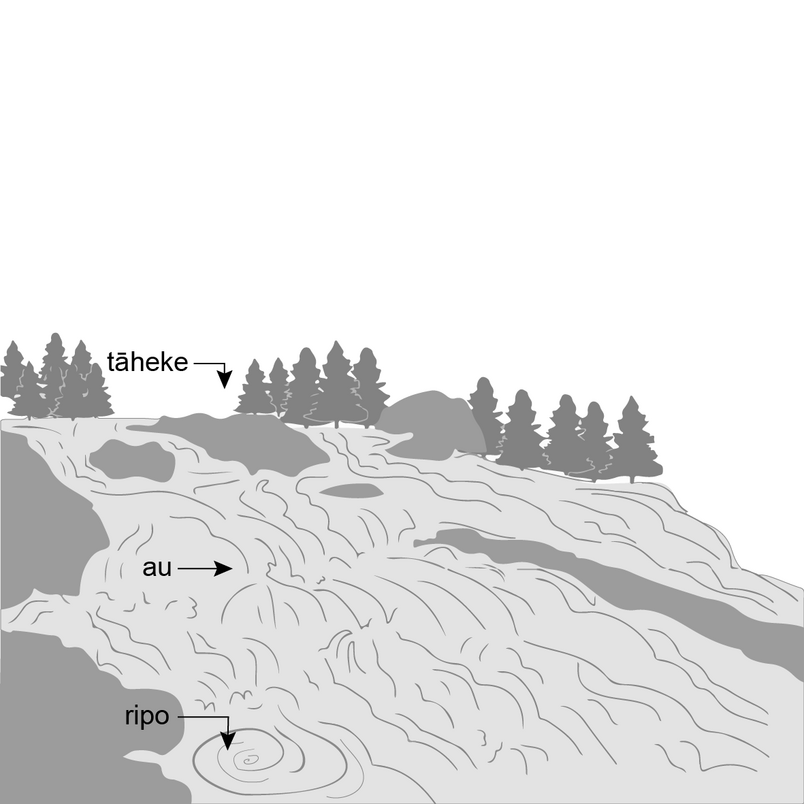
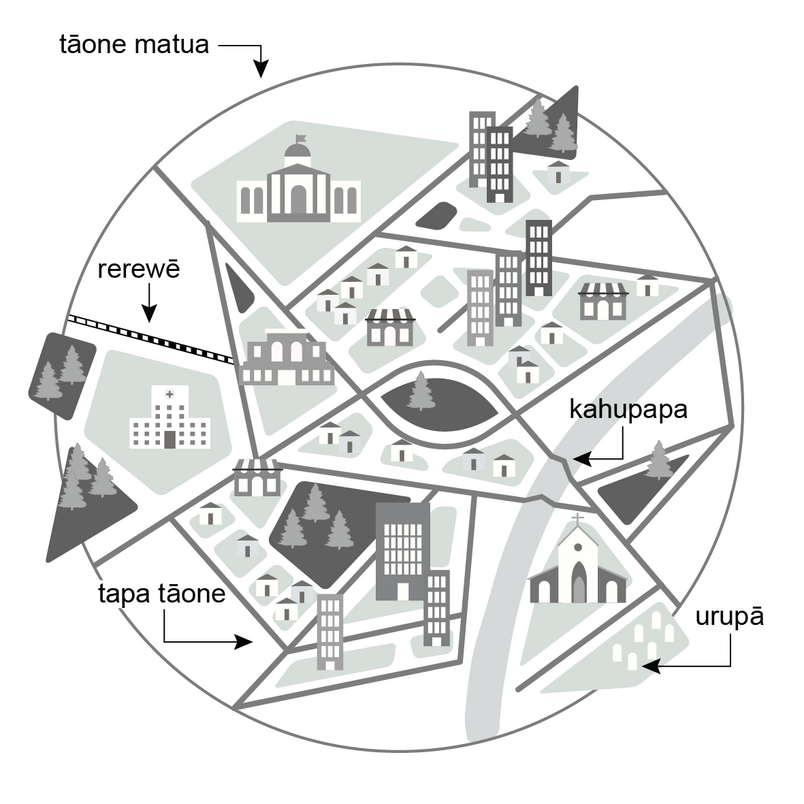
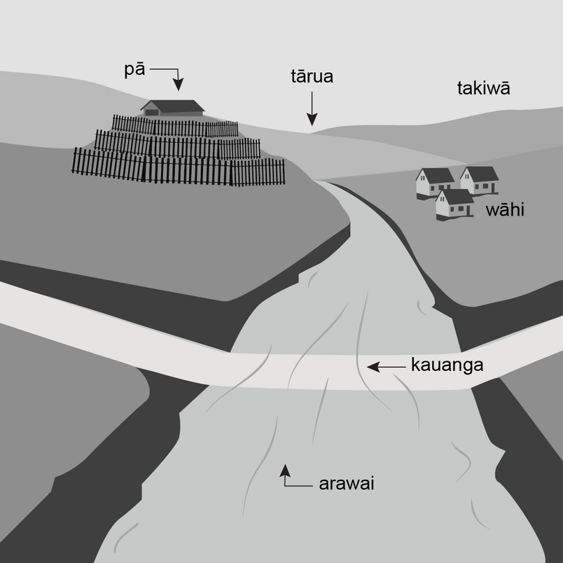
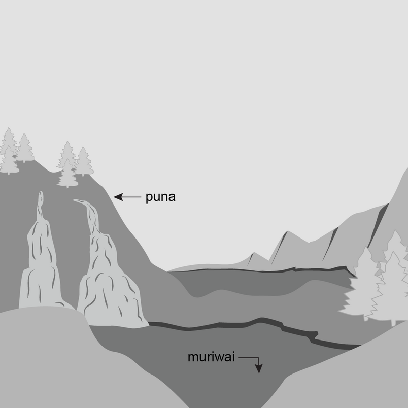
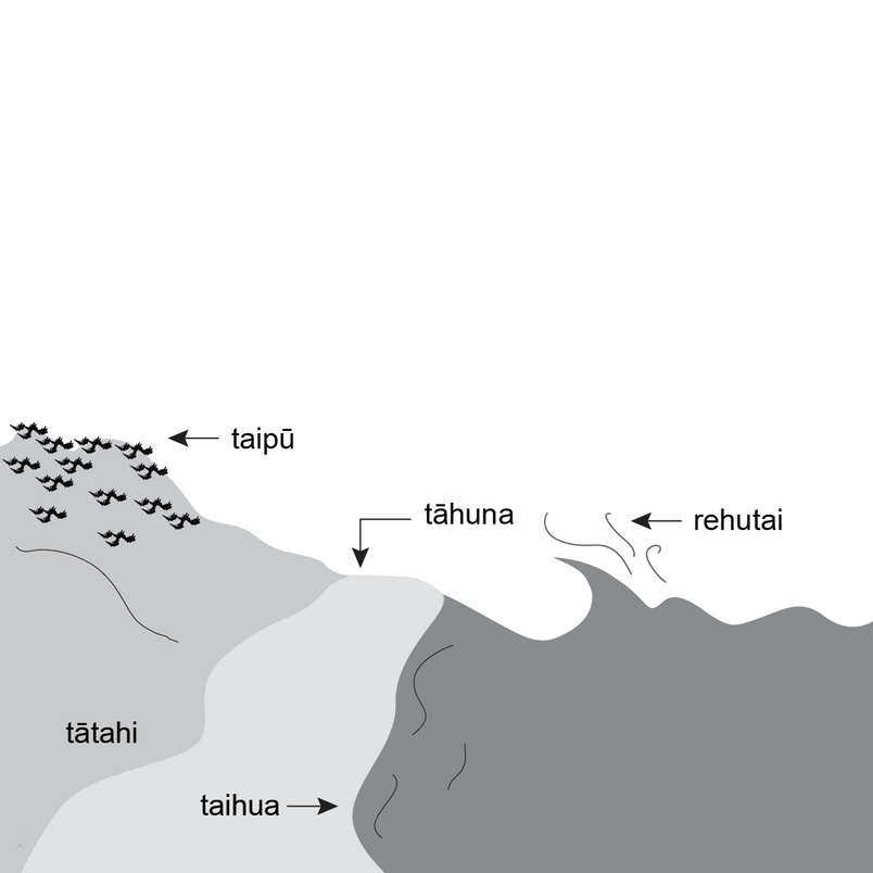
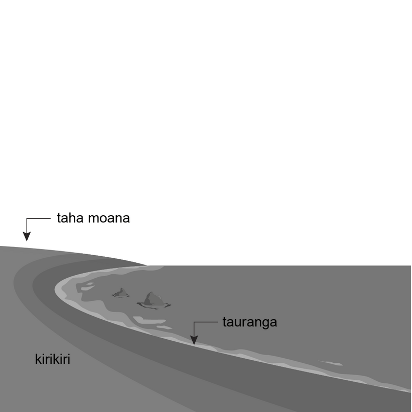
Search for images and descriptions of Aotearoa New Zealand's geographic features.

Nga Pou Taunaha logo in white on a gradient of Ngahere and Moana
Loading…
We couldn't find any results that matched that search.
  • Download the geographic features:

    List of New Zealand's geographic features
  • Ko taku iwituaroa tēnā | My land, my backbone
  • Drawing of a coastline with a harbour and bays.
  • Drawing of streams running down a hill and into a body of water.
  • Drawing of a bluff with trees above and a body of water below.
  • Drawing of a river running through a wooded plain.
  • Drawing of a forest with a stream winding through it and a hole in the ground in the foreground.
  • Drawing of the peaks of a mountain with foothills below.
  • Drawing of two islands. A small island with a lighthouse and a larger island with a hill with small bays around its coastline.
  • Drawing of a lake with plants around it and a small hill behind it. Also pictured is a small pond.
  • Drawing of a rock face with a narrow ledge cutting across it and a cave entrance.
  • Drawing of snow-capped mountain peaks and lower round-topped hills.
  • Drawing of a coastline with a peninsula, a small rounded promontory and a bight between the two.
  • Drawing of a water line. Underneath the water there is a trough in the seafloor with a bank above it.
  • Drawing of a section of river, with water churned up by rocks, eddies and a small whirlpool.
  • Drawing of a coastline with piles on rocks on the beach, larger rocks protruding from the water and rock pillars in the distance.
  • Drawing of a trig beacon.
  • Drawing of a stream flowing down through a valley and into a body of water.
  • Drawing of the top of volcano with an indentation at its peak.
  • Drawing of a waterfall falling steeply from a mountain valley to a body of water.
  • Drawing of small pond with rising steam, steam vents and a geyser.
  • Drawing of the cross section of an iceberg and a large ice plateau, bank and shelf.
  • Drawing of a pond surrounded by rocks and grass.
  • Drawing of cone-shaped hill, a rock pillar, a flat-topped hill and a jagged chasm.
  • Drawing of a circle containing geometric shapes that contain symbols of buildings, houses, trees, a graveyard and railway line.
  • Drawing of a fan-shaped are of coastline bisected by forks of a river. Also pictured is a hollow in the ground.
  • Drawing of a stream bisected by a ford. Also pictured are a few houses, one on a hill surrounded by palisades.
  • Drawing of a glacier and hillside cut with vertical snowy crevasses.
  • Drawing of a sound with bays, an isthmus, a channel and spit.
  • Drawing of a lagoon set in hilly ground. Also pictured is a hill with two streams running down it.
  • Drawing of a river with a ditch running parallel. Also pictured is a hill with a slip and debris falling into the river making a fan shape.
  • Drawing of a high-sided cape with houses and a flock of birds.
  • Drawing of a sloping hillside and a browed summit with a shoulder shaped landform below.
  • Drawing of a dam with water running down it and a long bridge.
  • Drawing of a stream with plain and house on one side and a camp and path on the other.
  • Drawing of a wave, a beach and a sand dune.
  • Drawing of a coastline with small rocks and a gently rising shoreline.
  • Drawing of a calm body of water bounded by landmasses with deeper, rougher water beyond.
  • Drawing of a road tunnel with a town above it.
  • Drawing of a wharf in enclosed water with a passage to open water. Also pictured is a lookout on top of a hill.
↑ Back to top
  • Ā mātou mahi Our work
    • Crown property management
    • Location information
    • Overseas investment regulation
    • Property information system
    • Statutory and support roles
    • Māori and iwi development
    • New Zealand Geographic Board
    • Projects
  • Ngā hua me ngā ratonga Products & services
    • Accredited suppliers
    • Camping areas
    • Charts
    • Crown property applications
    • Data
    • Geodetic
    • Land records
    • Landonline
    • Maps
    • Maritime safety
    • Place names
    • Tenancy, land and property management
    • Tides and tidal streams
    • Products and services A - Z
  • Kōrero ārahi Guidance
    • Crown property
    • Data service
    • Geodetic system
    • Land registration
    • Landonline support
    • Marine information
    • Overseas investment
    • Place naming
    • Property addressing
    • Property valuation
    • Survey
  • Karere News
Toitū Te Whenua Land Information New Zealand Toitū Te Whenua Land Information New Zealand
  • Mō mātou About us
  • Kōrero whakapā Contact us
  • Whakapāpātanga Consultations
  • Rauemi Resources
  • Ara mahi Careers
  • Facebook
  • LinkedIn
  • YouTube

© Copyright Toitū Te Whenua

  • Accessibility
  • Copyright
  • Disclaimer
  • Link requests
  • Privacy
Shielded site
Te Kāwanatanga o Aotearoa New Zealand Government New Zealand Government