
Overview
The Public Works Act 1981 (PWA) enables the Crown and local authorities to acquire land for public works. If they cannot obtain the land by negotiation with the owner, the PWA provides for the land to be taken compulsorily.
Before proceeding to take any land compulsorily, the Crown or local authority must, in accordance with sections 23, 23A and 23E PWA:
- cause a plan of the land intended to be taken to be prepared
- publish a notice of intention to take the land in the New Zealand Gazette (gazette notice)
- serve notice on the owner of the land and any registered interest holders.
A copy of the gazette notice will be recorded on the relevant record of title.
The plan of the land intended to be taken must be certified by a licensed cadastral surveyor, and lodged with LINZ for approval and recording in the cadastre.
This plan will be referred to in the gazette notice, be available for searching in Landonline, and accompany the notice served on the landowner.
The requirement for a plan does not apply in the circumstances specified in section 32 PWA, for example where it is proposed to deal with all the land in an existing surveyed parcel.
Sections 39AAH, 39Q and 39R PWA vary some of the requirements of section 23 PWA for critical infrastructure projects and emergency recovery purposes, but not the plan requirements.
Refer to:
- New Zealand Gazette
- Section 23 – Notice of intention to take land
- Section 23A PWA – Requirements for notice and related plan
- Section 23E PWA – Recording and notation of matters relating to notice
- Section 39AAH PWA – Notice of intention to take land (for critical infrastructure projects)
- Section 39Q PWA – Notice of intention to take land (for emergency recovery)
- Section 39R PWA – Requirements for notice and related plan (for emergency recovery)
- Schedule 1 PWA – Notice of intention to take land for public work (form)
Plan requirements
A plan prepared to support a notice of intention to take land, as required by section 23(1)(a) PWA and referred to in this guidance as a s23 PWA plan, is not a cadastral survey dataset (CSD) under the Cadastral Survey Act 2002, and the Cadastral Survey Rules 2021 do not apply.
The legal requirements for a s23 PWA plan are set out in section 23A(1) PWA.
A s23 PWA plan has three key components:
- an aerial photo plan showing the proposed boundaries of each portion of land to be taken in relation to the affected parcel
- a schedule setting out specified information for each portion of land to be taken
- certification by a licensed cadastral surveyor that the plan is in accordance with section 23A(1) PWA.
All s23 PWA plans lodged with LINZ under section 23(1)(a) PWA must be submitted using Landonline. The specific survey purpose Sec23 PWA – Intention to Take Land in Landonline must be used for these plans.
For further capture guidance refer to Landonline capture requirements.
The following sections provide guidance on meeting the requirements of section 23A(1) for approval of a s23 PWA plan under section 23E(1)(b) PWA.
Aerial photo plan
The aerial photo plan must clearly and unambiguously show which parts of the land are proposed to be taken, so the owner can reasonably determine on the ground what land is affected. The plan must also be able to withstand scrutiny if an objection to the notice of intention to take land is made to the Environment Court.
The aerial photo plan should:
- show the proposed boundaries of the portions of land to be taken
- use colour aerial imagery that is sufficiently detailed and up to date to enable the proposed boundaries to be located in relation to identifiable physical features that exist on the ground
- show the boundaries and appellations of the existing parcels of land affected by the proposed land taking
- clearly distinguish between existing and proposed boundaries, except where they coincide, in which case only the proposed boundary needs to be shown
- show a unique identifier for each portion of land to be taken
- have a title that clearly states the purpose of the plan
- show a north point
- be drawn to scale
- include a note providing the source and date of the aerial imagery
- include a note stating the SO plan number allocated in Landonline for the s23 PWA plan, and confirming that the aerial photo plan forms part of that plan and that the plan has been certified as being in accordance with section 23A(1) of the Public Works Act 1981
- include the current version name and date for the aerial photo plan
- show on every page, the page number and the total number of pages
- be clear and legible when printed at A3 size.
The aerial photo plan may include a survey firm name and logo and additional notes for clarification.
Leases, easements and covenants
- The aerial photo plan is only required to show existing leases, easements or covenants that will be affected by the proposed taking.
- New easements and covenants should only be shown if they are intended to be taken compulsorily.
Accuracy
It is the responsibility of the licensed cadastral surveyor to ensure that the existing and proposed parcel boundaries and their relationship to the aerial imagery are depicted to a sufficient level of accuracy for the purposes of section 23A(1) PWA.
Where the nodes for the relevant existing parcel boundaries have Survey-accurate digital cadastre (SDC) status, the accuracy of the existing boundaries in Landonline should be adequate.
Where existing boundary nodes are not SDC, the cadastral source data may need to be used to ensure the boundaries are depicted to a sufficient level of accuracy.
Geo-referencing of the boundaries and aerial imagery will need to be confirmed by the surveyor. Sometimes, this may require ground verification.
In some cases, the location of an existing boundary may be uncertain because its position cannot be determined to a sufficient level of accuracy from prior approved surveys and estate record information. If the licensed cadastral surveyor considers that the extent and area of the land to be taken can be adequately shown on the aerial photo plan for the purposes of section 23A(1) PWA, despite the uncertainty of the existing boundary, the photo plan must label that boundary “Boundary location uncertain” and include a brief explanatory note on the plan.
However, if uncertainty about an existing boundary means the extent and area of a portion of land to be taken cannot be adequately determined, the licensed cadastral surveyor should consider whether a cadastral survey and cadastral survey dataset are required.
Refer to Use of a cadastral survey dataset for s23 PWA purposes.
The licensed cadastral surveyor should consult with the requiring authority to confirm whether a s23 PWA plan or CSD will meet the authority’s requirements for notice of intention.
Supporting document type
The following supporting document requirements ensure the approved aerial photo plan can be found in Landonline and referenced from the plans generated for the s23 PWA plan.
The colour aerial photo plan must be attached to the s23 PWA plan in Landonline as a Sec23 PWA – Plan Graphic supporting document.
Because the Sec23 PWA – Plan Graphic supporting document does not bundle with the Record of Survey or Title Plan, a separate Plan Graphic supporting document containing a reference note identifying the location of the approved aerial photo plan must also be attached to the s23 PWA plan. The note must include:
- the supporting document type and ID of the Sec23 PWA – Plan Graphic supporting document
- the SO plan number for the s23 PWA plan
- the version name and date of the approved aerial photo plan in the Sec23 PWA – Plan Graphic supporting document.
An example of a suitable note is “See supporting document Sec23 PWA Plan Graphic ID 9000168 for the approved aerial photo plan for SO 4000310 (Version A – 8/09/2026)”.
The Plan Graphic supporting document must contain only the reference note and must not include an image of the aerial photo plan.
Height limits and permanent structures
If a portion of land intended to be taken has height limits or relates to permanent structures on a Unit plan, additional information must be included in the s23 PWA plan to comply with section 23A(1)(a) PWA.
Consideration should be given to how the landowner will be able to understand the location and extent of the land intended to be taken. It will likely be necessary to include additional diagrams to show this. Such diagrams should be included as additional pages in the Sec23 PWA – Plan Graphic or attached as an additional Plan Graphic. If reduced levels are included in the s23 PWA plan, the vertical datum that the levels are in terms of must also be included on the diagrams.
Schedule
The schedule must:
- include, for each portion of land to be taken that is shown on the aerial photo plan:
- its unique identifier
- the appellation of the affected parcel
- the record of title (or other estate reference) for the affected parcel
- the purpose for which it will be used
- its area expressed in hectares or square metres
- identify the type of interest being taken if it is not a freehold interest (e.g. lease, easement, covenant).
The schedule may also note that the areas of the portions of land to be taken are subject to survey.
The schedule may be:
- shown on the aerial photo plan; or
- included with the aerial photo plan as one or more separate pages in the Sec23 PWA – Plan Graphic supporting document; or
- attached as an Area Schedule supporting document.
Certification
When submitting a s23 PWA plan in Landonline, the licensed cadastral surveyor will be prompted to certify that the plan is in accordance with section 23A(1) PWA. This certification will display on the header page of the Record of Survey and Title Plan generated in Landonline.
Fees
A fee will be charged on submission of a s23 PWA plan in accordance with the Schedule Part 7 item 2A of the Land Information New Zealand (Fees and Charges) Regulations 2003.
Sample s23 PWA plan
Use of a cadastral survey dataset for s23 PWA purposes
In some cases, it may be preferable to carry out a cadastral survey and prepare a CSD under the Cadastral Survey Rules 2021 (CSR 2021) that can be used for notice of intention purposes under section 23(1)(a) PWA. For example, a survey and CSD may be needed to determine the position of an existing boundary of the affected land more accurately.
This is acceptable, if the CSD also contains the information required by section 23A(1) PWA, as follows:
- An aerial photo plan attached as a Sec23 PWA – Plan Graphic supporting document to satisfy section 23A(1)(b).
- The schedule required by section 23A(1)(c) attached as an Area Schedule supporting document.
- Certification by the licensed cadastral surveyor that the plan is in accordance with section 23A(1) PWA, included as an ordinary Plan Graphic supporting document that will bundle with the Title Plan.
The CSD would typically be a SO plan with a survey purpose of “Legalisation” and full capture. The survey report must state that the CSD will be used for section 23 PWA purposes (r 72(a) CSR 2021).
This CSD may also be suitable for proclamation purposes if it meets the requirements of section 26(1C)(a) PWA and the CSR 2021.
Landonline capture requirements
The following guidance is not exhaustive and only addresses capture requirements that are unique to s23 PWA plans.
For more general information on Landonline capture, see Landonline - Survey support.
Create survey
Create a new survey using Survey purpose 'Sec23 PWA – Intention to Take Land'.

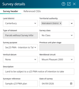
Survey details
- Select the Land district, Territorial authority and NZGD 2000 Meridional circuit that the affected parcels are located in.
- The Type of dataset is automatically set to ‘Parcels without Survey Information’, as this is the only available option for s23 PWA plans.
- Select ‘None’ for Vertical datum, or if the land intended to be taken is limited in its vertical extent by reduced levels, select the vertical datum the levels are in terms of.
Do not capture any Referenced CSDs.

Marks and vectors
Do not capture any marks or vectors.
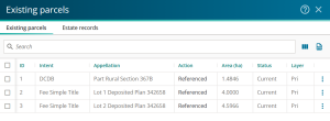
Existing parcels
Add existing affected parcels to Existing parcels as 'Referenced'.
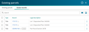
Add Estate records.


New parcels
Do not capture any new parcels.
Survey reference
Add a Survey reference to spatial view. Right click in the correct location and select 'Add survey reference here'.
Supporting documents
Do not create:
- an easement schedule/memorandum
- a survey report.
Add supporting documents:
- Sec23 PWA - Plan Graphic – colour aerial photo plan
- Area Schedule, if not included in the Sec23 PWA - Plan Graphic
- Plan Graphic – reference note only for Sec23 PWA - Plan Graphic.
Pre-validation, Plan Generation, certify and submit
- Run pre-validation. Confirm no failures and check warnings.
- Run Plan Generation.
- Certify “that this plan is in accordance with section 23A(1) of the Public Works Act 1981” and submit.